Difference between revisions of "Morphology of estuaries"
Dronkers J (talk | contribs) |
Dronkers J (talk | contribs) |
||
| Line 356: | Line 356: | ||
|AuthorName=Dronkers J}} | |AuthorName=Dronkers J}} | ||
| − | [[Category: | + | [[Category:Physical coastal and marine processes]] |
| − | |||
[[Category:Estuaries and tidal rivers]] | [[Category:Estuaries and tidal rivers]] | ||
| − | [[Category: | + | [[Category:Morphodynamics]] |
| − | |||
| − | |||
Revision as of 21:16, 28 June 2019
This article presents an overview of morphological characteristics of estuarine systems occurring around the world. First, major principles of estuarine morphology and underlying dynamics are summarised, according to which a classification scheme is introduced. This is followed by a more detailed discussion of particular estuaries, which are exemplary for different types of estuarine systems.
Contents
- 1 Definition of estuarine systems
- 2 Morphodynamic feedback
- 3 Tide-dominated systems [2]
- 4 Wave-dominated systems
- 5 River-dominated systems [12]
- 6 Mixed estuarine systems
- 7 Estuary classification
- 8 Estuarine morphology: examples
- 8.1 Charente estuary
- 8.2 Columbia River estuary
- 8.3 Curonian Lagoon
- 8.4 Dyfi estuary
- 8.5 Ebro delta
- 8.6 Gomso Bay
- 8.7 Hooghly estuary
- 8.8 Mahakam delta
- 8.9 Mekong delta
- 8.10 Mussulo Lagoon
- 8.11 Senegal River delta
- 8.12 Wadden Sea
- 8.13 Western Scheldt and Scheldt estuary
- 8.14 Willapa Bay
- 8.15 Yellow River delta
- 8.16 Zambezi River delta
- 9 Related articles
- 10 Further reading
- 11 References
Definition of estuarine systems
The Latin word “aestuarium” means: tidal inlet. Based on morphologic considerations, we adopt here another definition of estuarine systems:
Any coastal inlet shaped in the Holocene era by natural erosion, sedimentation and transport processes.
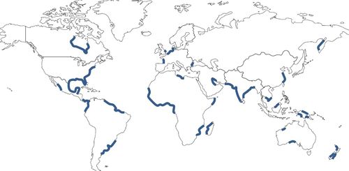
By this definition we exclude coastal systems with a morphology strongly constrained by pre-existing geology (fjords, rias) or by engineering works. Geological constraints are rarely absent from coastal systems, but in many cases their influence on morphological development is minor compared to the influence of sediment dynamics. This is the case, in particular, for estuarine systems which have developed by marine transgression of a gently sloping coastal plain. Coastal plains are present along many coasts, as shown in figure 1. The estuarine systems considered here are typically situated in these zones.
From this definition we may expect that estuarine systems with similar sediment inflow (quantity and quality of sediment), similar river discharge, similar tide and similar wave climate will exhibit similar morphologic characteristics. In practice, situations where these factors are exactly the same hardly exist. Therefore a great diversity of estuarine systems should be expected.
Morphodynamic feedback
Morphology and the forcing agents, waves and currents, mutually interact: while morphology is shaped by currents and waves, it modifies current and wave patterns at the same time. This mutual interaction reduces the diversity of estuarine morphologies occurring in reality. For example, when a channel bed is scoured by strong currents, the channel depth increases, which entails a decrease of the current strength (negative feedback). Interaction occurs at different spatial and temporal scales. For example, sediment import in an estuarine system by tidal currents modifies the overall morphology, which in turn modifies the tidal characteristics and the sediment import in the system [1].
Morphodynamic feedback acts in a way to select certain morphologic patterns. This is explained in the articles Stability models and Rhythmic shoreline features. Field observations show that estuarine systems, where the relative importance of river-induced, wave-induced and tide-induced processes is similar, have many morphologic features in common.
Tide-dominated systems [2]
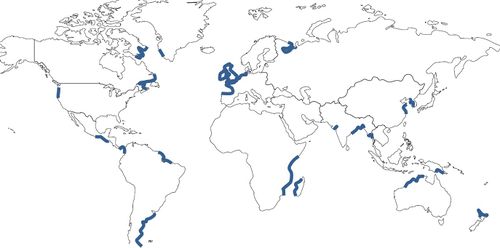
Tide-dominated estuarine systems occur on coasts with strong semi-diurnal tides, see figure 2. A mouth barrier is absent or reworked into a submarine ebb-tidal delta. The mouth is wide; estuarine channels are narrowing inland. Examples are the Charente and the Hooghly estuaries. In many estuaries the channel thalweg is scoured into pre-Holocene deposits, with a clayey or gravelly substrate. At the head of the estuary a single main channel connects to the river upstream. Tidal flats are present along the channels; they are mostly built with sediment imported from the sea. An example is Gomso Bay. The highest landward parts of tidal flats develop into vegetated salt marshes, unless this is prevented by frequent strong wave action. These marshes are flooded only at high water. The coarsest sediments are found at the estuarine mouth, where strong tide- and wave-induced currents act on the bed. Fine sediments are deposited on the tidal flats and in the inland channels. Most of the fine sediments in the upper estuarine zone are of fluvial origin. See the article Coastal and marine sediments for a more detailed discussion of sediment characteristics.
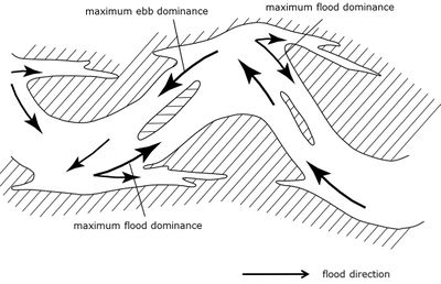
Channels are deeply scoured if the channel bed is sufficiently erodible, but they can remain shallow if the substrate is very hard or if the substrate, on the other hand, consists of very mobile non-cohesive fine sediment. Tidal channels are typically meandering, which is the result of non-linear interaction between morphology and flow dynamics - due in particular to the "overshoot" of the flow at channel bends (so-called inertial delay). The same phenomenon also makes that flood and ebb flows tend to follow different paths through the estuary, eventually leading to a multi-channel system of flood and ebb dominated channels [3], as schematically displayed in figure 3. In places where flood and ebb channels intersect, sand transport converges. This creates thresholds, which form an obstacle to shipping. In order to prevent nuisance to shipping, these thresholds must be dredged regularly. An example is the Western Scheldt. Lateral migration of meandering channels occurs in estuaries with strong tides if the channel bed consists of sufficiently mobile sediments. Fast channel migration is observed, for example, in the mega-tidal Baie du Mont Saint Michel [4]. Migrating channels can reshape the estuarine landscape by their strong lateral scouring power.
The tidal wave is distorted when propagating up-estuary. Higher harmonic components are generated with frequencies that are multiples of the frequency of the dominant semi-diurnal tidal frequency M2. The harmonic M4 tide is particularly relevant, because it generates flood currents of different strength compared to ebb currents. For strongly converging (upstream narrowing) estuaries the tidal amplitude increases; after reaching a maximum the tidal amplitude decreases further upstream where fluvial influence becomes substantial. In most tide-dominated estuaries the high-water (HW) crest of the tidal wave travels faster than the low-water (LW) trough, due to the greater water depth at HW compared to LW. In this case an asymmetry develops with shorter flood duration and longer ebb duration. Therefore, flood currents are generally stronger than ebb currents in the lower part of the estuary; this favours import of marine sediment. Estuarine circulation, driven by salinity gradients, also contributes to sediment import. However, under conditions of high river discharge, sediment export dominates over import. Tide-induced import and river-induced export both contribute to the net long-term sediment balance of the estuary [5]. The different factors that influence tidal wave asymmetry and tide-induced net sediment transport are discussed in the articles Tidal asymmetry and tidal basin morphodynamics and Ocean and shelf tides.
Wave-dominated systems
Wave-dominated systems are characterised by a coastal barrier, built shoreward of the breaking zone by wave-induced cross-shore sediment transport and longshore sediment transport. Breaching of a coastal barrier may occur under conditions of high storm surges or extreme river discharge. If the coastal barrier is backed by a low-lying wide coastal plain, the sea will scour a large inlet in the coastal barrier and transforms the coastal plain into a lagoon. Examples are the Curonian Lagoon and Mussulo Lagoon. If the lagoon is situated on a mesotidal or macrotidal coast, the inlet channel will be scoured (depth and width) such that the peak tidal velocity prevents restoration of the sandy barrier by longshore sand transport; a corresponding peak tidal velocity of around 1 m/s is generally observed in lagoon inlet channels[6][7]. Tidal currents also scour a channel system inside the lagoon; part of the eroded sediments are exported and deposited in an ebb-tidal delta. Another part of the sediment is deposited in the lagoon to form extensive tidal flats. An example is the Wadden Sea. The slope of the coastal plain determines the landward lagoon boundaries. The planform of coastal lagoons is therefore often rectangular and laterally elongate in the case of a steep coastal plain slope. An example is Willapa Bay.
In short lagoons the water level oscillates with the offshore tide. Part of the flood water entering the lagoon runs over tidal flats, while ebb flow is mainly confined to the channels. The tidal flats are thus usually flood dominated and the channels ebb dominated. Propagation of high water (HW) into the lagoon is delayed by flood expansion over the tidal flats. Flood duration is therefore longer than ebb duration, if tidal channels are deep (large ratio of depth over tidal amplitude). For this reason too, ebb currents in the channels are generally stronger than flood currents. On the other hand, net sedimentation on tidal flats is favoured as a consequence of the time lag involved in sediment deposition and resuspension [8]. The finest sediments settle near the landward boundaries of the tidal flats, where salt marshes develop. Accretion of tidal flats and growth of salt marshes is limited, however, by the scouring action of waves in periods of strong winds [9][10].
If the tidal amplitude is small (microtidal coast), barrier breach can occur due to high river flow[11]. River flow can be temporarily very small; in such a low-discharge period the lagoon inlet (or outlet) can be closed again by longshore sand transport. Closure is avoided if discharges through the inlet (due to tides, river flow or wind-induced oscillations) remain sufficiently high, i.e., maximum velocity not much less than 1 m/s. Currents inside microtidal lagoons are much smaller; if they are insufficient for sediment transport, the lagoon will not keep pace with sea-level rise and become progressively deeper. This will be the case for many lagoons with small fluvial sediment supply that are situated on microtidal coasts, such as the Curonian Lagoon.
River-dominated systems [12]
A protruding river delta develops if the fluvial sediment discharge is sufficiently high. However, in the case of strong longshore sand transport (littoral drift) fluvial sediment may be redistributed along the shoreline, especially if the fluvial grainsize does not exceed the grainsize of the sediment transported alongshore. In the geological past, some large rivers have eroded a deep canyon on the continental shelf; this also hampers development of a protruding river delta.
The delta protuberance arises by deposition of fluvial sediment around the tip of the river channel. When the outflow channel extends seaward and when the shoal at the tip of the channel grows, the hydraulic head decreases and river flow is impeded. The river will then seek other outflow pathways. When an alternative outflow path is found, a new distributary develops. The direction in which a new delta protrusion grows depends on the shoreline orientation at the new outlet channel and on the prevailing incidence angle of the highest incoming waves. The former outlet channel may remain open if the fluvial discharge is high enough. However, if the fluvial sediment load is very high, the former channel will become clogged and be abandoned; its protrusion will subsequently erode. Examples are the Yellow River delta and the Mississippi delta. Large river deltas are generally characterised by a series of active (growing) and inactive (eroding) delta outcrops. An example is the Mahakam delta.
In the case of substantial littoral drift, abandoned delta protrusions situated near an active protrusion are reworked into spits at one or both sides of the active protrusion (the so-called delta lobes). The Ebro delta is an example. See the article Wave-dominated river deltas for a more detailed discussion.
Littoral drift contributes to obstructing the river mouth. If longshore transport is so strong that it cannot bypass the river mouth (due to high fluvial water discharge), the downdrift river bank will erode and the river mouth will shift in downdrift direction. In some cases the river mouth can be shifted in downdrift direction over large distances; the river flows a long way behind a sand spit parallel to the coast before it debouches into the sea (case of the Senegal River delta).
River damming during the past decades (or century) has strongly reduced the sediment load of many rivers. Most river deltas are therefore in a stage of regression.
Mixed estuarine systems
Many estuaries belong to an intermediate class, where all three forcing agents, tide, waves and river discharge, play a significant role. The influence of waves decreases with upstream distance from the mouth (except in some wide estuaries oriented along the prevailing wind direction). The same holds for the river influence due to downstream widening of the estuary. The inner region of mixed estuaries has morphologic characteristics similar to tide-dominated systems. The major difference occurs at the inlet zone, where a mouth bar is present.
In the case of estuaries with a high fluvial sediment supply, a mouth bar is formed by deposition of fluvial sediment [13]. Mouth bars occur in many tropical and subtropical estuaries, such as the Hooghly, Mekong, Zambezi, Amazon, Meghna, Fly and Yangtze. The Seine also had a large mouth bar, responsible for the generation of its famous tidal bore (“mascaret”), which disappeared after dredging of the mouth bar in 1960.
Mouth bars can extend inward over a large part of the estuarine zone (tens of kilometres), due to net tide-induced sediment import. For example, the width of the mouth bar in the Qiantang estuary (China) exceeds 100 km [14]. The estuarine mouth zone in mixed estuarine systems is thus often much shallower than the upstream estuarine and riverine zones. A mouth bar is self-sustained, as it generates tidal asymmetry favouring upstream sediment transport - especially in funnel-shaped estuaries (see Tidal asymmetry and tidal basin morphodynamics).
In the case of tide-wind-dominated estuaries, mouth bars are formed by wave-driven longshore transport (littoral drift). The interruption of littoral drift at the estuarine mouth promotes the formation of large migrating ebb-tidal delta shoals[15]. Strong unidirectional littoral drift leads to the formation of a sand spit at the downdrift side of the mouth and a narrow deep inlet channel at the updrift side. Examples are the Columbia River, Dyfi and Willapa Bay.
Estuary classification
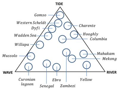
In line with the above description, estuaries can be classified according to the criteria “tide-dominated”, “wave-dominated” and “river-dominated”. Because many estuaries fall in between these criteria, a scale indicating the relative importance of these criteria is often used, as shown in the triangle diagram [16] of figure 4. Morphologic characteristics of particular estuaries indicated in this figure are discussed below.
The diagram of figure 4 is a qualitative classification tool, not based on quantifiable parameters. Tidal influence can be quantified in terms of tidal range, but the spring-neap tidal variation and the ratio tidal-range-to-depth are also relevant. Wave influence can be quantified by significant wave height. But the significant wave height is variable and periods of very high waves play a major role. The same holds for the wave incidence angle and wave period. River influence can be quantified in terms of mean river discharge, but the discharge variation is at least as relevant. Often more important are even the fluvial sediment discharge and the sediment characteristics. There is no obvious small set of parameters that can be used to quantify the relative influence of tides, waves and river discharge on estuarine morphology [17]. The positioning of estuaries in the classification diagram is thus primarily a matter of expert judgment. The examples discussed below also show that estuaries which are close in the diagram can be rather different. The classification tool should thus be used with care and only provides a rough indication of estuarine morphological characteristics.
Estuarine morphology: examples
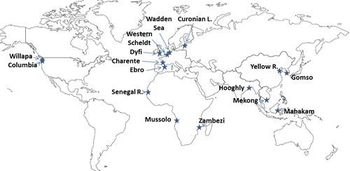
Particular estuarine systems, indicated in figure 4, are discussed below. Figure 5 shows the location of these systems on a world map. The selected estuarine systems illustrate morphologies observed in nature for different ratios of the relative influence of tide, waves and river discharge. Differences in estuarine morphology are observed depending on the relative importance of the three criteria tide-dominated, wave-dominated and river-dominated, as described above. The examples further show that tide influence, wave influence and river influence depend on many factors, that all need to be taken into account.
Besides natural forcing agents, engineering interventions (river damming, water diversion, channel dredging, land reclamation) have a profound influence on estuarine morphology. Estuaries which have been completely modified by engineering works are not considered here. However, many of the systems discussed below experience – and will experience in the near future - important morphological change, due to human interventions of the past decades and due to accelerated sea-level rise.
The examples represent a small minority of existing estuarine systems. Therefore, for each example a few other estuarine systems are indicated that can be considered similar from a morphological point of view.
In all the satellite images below the North is toward the top of the figure.
Charente estuary
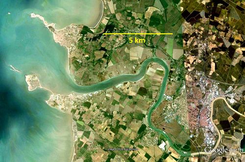
The Charente [18][19] (figure 6) is a tide-dominated estuary on the Atlantic coast of France, with a mean spring tidal range of 5 m. It is sheltered from ocean waves by several large offshore islands. The channel width at the mouth is about 500 m and the average channel depth about 6-7 m. The maximum spring-tidal velocity in the inlet channel is 0.8 m/s, averaged over the channel cross-section. The average river discharge is 70 m3/s; the corresponding river flow velocity is small compared to the tidal velocities. Peak runoff may exceed 600 m3/s.
The estuary planform exhibits the characteristic funnel shape; the width convergence length is about 10 km. The tide is thus hardly influenced by the weir 50 km upstream. Intertidal areas were partly reclaimed in the past, but the estuary was less severely modified than other similar European estuaries. The tidal wave is substantially distorted when propagating upstream along the estuary. During spring tides, the difference of ebb and flood duration increases along the estuary by more than an hour. As a consequence, maximum flood velocities are higher than maximum ebb velocities at the inner estuary. During neap tides the tidal wave is distorted less, with longer flood duration than ebb duration and smaller flood velocities than ebb velocities.
In periods of medium-low runoff, the Charente estuary is very turbid, with suspended sediment concentrations in excess of 1 g/l and peak values larger than 5 g/l at 1 m above the bed during spring tide. The estuarine turbidity maximum is related to estuarine circulation and tidal asymmetry. Tidal asymmetry favours trapping of suspended sediment during spring tides due to the dominance of flood velocities over ebb velocities and due to a shorter period of low-water slack tide compared to high-water slack tide: sediment brought in suspension by the ebb current is transported upstream by the flood current before settling takes place. During periods of high turbidity the friction experienced by tidal currents is strongly reduced due to the presence of fluid mud patches covering the channel bed.
Similar processes are observed in other tide-dominated estuaries such as the Loire, Weser and Ems.
Columbia River estuary
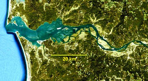
The Columbia River estuary [20] [21][22] (figure 7) developed within a drowned river valley, which imposes constraints on the estuary planform. However, the large width of the valley leaves substantial space for the development of morphological features typical for an estuarine environment, such as meandering and braiding river channels, bars, tidal flats and marshes. The intertidal area covers about 20% of the estuarine basin. Without land reclamation that occurred in the past, the intertidal area would be several times larger. The construction of jetties, which started already in the 19th century, has strongly reduced the width of the estuarine mouth, from about 9 km to 3.5 km at present. In the inner basin, the estuarine width displays upstream convergence, as observed usually in estuaries where tidal currents are much stronger than the river-induced current velocity. The mouth region is the deepest part of the estuary with channel depths of about 20 m. The average depth of the inner basin is about 8 m and influenced by dredging works. Estuarine morphodynamics are influenced by tides, waves and river runoff. The average river discharge is 5000-6000 m3/s, with peaks up to 12000 m3/s; higher peaks occurred in the past, before the construction of river dams. The river carries yearly about 10 million tons of sediment into the estuary, mostly fine sand and coarse silt.
The ocean tides are of the mixed type, with a strong diurnal component. The spring-tidal range is about 2.5 m. The relative phases of the M2, O1 and K1 tidal constituents induce tidal asymmetry at the mouth with faster tidal fall than tidal rise [23]. This favours ebb currents over flood currents and export of sediment.
The mouth region is strongly influenced by wave action. The significant height of ocean waves is about 3 m in the winter season, with a period of around 10 s. Although waves are most frequently incident from a west-north-westerly direction, the most energetic waves are from a west-south-westerly direction. Net littoral drift is therefore to the north. High waves from the south-west favour sediment import. Because of tectonic uplift, the relative sea level is more probably lowering rather than rising. Morphodynamic equilibrium then requires that net sediment export through the mouth exceeds the fluvial sediment import into the estuary.
Other estuaries in wide drowned river valleys are the Delaware (US), San Francisco Bay (US) and the Mersey (UK). Their morphological characteristics are similar, although they are less influenced by waves. The Mersey has a much larger tidal range (5 -10 m).
Curonian Lagoon
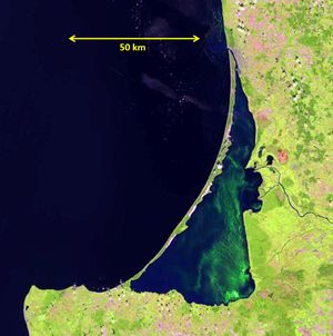
The Curonian lagoon [24] [25] [26] (figure 8), also known as Kurisches Haff, is separated from the Baltic Sea by a narrow sand spit of almost 100 km length. At the northern tip the lagoon is connected to the Baltic Sea by the Klaipeda Strait. The lagoon is on average about 4 m deep. The Klaipeda Strait has been dredged to a depth of around 10 m. There is almost no tidal motion in the Baltic Sea. Fresh water discharge into the lagoon (mainly from the Nemunas river) is on average about 700 m3/s. The salinity in the lagoon is therefore lower than in the Baltic Sea, where the average salinity is about 7 psu. Flushing of Curonian lagoon waters depends mainly on fresh water inflow and large-scale wind-driven circulation inside the lagoon. The residence time of lagoon waters is of the order of half a year.
The sand spit is subject to wind waves generated in the Baltic Sea. The highest waves are coming from the west (about 20% of the time), with heights between 1 and 2 m and period of 7 s and more. These high waves from the west induce a net littoral drift along the spit from west to east. The development of the sand spit started around 8000 BP, when the sea transgressed the Pleistocene floor of the present lagoon. Sand supply by littoral drift kept the spit crest above sea level. Part of the spit is covered with high sand dunes, which prevent overwash by storm waves. The lagoon drowned because the basin behind the spit raised at a slower pace than sea level (by sediment infill and isostatic uplift). Observations indicate that the Curonian spit is broadly in equilibrium with present relative sea-level rise.
Lagoons with similar characteristics are ubiquitous along wave-dominated microtidal coasts, for example the US Gulf coast (Corpus Christie Bay, Galveston Bay, Mobile Bay) and the US Atlantic coast (Pamlico Sound, Great South Bay).
Dyfi estuary
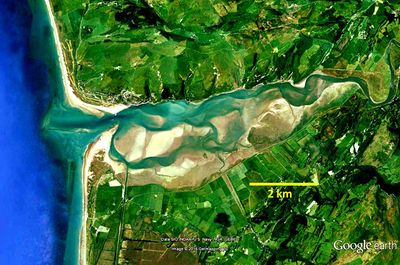
The Dyfi estuary [27] [28] [29] (figure 9), situated at the west coast of Wales, has developed by marine transgression and infilling of a wide former river valley. The estuary exhibits typical characteristics of a wave-dominated inlet and a tide-dominated inner basin. Fresh water inflow in the basin is small, 30 m3/s on average. The estuary is sandy (medium grain size about 0.25 mm) with a meandering channel system and extensive tidal flats. The average channel depth is 4-5 m and the overall depth 1-2 m.
The mean spring tidal range at the inlet is 4 m; rising tide has a shorter duration than falling tide. Flood currents are stronger than ebb currents in the inner basin. However, the inlet channel is ebb dominated due to a strong ebb jet.
High waves (wave height exceeding 3 m) occur about 5% of the time; the incidence angle is predominantly from western and south-western directions. This results in a northward littoral drift, responsible for the development of the sand spit at the southern inlet boundary. The inlet channel is therefore narrow and kept in a northern position. Net tidally-induced sediment transport in the inlet channel is directed seaward. This sediment loss from the estuary is probably compensated by sediment supply through wave-driven and tide-driven transport in the breaker zone along the southern spit and the northern channel boundary.
Ebro delta
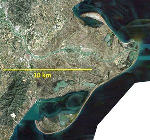
The Ebro delta on the Spanish Mediterranean coast (figure 10) is a typical example of a wave-dominated river delta [30] [31]. Tidal motion is almost absent. The delta was formed during the past millennia when the runoff sediment load of the Ebro River was high. Due to dam construction on the upper river starting around 1950, the sediment load was reduced more than tenfold, to about 1 million ton/year at present. The average water discharge decreased from 600 m3/s to about 400 m3/s, while peak discharges were more than halved, to about 3 times the average discharge. The reduction of the fluvial discharge had important consequences for the delta morphology. A single outlet channel has remained, with bankfull width and depth of 180 m and 5 m, respectively. The sand fraction was scoured from the top layer of the outlet channel, leaving a coarse (“armoured”) sediment bed.
The river mouth is retreating several tens of meters per year. The delta has become more wave dominated with less fluvial influence. Most frequent and highest waves are coming from easterly directions, with average height of about 1 m and period of 5 s; wave heights of 2-3 m occur exceptionally. The corresponding wave-induced littoral drift produces lateral spread of the delta front to the south and to the north. The delta lobes contain reworked deposits of ancient avulsed outlet channels.
In periods of low to medium river discharge, seawater intrudes the outlet channel as a salt wedge. The length of the salt wedge is determined not only by river discharge, but also by the presence of sills (hard outcrops) in the channel bed. A more detailed discussion is presented in Salt wedge estuaries.
Deltas with similar characteristics include the Danube, Rhône and Po.
Gomso Bay
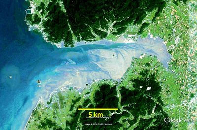
Gomso Bay is a macrotidal basin on the west coast of South Korea [32] [33] (figure 11). The tide is semidiurnal; the average tidal range is 4.6m (maximum 8m). River inflow is very small. The basin has a funnel-shaped morphology, characteristic for macrotidal inlets. The water depth of the main channel reaches 20m during spring tide. The maximum ebb current (about 1.5 m/s) is stronger than the maximum flood current. The inner basin is tide-dominated, with large bare tidal flats. The tidal flats have typically an upward convex profile; they are muddy and strongly reworked by bioturbation.
The outer bay is wave dominated with large muddy concave-up tidal flats. Significant offshore wave heights during winter are 2–4 m. The middle part of the basin has sandy channels and shoals.
Macrotidal inlets with similar morphology include Baie de la Somme (France), Morecambe Bay (UK), the estuaries of the Ribble and Dee (UK), Haeju Bay (North Korea) and Baia de Sofala (Mozambique). The Baie du Mont St.Michel (France) with a mean spring tidal range of 10 m has also similar morphologic characteristics; however, the channels in the Baie are very shallow and highly mobile due to the particular type of sediment (“tangue”, non-cohesive fine bioclastic material).
Hooghly estuary
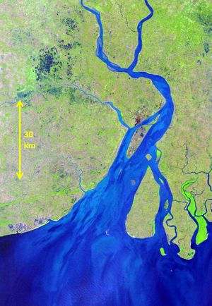
The Hooghly [34] [35] [36][37] is the most western branch of the Ganges-Brahmaputra delta (figure 12). The average river discharge is estimated at 3500 m3/s, with a yearly peak of 12000 m3/s. The significant wave height at the mouth is rather small - about 0.6 m. The estuary has the characteristic funnel shape. The channel width reduces from 20 km at the mouth to about 6 km at a distance 40 km upstream. The channel depth along the thalweg is about 10-15 m; the width-averaged depth is much lower, about 6-8 m.
The estuary is tide-dominated with a mean spring tidal range of 4 m. The tidal range increases by some 20% over the first 60 km of the estuary. The speed of the tidal high water (HW) propagating into the estuary is about 10 m/s, which is faster than the 7 m/s speed of the tidal low water (LW). At Kolkota, 140 km from the mouth, the period of tidal rise is almost 4 hours shorter than tidal fall. Peak flood currents are therefore substantially stronger than peak ebb currents. At high spring tides a tidal bore develops 50 km downstream from Kolkota. The sediment discharge to the sea is of the order of 20 million ton/year. The estuary is moderately turbid, with surface concentrations of suspended sediment of a few hundred mg/l in the upper estuarine zone and concentrations less than 100 mg/l at the mouth. The upper estuary limit corresponds to the tidal intrusion front, which is located 70-80 km upstream from the mouth.
Estuaries with similar characteristics include the Meghna estuary (Bangladesh), Amazon estuary (Brazil), Fly estuary (New Guinea) and Yangtze estuary (China).
Mahakam delta
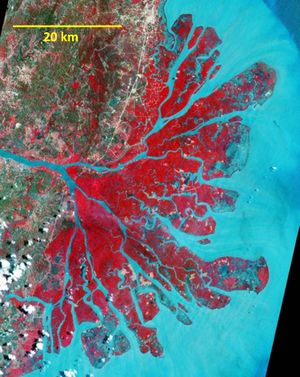
The Mahakam [38] [39] [40] [41] is a large tropical river of Kalimantan (Borneo) flowing into the Makassar Strait (figure 13). The river discharge near the delta apex (channel width 500-1000 m, depth 5-10 m) is typically in the range 2000-3000 m3/s. Peak discharges are buffered by large inland lakes. River flow velocities may reach 1.5 m/s. The channel bed along the thalweg consists of consolidated clays. The river has built a large delta, with three main distributaries, which divide over a large number of smaller delta branches. Mouth bars are present at the seaward boundaries of the different distributaries. The depth of the distributaries ranges between 2 and 6 m. Fine sand deposits prevail in the southern delta lobes, while organic mud deposits (interbedded with fine sand) are found in the less active northern branches.
The tidal range in the Makassar Strait is small, between 1 and 2 m. Yet many large funnel-shaped tidal creeks are visible in the satellite image. Tidal currents dominate in the delta branches. Maximum tidal velocities are of the order of 1 m/s. Tidal influence is enhanced by subsidence of the delta.
Mekong delta
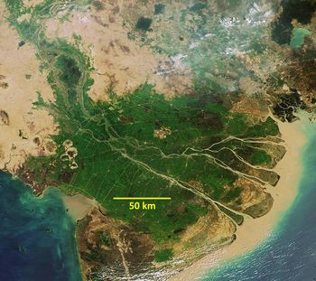
The Mekong delta [42] [43] [44] [45][46] (figure 14) is among the largest floodplains of the world. The present delta developed during the past 8000 years by the high sediment discharge of the Mekong river, which is estimated at 50-150 Mton/year. Most of the sediment load consists of fine silt. The present sand export to the sea is estimated at 5-9 Mton/year [47]. Initial progradation rates of 20-30 m/year have decreased to 10-20 m/year during the past millennia. The upper part of the delta was formed during the mid-holocene equatorial high-stand (6000 BC) when the sea level was 2.5-4.5 m higher. The delta built out mainly in southern direction, due to an important southward littoral drift. This littoral drift is related to longshore currents (up to 0.55 m/s) and waves (significant wave height of 1.7 m), generated by the strong NE winter monsoon. The largest progradation occurs at the Cap Camau peninsula, some 200 km south of the river mouth. The lower river delta has a well-developed system of beach ridges (low dunes of 3-10 m high) with inter-ridge swamps and mangrove marshes. The subaerial delta is approximately 10 km wide and fronted by a steep subaqueous delta.
The average fresh water discharge of the Mekong is about 15,000 m3/s with peaks of 40,000 m3/s. Two main distributaries (Bassac and Mekong) split in the lower delta into several sub-branches. The largest sub-branch is the Dinh An (northern branch of the Bassac river), which takes almost 30% of the total river runoff. The tidal channels are wider at the mouth than upstream, but the width convergence length is large – about 80 km. The average channel depth is about 7 m at the mouth and 12 m further upstream (Dinh An channel).
The lower delta is under tidal influence. The tide is mainly semidiurnal (M2) with an important diurnal component (K1). The mean tidal range is 2 m and the spring-tidal range 3 m. In periods of low river runoff, peak flood velocities in the Dinh An channel reach 1 m/s and are about 10% higher than peak ebb velocities. Sediment (fine sand and mud) is trapped in the estuary; suspended concentrations reach 0.5 g/l. The sediment grain size is of the order of 0.2 mm. The tidal salinity front moves some 50 km up the estuary during the dry season. During high river flow, suspended sediment concentrations are below 0.1 g/l and seawater is almost completely expulsed from the estuary.
The Indus delta (Pakistan) has characteristics comparable with the Mekong; tide, wave height and solid discharge are similar, but the water discharge is much lower and the suspended load much higher.
Mussulo Lagoon
The rectangular Mussulo Lagoon [48] (figure 15) is situated on the Atlantic coast of Africa, near Luanda. The average tidal range is 1 m (maximum 1.8 m). Sea breeze is the most common wind. Northward sand transport along the coast (in the order of 0.1 Mm3/year, decreasing to the north) is driven by frequent swell waves from the SW with a significant height of 1–1.5 m. The length of the sand barrier separating the lagoon from the ocean has decreased during the past century. A large shoal north of the entrance to the lagoon is a remainder of the previously longer sand spit. The lagoon is sandy without mudflats; tidal flats are sparsely vegetated. The lagoon is situated in an arid region; it receives no fresh water runoff and little organic matter. Distinct ebb and flood channels are bending around tidal flats, which are intersected by shortcut channels.
Other similar lagoons exist along the Persian Gulf coast (Al Jubail, Abu Dabi), and the coast of Tanzania (Lazy Lagoon).
Tidal lagoons of similar dimensions and with similar tidal range and wave climate occur along many microtidal coasts in temperate and subtropical regions. The intertidal zones of these lagoons are covered with densely vegetated marshes, which reduce channel migration dynamics. The production of organic material contributes to raising the intertidal zones in order to keep pace with sea-level rise. Examples are the Venice lagoon and lagoons along the southern US Atlantic coast.
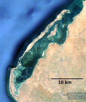
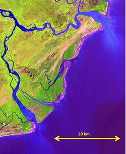
Senegal River delta
The Senegal River [49] [50] [51] [52] (figure 16), situated on the African Atlantic coast, has a wave dominated delta. A strong littoral drift from north to south shifted the river mouth from its original position (outcrop at the top of the figure) more than 40 km to the south. A narrow sand spit, called “Langue de Barbarie” (less than 1 km wide and less than 5 m high) separates the river from the ocean over a distance of 30 km. The spit has breached several times during the last century. After each breach, the mouth migrated southward with a speed of about 400 m/year, to reach a position close to the 2003 position shown in the figure.
The average discharge of the Senegal River is 600-700 m3/s; during several months each year the discharge is almost nil, whereas peak discharges can exceed 2000 m3/s. Spit breach occurred in the past for extreme river discharges. The average sediment runoff of the Senegal River is about 1 million ton/year; most of the sediment consists of fine silt and clay minerals with grainsize of around 0.005 mm and less. The average channel depth of the lower Senegal river is 6-7 m.
Tides are small; the spring tidal range hardly exceeds 1 m. Ocean waves are coming most of the time from north-western directions. The average wave height is 1.4 m and the wave period about 5 s; wave heights up to 5 m occur exceptionally. A wave- and wind-driven current of 0.3 m/s on average flows along the shore in southward direction; the littoral drift is estimated at 0.5-1 million m3/year. Sand is supplied by the former delta and by shoreward migrating Sahara dunes further northward.
In 2003 the sand spit was breached artificially, to prevent flooding of the town of Saint-Louis (situated at the northern root of the spit) by a high river flood wave. The artificial breach was initially less than 5 m wide and increased to more than 5 km wide in the next 10 years. The southward migration of the new river mouth is not as fast as for previous breaches. Increase of tidal motion, due to tidal wave reflection at the Diama dam built 25 km upstream of Saint-Louis (1986), might be one of the causes.
The Senegal River delta is an extreme example of an alongshore migrating river delta due to littoral drift; another example is the Mono River Delta (Benin). There are many less extreme examples of such deltas, for example the Mahanadi River Delta (India) and the Volta River Delta (Togo).
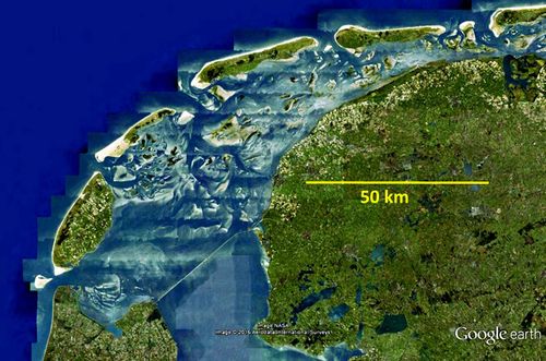
Wadden Sea
The Wadden Sea [53] [54] (figure 17) is a series of tidal lagoons along the tide- and storm-dominated Dutch-German-Danish North Sea coast. The lagoons developed by marine transgression around 6000 BP of the west- and north-Frisian Pleistocene plain. Breaches of the initial coastal barrier gave rise to numerous tidal lagoons sheltered by barrier islands and mutually separated by submergible tidal divides. The tidal range increases along the coast from about 2 m in the west to 3.5 m in the east. All the lagoons have pronounced ebb-tidal deltas. The largest lagoons occur in the western part of the Wadden Sea. The figure shows the tidal lagoons of the Western Wadden Sea of the Netherlands – from west to east: Texel Inlet, Eijerland Inlet, Vlie Inlet, Ameland Inlet and Frisian Inlet.
The Wadden lagoons are sandy systems, with mostly fine sands (0.1-0.2 mm). The mud fraction (d < 16μ) of the bed top layer (25 cm) is generally low (higher at the end of the summer than at the end of the winter). Even on the highest parts of the tidal flats the mud fraction almost never exceeds 10% and the average fraction is only a few %. Only the most landward part of the tidal flats is vegetated (Salicornia dolichostachya, Spartina anglica). The channel depth is about 15-20 m at the inlets and 4–10 m in the inner basins. The channel system is fairly stable and has a ‘normal’ configuration: Tidal flats are situated at the inner channel bends; channel branches shoot off at the outer channel bends; the strongest curvature occurs where the outer bend meets a boundary.
The maximum spring tidal currents are of the order of 1.5 m/s at the inlet throat and of the order of 1 m/s in the interior channels. Cross-sectionally averaged velocities are about 30% lower. Peak channel currents are slightly stronger during flood than during ebb. Sand from the North Sea enters the Wadden Sea inlets. The net yearly import in the Western Wadden Sea is of the order of 6 Mm3 (average over the period 1935-2005) [55]. This is a little more than needed for keeping pace with sea-level rise (15–20 cm over the past century).
All the Wadden Sea inlets have large ebb-tidal deltas. The ebb-delta shoals migrate along the inlet and the orientation of the main ebb channel varies accordingly. The channel-shoal pattern therefore evolves in a cyclical way, with periodicity depending on the tidal volume of the back-barrier basin[56].
Texel Inlet is the main inlet of the former Zuyderzee, which was dammed off in 1930. Bathymetric surveys indicate that the rate of infilling was very high the first decades after closure, but it has strongly decreased since[55]. Most of the imported sand was taken from the ebb-tidal deltas. The sand volume stored in each ebb-tidal delta was comparable to the volume of the corresponding lagoon. After closure of the Zuyderzee the sand volumes of the Texel and Vlie ebb-tidal deltas have strongly decreased.
A tidal lagoon system similar to the Wadden Sea exists at the southern Algarve coast of Portugal.
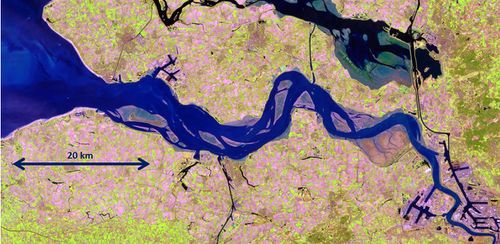
Western Scheldt and Scheldt estuary
The Western Scheldt – Scheldt estuary [57] [58] [59] (figure 18) is a meso-tidal basin (4 m tidal range), with small river inflow (average 100 m3/s). Wave influence is substantial only at the inlet zone. The seaward part is a wide sandy lagoon, which developed around 1500 BC in the Rhine-Meuse-Delta coastal plain after breaching of a former coastal barrier. Tidal currents scoured a system of multiple ebb- and flood-dominated channels, separated by shoals. The average depth is about 16 m; depths up to 40 m occur at outer channel bends. The intertidal area, which covered in the past more than 3000 ha was reduced by reclamation to less than 1000 ha; reclaimed land is protected by seadikes. The estuary has now a converging shape: width 4-6 km wide at the mouth, decreasing to about 2 km at 80 km upstream.
The river Scheldt enters the Western Scheldt basin at the Dutch-Belgian border; in the past, the river Scheldt was connected to the sea through the more northerly situated Eastern Scheldt basin. The Scheldt is a tidal river, heavily dredged to allow shipping to the harbour of Antwerp (depth navigation channel of 15 m). The tidal channel has a funnel shape: from 1500 m wide at the Dutch-Belgian border to about 300 m, 30 km upstream. The tidal range is highest (5.5 m) in the fresh-salt transition zone near Antwerp. Tidal motion remains substantial more than 100 km further upstream.
Several estuaries with similar characteristics exist in Western Europe: Elbe, Weser, Ems, Humber, Seine, Loire. All these estuaries were strongly modified during the past century for navigation purposes (channel deepening, tidal flat reclamation, infill of secondary channels). The Delaware, Potomac and James River are estuaries with comparable characteristics in the US.
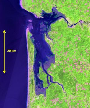
Willapa Bay
Willapa Bay [60] [61] [62] (figure 19) is a rectangular shaped tidal lagoon, sheltered from the Pacific Ocean by a 27 km long sandy spit. The entrance channel situated at the north of the basin is shifted further northward by littoral drift and wave- and current-induced erosion of the northern inlet border. The conditions at the inlet are similar to those at Columbia River mouth, situated 50 km to the south. Highest waves (heights exceeding 10 m with periods of 10-20 s) from a south-westerly direction occur during winter, whereas lower waves from the north-west dominate in other seasons. The inlet channel has a sand-gravel bed; the depth exceeds 20 m. The inner basin is dissected by a network of channels with a substrate of fine sand interbedded with mud; the depth is less than 10 m. About half of the lagoon area consists of mudflats and marshes with a silt-clay substrate.
The average fresh water inflow is less than 100 m3/s, which is very small compared to the tidal discharges. The tide is semidiurnal (M2) with strong diurnal components (K1, O1); the relative phases favour a longer duration of tidal rise compared to tidal fall. The mean spring-tidal range is 3.5 m. The maximum velocity of tidal currents is 1 m/s; ebb currents in the channels are stronger than flood currents. The tidal flats are flood dominated. The net flow over the tidal flats is flood directed, whereas the net flow in the channels is ebb directed. The tidally averaged sediment flux is seaward. However, sand import into the lagoon is observed under storm conditions.
The Bassin d’Arcachon on the French Atlantic coast has morphologic characteristics similar to those of Willapa Bay.
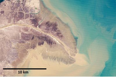
Yellow River delta
The Yellow River [63] [64] (Huanghe, figure 20) has the highest suspended sediment concentration of all rivers in the world: about 20 g/l on average and 200 g/l during peak flow. The sediment load consists of silt (grainsize of around 0.01 mm and less) originating from the large loess plateau at the upper reaches of the river. In the past, sediment runoff was of the order of 1000 Mton/year and the average water discharge close to 2000 m3/s. The river runoff and sediment load to the sea have strongly decreased during the past decades to about 20% for the river runoff and about 15% for the sediment discharge, by irrigation works and the construction of water reservoirs. The major proportion of the sediment load is discharged offshore.
The course of the lower Yellow River has changed several times, due to siltation and clogging of the river outflow channel. Since the mid-19th century, the Yellow River discharges into the Bohai Sea. The delta has typically a single branch, because siltation prevents the existence of a multi-channel delta.
The tidal range is very small (about 1 m) because the river mouth coincides with an amphidromic point of the tidal system in the Bohai Sea. Alongshore tidal currents are substantial; they can reach 1 m/s. During high river runoff the outflow plume of the Yellow River has a higher density than seawater; the plume plunges along the submarine slope as a turbidity current (hyperpycnal flow). Under moderate river flow, the outflow plume is diverted along the coast by tidal currents. Sediment is deposited within a distance of less than 15 km from the river delta. The delta area expanded yearly on average by 10-20 km2; at present, this expansion has almost stopped.
The Mississippi delta expands in a way similar to the Yellow River delta, by accretion around the tip of the river outflow channel. However, the sediment load of the Mississippi is much lower. Hence, several outflow channels co-exist, responsible for the “bird-foot” shape of the Mississippi delta. Both deltas subside due to the weight of sediment deposits; in both cases this subsidence is accelerated by oil extraction.
Zambezi River delta
The Zambezi [65] [66] [67] (figure 21) is the largest river of East Africa, with an average discharge of about 3000 m3/s. The discharge variability was strongly reduced after the construction of river dams upstream; since 2003 the discharge fluctuates seasonally between 1500 and 4000 m3/s. The sediment discharge is estimated at 40±10 Mm3/year. The delta has a large dune area vegetated with grassland and shrubs. The seaward delta fringe, which is flooded at high river runoff, is covered with mangrove forest; mudflats occur at the seaward side.
The tide is semidiurnal; the mean spring-tidal range is about 4 m. The channels of the two main distributaries have a funnel-shaped mouth, indicative of strong tidal influence. Tidal influence is felt up to 80 km upstream at low river discharge. Tidal currents reach 1.5 m/s near the estuarine mouth during spring tide, which is almost an order of magnitude larger than the river flow velocity. The channels near the entrance are nevertheless very shallow. The deepest channel has a depth of about 5 m and elsewhere depths are between 2 and 4 m. The estuarine delta morphology is highly variable, with meandering and braiding channels and migrating sandbanks.
The morphodynamics of the mouth region is influenced by wave action. The significant wave height is 1.3 m (peak period 7 s) and the dominant wind direction is from the south-east, producing a substantial northward littoral drift. This is illustrated by the channel orientation of the smaller distributaries. South of the large northern Chinde inlet the coastline has prograded about 2 km during the last 40 years.
The Niger delta (Nigeria) and the Godavari delta (India) have morphological characteristics similar to the Zambezi delta. They are also influenced by river discharge, tides and waves, but the tidal influence is less (tidal range of about 2 m).
Related articles
- Tidal asymmetry and tidal basin morphodynamics
- Ocean and shelf tides
- Salt wedge estuaries
- Wave-dominated river deltas
- Estuarine circulation
- Definitions, processes and models in morphology
- Classification of coastlines
- Coastal and marine sediments
- Seawater intrusion and mixing in estuaries
- Physical processes and morphology of synchronous estuaries
- Estuarine morphological modelling
Further reading
Colin Woodroffe (2002) Coasts, form, processes and evolution. Cambridge Univ. Press, 623 pp.
David Prandle (2009) Estuaries. Dynamics, Mixing, Sedimentation and Morphology. Cambridge University Press, 248 pp.
Treatise on Estuarine and Coastal Science (2011) Eric Wolanski and Donald McLusky (Editors), Elsevier
References
- ↑ Dronkers, J. (2016) Dynamics of Coastal Systems 2nd edition. World Scientific Publ. Co.
- ↑ Dalrymple, R.W. and Choi, K. (2007) Morphologic and facies trends through the fluvial–marine transition in tide-dominated depositional systems: A schematic framework for environmental and sequence-stratigraphic interpretation. Earth-Science Reviews 81: 135–174
- ↑ Van Veen, J. 1950. Eb- en VIoedschaar Systemen in de Nederlandse Getijwateren. Tijdschrift Koninklijk Nederlandsch Aardrijkskundig Genootschap 67: 303-325. Annotated English translation published by Van der Spek, A., Stive, M. and Zitmans, T. (2001) Publ. Delft University.
- ↑ Levoy, F., Anthony, E.J., Dronkers, J., Montfort, O., Izabel, G. and Larsonneur, C. (2017) Influence of the 18.6-year lunar nodal tidal cycle on tidal flats: Mont-Saint-Michel Bay, France. Marine Geology 387: 108–113
- ↑ Dronkers, J. (2017) Convergence of estuarine channels. Continental Shelf Res. 144: 120–133
- ↑ O'Brien, M.P. (1969) Equilibrium flow areas of inlets and sandy coasts. J.Waterw.Harbor Coast.Eng.Div. 95: 43-52
- ↑ Friedrichs C.T. 1995. Stability shear stress and equilibrium cross-sectional geometry of sheltered tidal channels. J.Coast.Res. 11: 1062-1074
- ↑ Postma, H. (1967) Sediment transport and sedimentation in the estuarine environment. In: Estuaries. Ed.: G.H.Lauff, Am.Ass.Adv.Sci. 83, Washington, D.C.: 158-179
- ↑ Friedrichs, C.T. (2011) Tidal Flat Morphodynamics: A Synthesis. In: Treatise on Estuarine and Coastal Science, vol. 3, Estuarine and Coastal Geology and Geomorphology. Ed.:J. D. Hansom and B. W. Fleming, Elsevier, Amsterdam: 137-170
- ↑ Fagherazzi, S., Carniello, L., DAlpaos, L. and Defina, A. (2006) Critical bifurcation of shallow microtidal landforms in tidal flats and salt marshes. Proc. Natl. Acad. Sci. U. S. A., 103(22): 8337- 8341
- ↑ Kraus, N.C., Patsch, K. and Munger, S. (2008) Barrier beach breaching from the lagoon side, with reference to Northern California. Shore and Beach 76: 33-43
- ↑ Nienhuis, J.H. (2016) Plan-view evolution of wave-dominated deltas. PhD thesis, Twente University
- ↑ Geleynse, N., Storms, J.E.A., Walstra, D-J., R., Albert Jagers, H.R., Wang, Z.B. and Stive, M.J.F. (2011) Controls on river delta formation; insights from numerical modelling. Earth and Planetary Science Letters 302: 217–226
- ↑ Yu, Q., Wang, Y., Gao, S., Flemming, B. (2012) Modeling the formation of a sand bar within a large funnel-shaped, tide-dominated estuary: Qiantangjiang Estuary, China. Marine Geology 299-302: 63-76
- ↑ Fitzgerald, D., 1988. Shoreline erosional-depositional processes associated with tidal inlets. In: Aubrey, D., Weishar, L. (Eds.), Hydrodynamics and Sediment Dynamics of Tidal Inlets. Springer Verlag, Berlin, pp. 186–225
- ↑ Galloway, W.E. (1975) Process framework for describing the morphologic and stratigraphic evolution of deltaic depositional systems. In: Broussard ML (ed) Deltas: models for exploration. Houston Geological Society, Houston, pp 87–98
- ↑ Perillo, G.M.E. (1995) Definitions and geomorphologic classifications of estuaries. In: Geomorphology and Sedimentology of Estuaries. Ed., G.M.E. Perillo. Elsevier, Amsterdam, pp. 17–47
- ↑ Toublanc, F., Brenon, I., Coulombier, T. and LeMoine, O. (2015) Fortnightly tidal asymmetry inversions and perspectives on sediment dynamics in a macrotidal estuary (Charente, France). Continental Shelf Res. 94: 42–54
- ↑ Toublanc, F., Brenon, I. and Coulombier, T. (2016) Formation and structure of the turbidity maximum in the macrotidal Charente estuary (France): Influence of fluvial and tidal forcing. Estuarine, Coastal and Shelf Science 169: 1-14
- ↑ Sherwood, C.R., Jay, D.A., Harvey, R.B., Hamilton, P. and Simenstad, C.A. (1990) Historical changes in the Columbia River Estuary. Progress in Oceanography 25: 299-352
- ↑ Gelfenbaum, G. (1983) Suspended-sediment response to semidiurnal and fortnightly tidal variations in a mesotidal estuary: Columbia river. Marine Geology 52: 39-57
- ↑ Moerman, E. (2011) Long-term morphological modelling of the mouth of the Columbia River. PhD Thesis, Delft University
- ↑ Nidzieko, N. J. (2010) Tidal asymmetry in estuaries with mixed semidiurnal/diurnal tides, J. Geophys. Res., 115, C08006, doi:10.1029/2009JC005864
- ↑ Gelumbauskaite, L.Z. (2002) Holocene history on the northern part of the Curonian Lagoon. Baltica 15: 3-12
- ↑ Umgiesser, G., Zemlys, P., Erturk, A., Razinkova-Baziukas, A., Mezine, J. and Ferrarin, C. (2016) Seasonal renewal time variability in the Curonian Lagoon caused by atmospheric and hydrographical forcing. Ocean Sci. 12: 391–402
- ↑ Kelpsaite, L., Dailidiene, I. and Soomere, T. (2011) Changes in wave dynamics at the south-eastern coast of the Baltic Proper during 1993-2008. Boreal Environment Research 16A: 220-232
- ↑ Robins, P.E. (2009) Development of a morphodynamic model of the Dyfi Estuary to inform future management decisions. CAMS Report: CAMS 2009-4, Centre for Applied Marine Sciences, Bangor University
- ↑ Robins, P.E. and Davies, A.G. (2010) Morphodynamic processes in shallow estuaries: influence of tidal flats and channels on sand transport. Ocean Dynamics 60: 503-517
- ↑ Brown, J.M. and Davies, A.G. (2009) Methods for medium-term prediction of the net sediment transport by waves and currents in complex coastal regions. Continental Shelf Research 29: 1502–1514
- ↑ Nienhuis, J.H. (2016) Plan-view evolution of wave-dominated deltas. PhD thesis, Twente University
- ↑ Ibanez, C., Pont, P. and Prat, N. (1997) Characterization of the Ebre and Rhone estuaries: A basis for defining and classifying salt-wedge estuaries. Limnol. Oceanograph. 42: 89-10
- ↑ Choi, K. (2011) Tidal rhythmites in a mixed-energy, macrotidal estuarine channel, Gomso Bay, west coast of Korea. Mar. Geol. 280: 105–115
- ↑ Choi, K., Hong, C.M., Kimb, M.H., Oh, C.R. and Jung, J.H. (2013) Morphologic evolution of macrotidal estuarine channels in Gomso Bay, west coast of Korea. Implications for the architectural development of inclined heterolithic stratification. Mar. Geol. 346: 343–354
- ↑ Chugh, S. R. S. (1961) Tides in Hooghly River. International Ass. Sci. Hydrology Bulletin, 6(2): 10-26
- ↑ Mukhopadhyay, S. K. (2007) The Hooghly Estuarine System, NE Coast of Bay of Bengal, India. Workshop on Indian Estuaries, NIO, Goa June 2007
- ↑ Sadhuram, Y., Sarma, V. V., Murthy, T. V. R. and Rao, B.P. (2005) Seasonal variability of physico-chemical characteristics of the Haldia channel of Hooghly estuary, India. J. Earth Syst. Sci. 114: 37-49
- ↑ Banerjee, A.P., Dutta, S. and Majumdar, A. 2015. Quest for the determination of environmental flow assessment for hilsa fish of the Hooghly estuary by hydraulic rating method. ARPN Journal of Engineering and Applied Sciences 10: 7885-7899
- ↑ Allen, G.P. and Mercier, F. (1994) Reservoir facies and geometry in mixed tide and fluvial-dominated delta mouth bars: example from the modern Mahakam delta (East Kalimantan), Proc. Indonesian Petroleum Association, 23d Annual Convention 1994
- ↑ Lambiase, J.J. (2013) Sediment Dynamics and Depositional Systems of the Mahakam Delta, Indonesia: Ongoing Delta Abandonment On A Tide-Dominated Coast. Journal of Sedimentary Research 83: 503-521
- ↑ Andang Bachtiar, Joko Wiyono, Liyanto, Mohammad Syaiful, Yudi Satria Purnama, Muhammad Rozalli, Andi Krisyunianto and A.S. Purnama (2010) The Dynamics of Mahakam Delta - Indonesia, Based on Spatial and Temporal Variations of Grab Samples, Cores, and Salinity. Search and Discovery Article #50363. Online Journal for E&P Geoscientists
- ↑ Mandang, I. and Yanagi, T. (2008) Tide and tidal current in the Mahakam estuary, East Kalimantan. Coastal Marine Science 32: 1-8
- ↑ Ta, T.K.O., Nguyen, V.L., Tateishi, M., Kobayashi, I., Tanabe, S. and Saitoc, Y. (2002) Holocene delta evolution and sediment discharge of the Mekong River, southern Vietnam. Quaternary Science Reviews 21: 1807–1819
- ↑ Nowacki, D. J., Ogston, A. S., Nittrouer, C. A., Fricke, A. T. and Van Pham, D. T. (2015) Sediment dynamics in the lower Mekong River: Transition from tidal river to estuary. J. Geophys. Res. Oceans 120: 6363–6383
- ↑ Wolanski, E., Nhan, N. and Spagnol, S. (1998) Sediment dynamics during low flow conditions in the Mekong River Estuary, Vietnam. J. Coastal Res. 14: 472–482
- ↑ Xue, Z., Liu. J.P., DeMaster, D., Nguyen L.V. and Ta, T.K.O. (2010) Late Holocene Evolution of the Mekong Subaqueous Delta, Southern Vietnam. Marine Geology 269: 46–60
- ↑ Gugliotta, M., Saito, Y., Nguyen, V.L., Oanh Ta, T.K., Nakashima, R., Tamura, T., Uehara, K., Katsuki, K. and Yamamoto, S. (2017) Process regime, salinity, morphological, and sedimentary trends along the fluvial to marine transition zone of the mixed-energy Mekong River delta, Vietnam. Continental Shelf Res. 147: 7–26
- ↑ Stephens, J.D., Allison, M.A., Di Leonardo, D.R., Weathers III, H.D., Ogston, A.S., McLachlan, R.L., Xing, F. and Meselhe, E.A. (2017) Sand dynamics in the Mekong River channel and export to the coastal ocean. Continental Shelf Research 147: 38–50
- ↑ Dagniaux, M.F. (2013) Analysis of the Morphological Behaviour along the Luanda Coast. M.Sc. Thesis, Delft University
- ↑ Barusseau, J-P., Ba, M., Descamps, C., Diop, E.H.S., Kane, A., Saos, J-L. et Soumar, A. (1998) Morphological and sedimentological changes in the estuary Senegal river after the constuction of the Diama dam. Journal of African Earth Sciences, 26: 317-326
- ↑ Sy, A.A. (2013) Dynamiques sédimentaires et risques actuels dans l’axe Saint-Louis-Gandiol, littoral Nord du Sénégal. Thèse UGB, Saint-Louis, Senegal
- ↑ Boubou Aldiouma Sy, B.A. (2005) L’ouverture de la brèche de la Langue de Barbarie et ses consequences Approche géomorphologique. Univ. Gaston Berger/Sénégal
- ↑ Barry, K.M. et Kraus, N.C. (2009) Stability of Blocked River Mouth on West Coast of Africa: Inlet of Senegal River Estuary. USACE Report ERDC/CHL TR-09-20
- ↑ Oost, A.P., Hoekstra, P., Wiersma, A., Flemming, B., Lammerts, E.J., Pejrup, M., Hofstede, J., van der Valk, B., Kiden, P., Bartholdy, J., van der Berg, M.W., Vos, P.C., de Vries, S. and Wang, Z.B. (2012) Barrier island management: Lessons from the past and directions for the future. Ocean & Coastal Management 68: 18-38
- ↑ Wang, Z.B., Hoekstra, P., Burchard, H., Ridderinkhof, H., De Swart, H.E. and Stive,M.J.F. (2012) Morphodynamics of the Wadden Sea and its barrier island system. Ocean and Coastal Management 68: 39–57
- ↑ 55.0 55.1 Elias, E.P.L., Van der Spek, A.J.F., Wang, Z.B. and De Ronde, J. (2012) Morphodynamic development and sediment budget of the Dutch Wadden Sea over the last century. Neth. J. of Geosciences - Geologie en Mijnbouw 91: 293-310
- ↑ Ridderinkhof, W., Hoekstra, P., van der Vegt, M. and de Swart, H.E. (2016) Cyclic behavior of sandy shoals on the ebb-tidal deltas of the Wadden Sea. Continental Shelf Research 115: 14–26
- ↑ Van Veen, J. (1950) Eb-en vloedschaar systemen in de Nederlandse getijdewateren. Tijdschrift Kon. Ned. Aardrijkskundig Genootschap 67: 303–325
- ↑ Van der Spek, A.F.J. (1997) Tidal asymmetry and long-term evolution of Holocene tidal basins in The Netherlands: simulation of paleo-tides in the Schelde estuary. Mar. Geol. 141: 71–90
- ↑ Winterwerp, J.C. (2013) On the response of tidal rivers to deepening and narrowing; risks for a regime shift towards hyper-turbid conditions. Flemish-Dutch Scheldt Committee report, 83 pp.
- ↑ Lesser, G.R. (2009) An Approach to Medium-term Coastal Morphological Modelling. PhD thesis Delft University
- ↑ Morton, R.A., Clifton, H.E., Buster, N.A., Peterson, R.L. and Gelfenbaum, G. (2007) Forcing of large-scale cycles of coastal change at the entrance to Willapa Bay, Washington. Marine Geology 246: 24–41
- ↑ Mariotti, G. and Fagherazzi, S. (2011) Asymmetric fluxes of water and sediments in a mesotidal mudflat channel. Cont. Shelf Res. 31: 23-36
- ↑ Cui, B.L. and Li, X.Y. (2011) Coastline change of the Yellow River estuary and its response to the sediment and runoff (1976–2005). Geomorphology 127: 32–40
- ↑ Bi, N., Yang, Z., Wang, H., Hu, B. and Ji, Y. (2010) Sediment dispersion pattern off the present Huanghe (Yellow River) subdelta and its dynamic mechanism during normal river discharge period. Estuarine, Coastal and Shelf Science 86: 352–362
- ↑ Hoguane, A.M. (1999) Sea level measurement and analysis in the western Indian Ocean. National Report Mozambique, IOC, UNESCO. 34pp.
- ↑ Ronco, P., Fasolato, G., Nones, N. and Di Silvio, G. (2010) Morphological effects of damming on lower Zambezi River. Geomorphology 115: 43–55
- ↑ Environmental Resources Management Southern Africa Ltd and Impacto Associados Lda (Impacto) (2011) Riversdale’s Zambezi River Barging Project, Zambezi River, Mozambique. Final Environmental and Social Impact Assessment Report
Please note that others may also have edited the contents of this article.
|
