Integrating Climate Change into the ICZM planning process - Analysis and Future
| Introduction |
|
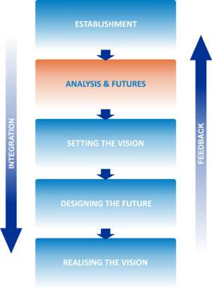
Establishment |
|
Analysis and Futures |
|
Setting the Vision |
|
Designing the Future |
|
Realising the Vision |
|
Contents
Building the evidence
The aim of this stage is to establish an operational foundation for the subsequent preparation of the plan and its implementation. From a climate viewpoint the key tasks are to:
- Identify the main elements of climate variability and change in the short- (10-20 years), mid- (30-40 years), and long-term (60+ years) periods.
- The impacts of this variability on key sectors and the risks associated with them.
The work described below is part of the preparation of the plan, although the strategy should describes the broad structure of the climatic data that needs to be collected and analysed and the tools to be used for this purpose.
Elements of Climate Variability and Change
Increases in average annual temperature at a Mediterranean Basin scale are likely to be slightly higher than at a world level [1] [2]. This increase is estimated at approximately between 2°C and 6.5°C by the end of the century (compared with a global mean increase between 1.1°C and 6.4°C). The probability of temperatures rising by between 3 and 4°C is estimated at 50%.
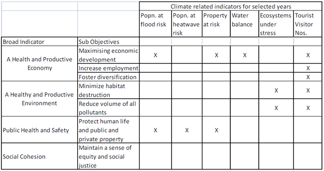
Table 1: Possible climate related Indicators that complement other indicators for the ICZM
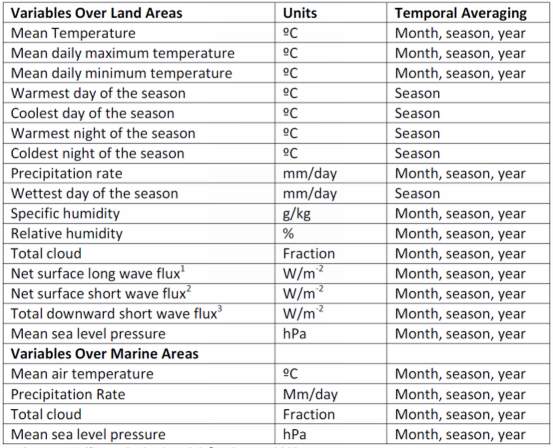
Note: Each indicator will need further clarification refinement before it can be estimated.These and other broad estimates of climate impacts in the region are a strong indication of the magnitude of the impacts that need to be taken into account in any future ICZM plans. In doing, however, it is important to avoid duplication of effort and to draw on existing work that has been undertaken at the national, regional and global levels. The best point of departure is the National Communication by the country the UNFCC, which should provide at least national level estimates of the main impacts in terms of temperature increase, sea level rise, precipitation and extreme events. By the very nature of the problem [3], such data cannot consist of point estimates, but must be provided in the form of ranges. Thus they will take a form that makes it appropriate to adopt a risk based assessment at future stages of the process. Box 1 provides a description of the kind of data available for a mature economy such as the United Kingdom. Tables 2 and 3 describe the data that is typically provided. Other countries may not have quite the same level of geographical detail; if the impacts are likely to be significant it may be worth asking a specialised agency such as the UK Met Office or the Danish Climate centre to customise projections for specific coastal regions. This is likely to involve some outlays, which may be recoverable from international institutions supporting the preparation of the programme.
Box1: Impacts data Available for Coastal Zones in the UK
Data are available for a range of future socio-economic scenarios and allowing for different probabilities of climatic outcomes. For example, in the UK the following kinds of data are available for 25x25km grids on a probabilistic basis. The 20 variables for which date are given are listed in Table 1. Projections are averaged for each of seven future overlapping 30 year time periods: 2010-2039; 2020-2049; 2030-2059; 2040-2069: 2050-2079; 2060-2089; 2070-2099. All changes are expressed relative to a modeled 30-yr baseline period of 1961-1990.
Some information is also available in probabilistic terms, which provides a central estimate (e.g. 50% probability of not being more than a given increase in temperature), and very unlikely events (e.g. a 10% probability of being less than a given increase in mean temperature value or more than a given increase in mean temperature). These are based on 3 emissions scenarios plus other uncertain parameters. For marine areas the information available includes, as noted in Table 1, the sea level rise (with the probabilistic information as indicated above for mean temperature rise). In addition the marine projections include information on projected storm surges. The last gives the projected elevation of the projected high tide under different return levels (e.g. 50 year return levels). Figures are available with different confidence intervals. A third piece of climate information that is projected is changes in offshore waves. This gives changes in winter mean wave height but uncertainties in this variable cannot be expressed in probabilistic terms.
Impacts of Climate Variability and Change
The data on climate variability and change is used to assess the impacts in the key sectors of interest and to assess the risks involved. In coastal zones the key sectors are likely to be the following:
- Impacts on agriculture
- Coastal infrastructure (housing, public buildings, roads etc.)
- Impacts of extreme events (heat waves, floods etc.)
- Sea level rise
- Availability of freshwater
- Impacts on tourism
- Loss of ecosystem services through low river flows, flooding etc.
- Supply and demand for energy
Table 2: Data Provided on a Downscaled Basis for Making a Risk Assessment
Source: UK Climate Projections Briefing Report, 2009.
Note:
- Net surface long wave flux is a measure of the total amount of long wave radiation that flows through a unit area per unit time at the Earth’s surface.
- Net surface short wave flux is a measure of the total amount of shortwave radiation that flows through a unit area per unit time at the Earth’s surface.
- Total downward surface shortwave flux is a measure of the amount of shortwave radiation received by a unit area per unit time at the Earth’s surface.
Table 3: Typical Data Reported from the Climate Models
Projections for SW England in the 2050s
Note: Comparisons are relative to the 1960-1990 climate average
Source: UK Climate Projections Briefing Report, 2009.
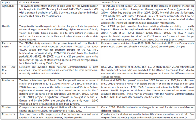
The main sources of data linking climate variability and change to impacts by sector and the main assessed impacts for the Mediterranean region are summarised in Table 4.
Table 4: Main Impacts of Climate Variability and Change and Sources of Data
The main lessons to be learnt from this are the following:
- Many of the predictions are for a wider area than just a coastal zone, and certainly wider than the part of a coastal zone likely to be of interest to the drawing up of an ICZM strategy. Thus more downscaled estimates may well be needed, which will necessitate (a) downscaled climate projections and (b) response functions that link impacts to climate variability and change;
- The projections that are available have a high level of uncertainty. This is not fully reflected in the Table but the studies either give ranges of estimates or put in a lot of qualifications indicating why we have to be aware of the level of uncertainty. This makes taking a risk assessment approach important; the timing of the impacts is important. Several are long term (over 60 years) and therefore less relevant to the current plans for many but not all activities. Areas where such impacts are a matter of concern include investments in infrastructure, roads, land use planning and some energy supply systems. On the other hand long term agricultural and health projections are not so important for current plans. Cases where shorter term impacts are important include water, flood protection, tourism and agriculture.
- The table refers to impacts at the sector level but what matters for policy purposes is often the number of people affected, or the damage to property, crops or other economic activities. This will require some further work on the part of the team drawing up the ICZM, but even in this case local studies on the ‘downstream’ consequences of the impacts may be available. A thorough literature research is recommended.
Risk Assessment
The data collected on the impacts should be presented in a form that can be fed into the drawing up of the policies and priorities in the ICZM. Given the high level of uncertainty the recommended approach is to provide a ‘central’ estimate of impacts, qualified with a ‘low risk’ figure and a ‘high risk’ figure. These estimates can take two forms: a monetary value of the damages or benefits and physical estimates. The former will require some further work, in which some of the physical losses shown in Table 4 can be converted into money values.
Again there is research on this; see for example, Ciscar, 2010 and more widely the results of the PESETA project and the more recent Climate Costs project [4]. The estimates can be presented as shown in Table 5.
Table 5: Risk and Damage Representation
| Risk | Low Risk | Central Estimate | High Risk |
| Damages Monetary | € | €€ | €€€ |
| Damages Not Included in Monetary Total | P | PP | PPP |
Monetary damage estimates can be made for coastal and other infrastructure, health, some ecosystem services, changes in availability of freshwater, changes in tourism and changes in agriculture. Both monetary and physical impacts data will be relevant to the next stage of the ICZM.
Identifying futures
Policies and priorities for action will be taken based on all three pillars of sustainable development: economic, environmental and social. The climate change factors to be discussed are of varying importance, depending on which sector or area of policy is under consideration. In this section we present those policy areas where the climatic factors have an important role. The range of policies and options will be identified in the strategy, along with possible pilot actions action sources of funding. The selection of the actual policies options will be done when drawing up the national and local plans (depending on whether the policies and options are local or national). At this stage the elaboration of the pilot actions and sources of funding will be elaborated.
Agriculture
The impacts on agriculture are likely to be of wider interest and relevance than just to the coastal community. Adaptation measures undertaken will include research and development on crop varieties better suited to the new climate, improved irrigation where appropriate and extension and other support to farmers to assist them to adapt to climatic changes. In coastal zones where water is already at a premium appropriate adaptation plants may different from other areas and it is probably best that those responsible for the ICZM participate actively in National agricultural adaptation programmes as well as in the planning for water allocation and management.
Infrastructure
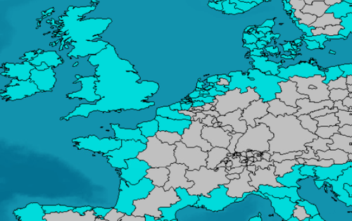
Sea level rise and changes in extreme events have a direct bearing on coastal infrastructure. Fortunately this is an area that is most developed in terms of tools for the assessment of appropriate responses. In particular the DIVA model has been used to estimate the required investment in coastal protection for different parts of the European coastline [5]. The model looks at the direct impacts on erosion, (ii) increased flood risk and inundation, (iii) coastal wetland loss and change, and (iv) salinisation. It estimates the best responses on the basis of their costs and benefits. The responses considered include flood defences and beach nourishment but not all the softer options such as insurance. The model has been applied to most of the European coastline, including the Mediterranean, but not to the Mediterranean countries of North Africa, the Middle East and parts of the Balkans. Figure 1 gives the coasts that have been assessed.
Figure 1: Coasts Covered under the DIVA Model
Probably the most effective action would be to run the DIVA model for the other regions of the Mediterranean. This could be done singly by country or as part of an internationally supported study for all countries. In the absence of that, a single country could undertake an assessment itself, based on the same data that is used in DIVA, namely: projections of SLR based on different scenarios, ranges of impacts derived from the scenarios and costs of different interventions for different stretches of the coastline.
A factor not considered by the DIVA model is changes land use planning, as it assumes current practices will be maintained in the future. Yet an important tool of adaptation is precisely to limit land use in areas likely to be inundated. This aspect can be built into the adaptation strategy by providing the DIVA model with data on populations in different locations in the future. Funding for the application of DIVA may be available from global funds.
Health
As with agriculture, this is a wider issue than just for coastal zones, although the latter could be specially impacted if there is an increase in vector borne diseases. Impacts of climate on health through contaminated food and water will require stricter controls on vendors of products to the public. The ICZM needs to review its regulations and look at ways of improving health safety where required.
Water
Adaptation to changes in water supply will take the form of reductions in demand (measures that promote more efficient use, increases in water charges) as well as increases in storage and available supply. The latter could involve building of reservoirs, increasing capacity to manage runoff, plans for water allocation in periods of drought and even the transfer of water from surplus to deficit areas. There is also the option of building desalinisation facilities to meet water deficits. In coastal areas all of these could be relevant and need to be considered in the context of the ICZM, including the demands for water created by any plans to increase activities such as tourism.
Extreme Events
Increased risks of flooding and damages from heavy rains, winds etc., should have been identified in the stage 2.1 Building the evidence. Appropriate actions will include land use changes, improved flood and hurricane protection, as well as better insurance to provide coverage against damages. Many of these actions will also be considered at the national level, so plans should be drawn up in collaboration with the national authorities. Current thinking on this issue for coastal zones in developing countries is summarized in the Box 2 below [6]. It is worth nothing that as a response to the Cairo overarching principle, the coastal setback zones stipulated under Article 8-2 of the Mediterranean ICZM Protocol is part of the “broader goal of preventing natural risks and adapting to climate change, and is a major tool to achieve this goal”.
Box: Extreme Events and Climate Change in Coastal Zones
In the aftermath of the 2004 tsunami in the Indian Ocean, UNEP/GPA (Global Programme of Action for the Protection of the Marine Environment from Land-based Activities) convened a meeting in February 2005 in Cairo (Egypt) to discuss post-tsunami reconstruction and coastal zone rehabilitation and management in affected countries. The meeting adopted 12 guiding principles which were initially drafted by integrated coastal management practitioners and, to a large extent, encapsulate the approaches that seek to reduce coastal areas vulnerability to both man-made and natural hazards. In the end, these principles were endorsed by senior government officials from tsunami affected countries, representatives from UNEP Regional Seas Programmes, and other UN agencies including FAO and IOC-UNESCO, as well as by international institutions such as IUCN, the World Bank and the WWF.
The 12 principles are:
- Overarching principle: Reduce the vulnerability of coastal communities to natural hazards by establishing a regional early warning system, applying construction setbacks, greenbelts and other no-build areas in each nation, founded on a scientifically mapped “reference line”.
- Promote early resettlement with provision for safe housing; debris clearance; potable water; sanitation and drainage services; and access to sustainable livelihood options.
- Enhance the ability of the natural system to act as a “bioshield” to protect people and their livelihoods by conserving, managing and restoring wetlands, mangroves, spawning areas, seagrass beds and coral reefs; and by seeking alternative sustainable sources of building materials, with the aim of keeping coastal sand, coral, mangroves and rock in place.
- Promote design that is cost-effective, appropriate and consistent with best practice and placement of infrastructure away from hazard and resource areas, favouring innovative and soft engineering solutions to coastal erosion control.
- Respect traditional public access and uses of the shoreline, and protect religious and cultural sites.
- Adopt ecosystem-based management measures; promote sustainable fisheries management in over-fished areas, and encourage low-impact aquaculture.
- Promote sustainable tourism that respects setback lines and carrying capacity, benefits local communities and applies adequate management practices.
- Secure commitments from governments and international organizations to abide to these Principles and build on and strengthen existing institutional arrangements where possible.
- Ensure public participation through capacity building and the effective utilization of all means of communication to achieve outcomes that meet the needs and realities of each situation.
- Make full use of tools such as strategic environmental assessment, spatial planning and environmental impact assessment, to identify tradeoffs and options for a sustainable future.
- Develop mechanisms and tools to monitor and periodically communicate the outcomes of the reconstruction through indicators that reflect socio-economic change and ecosystem health.
- Widely disseminate good practices and lessons learnt as they emerge
Tourism
For most coastal zones tourism is a key sector and the impacts of climate change on visitor numbers is critical information in the planning and management of the areas. Studies have now been conducted on this topic; for a useful survey of the literature see Fischer, 2007. The studies provide estimates of changes in numbers under different scenarios. For the Mediterranean the summary appears to be that the region will be too hot during summer, but the climatic conditions will improve during spring and autumn. Considering the improving summer temperatures in northern Europe, it is likely that the Mediterranean and its related tourism industry will encounter a decrease (dramatic decrease in Spain) in international tourist arrivals in summer and an increase during the shoulder periods (spring and autumn), especially in Spain, Greece and Turkey, and the winter season will become more attractive in North Africa. More detailed figures are available in the references cited in this survey article.
In terms of planning the data will determine the nature of the facilities offered as well as the volumes of visitors that can be expected. It will be a direct input into strategies for the kind of developments that are appropriate for each coastal zone.
Ecosystems
As noted, the impacts on ecosystems are very location specific. Studies under the CIRCE project identify low flows in rivers as an important impact, but there are also expected consequences on marine systems and fisheries. This is an area where those responsible for the ICZM should undertake a local assessment, drawing of course on the existing literature. Information collected at the analysis stage will influence the measures that need to be introduced. Some downscaling of impact assessment using models will probably be required ad funding for this may be available from global funds [7]. For rivers, low flow alleviation may be required to avoid loss of recreation services as well as risks of species. For marine areas, protection of new areas may be advisable and some measures may be needed to protect fisheries.
See Also
Please note that others may also have edited the contents of this article.
|
References
- ↑ Hallegatte S, Somot S & Nassopoulos H. (2007). Région méditerranéenne et changement climatique: une nécessaire anticipation. Expert report IPEMed.
- ↑ Van Grunderbeeck P & Tourre YM. (2008). Bassin méditerranéen: changement climatique et impacts au cours du XXIème siècle. In: Thibault HL & Quéfélec S. (eds.) Changement climatique et énergie en Méditerranée, 1:1, 1.3-1.69.
- ↑ One important reason is that future emissions and concentrations of greenhouse gases are not known and depend on what policies are adopted to control them. But other sources of uncertainty also exist.
- ↑ For Climate costs see: http://www.climatecost.cc/reportsandpublications.html. For the PESETA project see http://peseta.jrc.ec.europa.eu/results.html. In some cases it may be possible to give probabilities for the different outcomes. Where it can be provided it should, but this is not usually possible.
- ↑ Richards, J. and R. Nicholls (2011) “Impacts of climate change in coastal systems in Europe. PESETA-Coastal Systems study. European Commission, Joint Research Centre, Institute for Prospective Technological Studies, Seville
- ↑ Henocque, Y. (2011). “Analysis and Lessons Learned from National Coastal Management Strategies around the World”, PAP/RAC Split.
- ↑ For the choice of downscaling methods for this and other impacts see Sunyer, M. A., Madsen, H., Ang, P. H. (2011), A Comparison of Different Regional Climate Models and Statistical Downscaling Methods for Extreme Rainfall Estimation Under Climate Change, Atm. Res., In Press.
