Difference between revisions of "Sand spit"
Dronkers J (talk | contribs) (Created page with " {{Definition|title= Sand spit |definition= Accretionary feature formed by littoral drift, consisting of a long narrow accumulation of sand or gravel, lying generally in l...") |
Dronkers J (talk | contribs) |
||
| Line 5: | Line 5: | ||
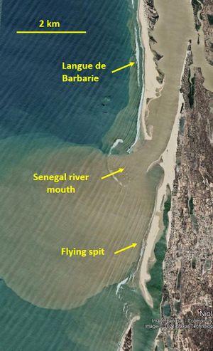
| − | [[File:SandSpitsSenegalRiverNov2020.jpg|thumb|300px|left|Sand spits at the mouth of the Senegal river | + | [[File:SandSpitsSenegalRiverNov2020.jpg|thumb|300px|left|Sand spits at the mouth of the Senegal river. The turbid Senegal river plume is clearly visible. The spit at the upper part of the image is the tip of the "Langue de Barbarie". The orientation of the wave crests indicates oblique wave incidence from the north, implying north-to-south littoral drift. Other notable features are: an ebb shield at the river mouth; an ebb [[Deltas|delta]] at the southern inlet ; so-called "flying spits" around the river mouth; cuspate [[rhythmic shoreline features]] on the landward side of the spit. Google Earth image.]] |
==Notes== | ==Notes== | ||
| − | Sand spits are ubiquitous on sandy coasts with strong littoral drift; they usually develop where the coastline bends inland from the longshore drift direction. The tip of the spit is | + | Sand spits are ubiquitous on sandy coasts with strong littoral drift; they usually develop where the coastline bends inland from the longshore drift direction. The spit follows the longshore direction of the updrift coast. The tip of the spit is typically curved in onshore direction, due to phenomena such as: |
| + | *overwash: sand washed over the spit by overtopping waves and deposited at the leeside; | ||
| + | * incidental changes in the wave incidence direction; | ||
| + | * flood currents around the tip of the spit. | ||
| + | Sand spits can block the river outflow, causing the river mouth to migrate in downdrift direction. A famous example is the "Langue de Barbarie", a sand spit that forces the mouth of the Senegal river several tens of kilometers to the south (see the figure). The spit is breached incidentally in situations of exceptional river discharge. After every breach, the spit resumes its southward growth of several hundred meters per year. | ||
Revision as of 22:09, 2 April 2021
Definition of Sand spit:
Accretionary feature formed by littoral drift, consisting of a long narrow accumulation of sand or gravel, lying generally in line with the coast, with one end attached to the land and the other projecting into the sea or across the mouth of an estuary or lagoon.
This is the common definition for Sand spit, other definitions can be discussed in the article
|

Notes
Sand spits are ubiquitous on sandy coasts with strong littoral drift; they usually develop where the coastline bends inland from the longshore drift direction. The spit follows the longshore direction of the updrift coast. The tip of the spit is typically curved in onshore direction, due to phenomena such as:
- overwash: sand washed over the spit by overtopping waves and deposited at the leeside;
- incidental changes in the wave incidence direction;
- flood currents around the tip of the spit.
Sand spits can block the river outflow, causing the river mouth to migrate in downdrift direction. A famous example is the "Langue de Barbarie", a sand spit that forces the mouth of the Senegal river several tens of kilometers to the south (see the figure). The spit is breached incidentally in situations of exceptional river discharge. After every breach, the spit resumes its southward growth of several hundred meters per year.
Many back barrier lagoons with highly variable river inflow experience seasonal closure of the sea outlet by growth of the spit in periods of drought. The spit is breached at high river discharge, but the coastal zone around the lagoon may be flooded before the outlet is fully restored.