Difference between revisions of "Remote sensing"
Dronkers J (talk | contribs) |
Dronkers J (talk | contribs) |
||
| Line 135: | Line 135: | ||
:[[Monitoring coastal morphodynamics using high-precision multibeam technology]] | :[[Monitoring coastal morphodynamics using high-precision multibeam technology]] | ||
:[[Optical Laser diffraction instruments (LISST)]] | :[[Optical Laser diffraction instruments (LISST)]] | ||
| + | :[[Remote sensing of zooplankton]] | ||
:[[Optical backscatter point sensor (OBS)]] | :[[Optical backscatter point sensor (OBS)]] | ||
:[[Instruments and sensors to measure environmental parameters]] | :[[Instruments and sensors to measure environmental parameters]] | ||
Revision as of 16:51, 18 February 2024
Contents
Introduction
There is an increasing demand for accurate, timely information on natural resources and ecosystems, their spatial distribution and temporal changes and trends, from local to global. In the broadest sense, remote sensing is the measurement or acquisition of information about an object or phenomenon by a sensor that is not in direct physical contact with the object. Information is conveyed by waves radiating from the object. The sensor is mounted on a fixed frame (a mast) or on a moving platform, for example an aircraft, drone, satellite or a frame towed behind a ship.
Advantages of this technology are:
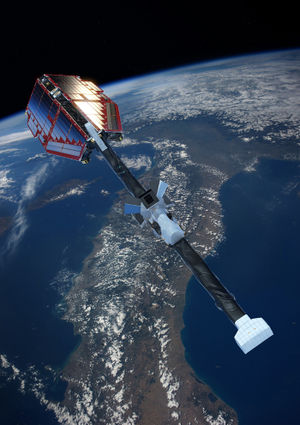
- Observation of a large geographical area (from aircraft or satellite - Fig. 1)
- Long-term and fast collection of data (from satellite)
- Low collecting costs
- "Inaccessible" regions become accessible (e.g. Antarctica)
- Object is not being perturbed or destroyed
Disadvantages are:
- Lower spatial resolution than in situ measurement (depending on the type of platform or sensor)
- Initial investment in development and installation
- Collected data need to be calibrated via in-situ data
- Noise caused by another source than the desired one
- Atmospheric effects degrade the quality of the images and need to be corrected
Brief history
| 1826 | Invention of photography by Joseph Nicéphore Niépce |
| 1850s | Photography with cameras from hot-air balloons |
| 1903 | Invention of pigeon photography (used during World War I and the Civil War) |
| 1904 | Invention 'telemobiloscope', first radar-type device by Christian Hülsmeyer |
| 1909 | Photography from air planes |
| 1913 | First acoustic underwater transducer patented by Reginald A. Fessenden, precursor of the sonar (sound navigation and ranging). |
| World War I | Military surveillance: airplanes with cameras |
| 1920 | First detailed seafloor maps using sonar by the US Coast and Geodetic Survey. |
| 1922 | Borehole radar using pulsed modulation patented by Loewy |
| 1930 | Invention of Lidar (acronym of "light detection and ranging" or "laser imaging, detection, and ranging") by E. H. Synge |
| 1942 | First ship radars for the fleets of the U.S. and British navy |
| 1960s | Space programs and race between the United States (US) and the Soviet-Union (USSR) |
| 04 October 1957 | Sputnik I (USSR): first artificial satellite to go into orbit |
| 31 January 1958 | Explorer I (US) is launched |
| 1960 | TIROS-1: first meteorological satellite. First use of term 'Remote sensing' |
| 1961 | First Lidar system developed by the Hughes Aircraft Company |
| 1964 | First application of marine X-band (or microwave) radar for ocean wave imaging by Ijima et al. (1964[1]) |
| 1972 | Landsat-1: launch of the first earth resource satellite |
| 1990s | Launch of earth resource satellites by national space agencies and commercial companies |
General principles of remote sensing
Remote sensors are devices that measure and record specific types of energy. This energy is electromagnetic radiation in remote sensing via the air; underwater remote sensing usually involves acoustic waves. The electromagnetic spectrum is the distribution of radiation energy over wavelengths. The spectrum can be divided into different spectral ranges: gamma rays, X-rays, ultraviolet, visible light, infrared, microwaves and radio waves (Fig. 2). Remote sensing involves measuring energy in spectral bands - discrete intervals of the EM spectrum. Satellite sensors are designed to measure signals emitted by objects on the Earth's surface within certain spectral bands from which the characteristics of these objects can be inferred. Scientists choose a particular spectral band for data collection depending on what they want to investigate. The data recorded by the sensors must be pre-processed (corrected, enhanced), analyzed (classified) and interpreted to provide useful information. Simple traditional methods of visual interpretation have evolved into advanced mathematical and statistical methods using models and analysis techniques as described in Data analysis techniques for the coastal zone and many other articles in the Coastal Wiki.
Types of sensors
Remote sensing systems can be divided into 2 categories: active and passive sensors. Active sensors (usually detection and ranging systems such as radar, sonar, Lidar) emit radiation which is directed toward the object or surface to be investigated. The radiation emitted by an active sensor provides a specific spectral energy pulse to the study object that activates a response signal which is detected, measured and timed by the sensor. It thus allows to determine distances (ranges). Passive systems (e.g. photographic camera) record the radiation emitted by an object that receives radiation (energy) from an external energy source (for example the sunlight). The radiation emitted by an object is due to reflection, backscatter (diffuse) and re-emitted back radiation. It can provide information about the shape (via reflected radiation), pattern, type of substance and composition of the object.

Atmospheric effects
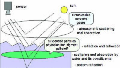
Remote sensors that observe the Earth are looking through the atmosphere. The atmospheric constituents (particles and gases) can affect the incoming light and radiation by causing wavelength-dependent absorption and scattering (Fig. 3). Scattering occurs when particles or large gas molecules present in the atmosphere interact with the electromagnetic radiation and cause it to be diverted from its original path. Absorption causes molecules in the atmosphere to absorb and re-emit energy at various wavelengths. Ozone, carbon dioxide and water vapor are the most important atmospheric constituents that absorb radiation.
These atmospheric effects degrade the quality of the images. They need to be corrected for before the images are subjected to further analysis and interpretation.
Sunglint, the direct reflection of the sun from the water surface to the sensor, is another effect that must be corrected for.
Remote sensing applications in the Coastal Wiki
- Plankton, algae: Plankton remote sensing, Plankton remote sensing North Sea, Remote sensing of zooplankton, The Baltic Algae Watch System - a remote sensing application for monitoring cyanobacterial blooms in the Baltic Sea
- Habitats: Use of Lidar for coastal habitat mapping, Tidal flats from space, The HIMOM and OFEW approaches to monitoring intertidal flats, Acoustic kelp bed mapping in shallow rocky coasts - case study Helgoland (North Sea), Application and use of underwater video
- Animals: Acoustic monitoring of marine mammals
- Suspended sediment: Optical Laser diffraction instruments (LISST), Optical backscatter point sensor (OBS), Acoustic backscatter profiling sensors (ABS)
- Pollution: Oil spill monitoring
- Bathymetry: Satellite-derived nearshore bathymetry, Bathymetry from remote sensing wave propagation, HyMap: Hyperspectral seafloor mapping and direct bathymetry calculation in littoral zones, Bathymetry German Bight from X-band radar, Monitoring coastal morphodynamics using high-precision multibeam technology, Instruments for bed level detection, Argus applications
- Shoreline: Use of aerial photographs for shoreline position and mapping applications
- Waves: Waves and currents by X-band radar, Measuring instruments for fluid velocity, pressure and wave height
- Currents: Measuring current fields in the German Bight by radar techniques, Application of radar hydrography in the German Wadden Sea, Acoustic point sensors (ASTM, UHCM, ADV), Currents and turbulence by acoustic methods
- Wind: WiRAR - A marine radar wind sensor, WiSAR - Wind retrieval from synthetic aperture radar
Satellite remote sensing
- Light fields and optics in coastal waters
- Optical remote sensing
- Plankton remote sensing
- Plankton remote sensing North Sea
- Satellite-derived nearshore bathymetry
- Oil spill monitoring
- Use of Lidar for coastal habitat mapping
- HyMap: Hyperspectral seafloor mapping and direct bathymetry calculation in littoral zones
- Plankton remote sensing
- Remote sensing of zooplankton
- The Baltic Algae Watch System - a remote sensing application for monitoring cyanobacterial blooms in the Baltic Sea
- Bathymetry from remote sensing wave propagation
- Use of aerial photographs for shoreline position and mapping applications
- SeaWiFS
- MODIS
- MERIS
- Tidal flats from space
- Space geodetic techniques for coastal zone monitoring
- Detecting the unknown - novelty detection of exceptional water reflectance spectra
- The HIMOM and OFEW approaches to monitoring intertidal flats
Radar remote sensing
- Waves and currents by X-band radar
- Bathymetry German Bight from X-band radar
- Measuring current fields in the German Bight by radar techniques
- Application of radar hydrography in the German Wadden Sea
- WiRAR - A marine radar wind sensor
- WiSAR - Wind retrieval from synthetic aperture radar
Under water remote sensing
- General principles of optical and acoustical instruments
- Monitoring coastal morphodynamics using high-precision multibeam technology
- Optical Laser diffraction instruments (LISST)
- Remote sensing of zooplankton
- Optical backscatter point sensor (OBS)
- Instruments and sensors to measure environmental parameters
- Acoustic monitoring of marine mammals
- Acoustic point sensors (ASTM, UHCM, ADV)
- Acoustic backscatter profiling sensors (ABS)
- Currents and turbulence by acoustic methods
- Acoustic kelp bed mapping in shallow rocky coasts - case study Helgoland (North Sea)
- Instruments for bed level detection
- Measuring instruments for fluid velocity, pressure and wave height
Video camera
- Argus video monitoring system
- Argus video
- Underwater video systems
- Video technology
- Application and use of underwater video
- Argus applications
Please note that others may also have edited the contents of this article.
|
- ↑ Ijima, T., Takahashi, T. and Sasaki, H. 1964. Application of radars to wave observations. Proc. 11th Int. Conf. Coastal Engineering 30: 10-22

