Using satellite data for global wave forecasts
Contents
Introduction
Ocean surface waves are the greatest environmental danger for all offshore operations. In particular the ships and offshore platforms are exposed to the severe wave forces (Fig.1). Therefore accurate prediction of the sea-state for the next 7 to 10 days, which is the typical travel period for ships to cross the oceans, is absolutely necessary to minimise the risk at sea. The Deutscher Wetter Dienst (DWD) responsible for this forecast service in Germany therefore has combined its wave prediction system with an assimilation system using wave data measured by satellites. The system was set up and introduced into the operational DWD model by the GKSS Research Centre.
The wave model
The wave forecasting system is based on the third generation WAM Model (WAMDI, 1988[1]; Komen et al., 1994[2]). This community model was developed by the international WAM group and is maintained and distributed worldwide by GKSS. Wind fields predicted by the atmosphere model of the DWD force the wave model. It accounts for wave propagation on a spherical grid and modifies the waves due to refraction and shoaling. Wave dissipation is done by white capping and bottom friction. The non-linear wave-wave interaction is implemented by the DIA approximation. Sea ice fields provided by the Bundesamt für Seeschifffahrt und Hydrographie (BSH) are used in the operational set-up to dissipate the wave energy in the ice covered areas.
| ||||||||
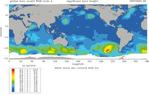
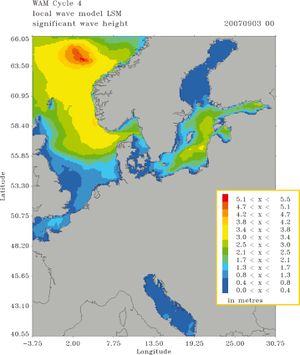
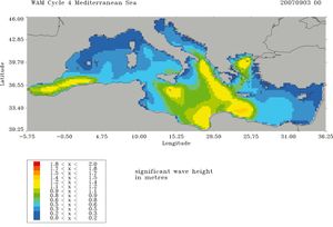
The present model system consists of a global model (GSM) with a spatial resolution of 0.75° x 0.75° which provides boundary values for the local model (LSM) for the North Sea and Baltic Sea with a resolution of 0.1° x 0.167° and a model for the Mediterranean Sea (MSL) with a 0.25° x 0.25° resolution. Fig. 2 shows the three model areas with the results of the predicted significant wave height for September 3rd 2007 at 0 UTC. The forecast range is 7 days for the global and 3 days for the local area models. In addition the global model provides boundary forcing for a local area model of the Omani and Abu Dhabi meteorological services, which run operational wave models for the Persian Gulf and the Arabian Sea.

The wave data
Wave measurements provided in near real time through the Global Telecommunication System (GTS) of the World Meteorological Organisation (WMO) are used for verification and data assimilation. Data from the radar altimeters on board the ERS-2, ENVISAT, and JASON satellites are assimilated into the model by first guess fields 8 times per day to improve the analysis of the global sea state and the initial fields for the forecasts. Measurements from about 138 wave buoys are gathered but not assimilated. They are used as an independent data set for an automatic validation of the model forecast and analysis performance. Monthly statistics are evaluated.
The assimilation method
To assimilate the satellite data, a sequential optimum interpolation scheme is applied (Lionello et al., 1992[3]). Significant wave heights and wind speeds measured about every 5 km along the satellite paths are merged with the model first guess fields. In a second step these analysed fields are used to update the wave spectra, which are the prognostic variables of the model. An integral part of the assimilation system is an advanced quality control (QC) scheme for the altimeter data. This is based on statistical methods for checking absolute values and variances of the data along the satellite track and within individual model grid boxes.
Summary
In order to improve the start fields for the global wave forecasts in the numerical routine of the DWD, a 12-hour hindcast has been added that runs prior to the usual 7-day forecast. All satellite radar altimeter data that are available for this time period will be assimilated into the fields of the GSM. Fig. 3 shows pictures of the 3 satellites that continuously provide significant wave heights and wind speeds as a fast delivery product. A second advantage is the possibility to use the analysed wind fields of the global atmospherical model during the 12-hour hindcast period as the driving force for the wave model. Therefore it can be expected that the improved start fields for the usual 7-day forecast will also induce improved forecast results, especially during the first simulation day. The first example given below addresses a comparison of the results obtained by the wave forecast system including data assimilation and those computed without data assimilation. In both cases exactly the same wind fields have been used to drive the GSM. A second example discusses a regional application of the DWD wave forecast system and, although the regional model LSM does not include the data assimilation itself, it definitely takes advantage of the improved boundary values that are provided by the GSM.
Global impact of the assimilation
The impact of the data assimilation on the fields of the global model GSM has been determined by comparing the results of two runs for the time period September 1st to September 30th 2007. The only difference in these runs was the data assimilation in one of the two. Fig. 4 shows the distribution of the difference of the significant wave heights obtained with data assimilation and without for September 3rd 2007 at 0 UTC. It is obvious that the general trend of the assimilation effect is an enhancement of the wave heights, especially in the southern hemisphere. Maximum differences occur on that day south- west of Australia (up to 4 m), south of Africa and east of Japan. A statistical analysis of the results of both runs in comparison with measurements at the 138 buoy locations shows an improvement due to the assimilation in 60.2 % of all cases for September 2007. The impact of the assimilation on the statistics is shown at three selected buoy locations in Table 1, two in the Atlantic and one in the Pacific. These comparisons are representative for all of the 138 buoys. The trend of the increased wave heights is confirmed by the bias (measurements - model results). The negative bias decreases for the two Atlantic locations and therefor all the statistical checks. .
A severe storm in the Baltic Sea
A spectacular application of the regional model for North Sea and Baltic is the investigation of the severe storm Gudrun, an extra-tropical cyclone that crossed over northern Europe in January 2005 and left behind extreme destruction in Scandinavia and the Baltic countries. Besides a storm surge at the coasts of the Baltic countries, the operational numerical regional wave forecast of the DWD predicted unusually high waves for the Baltic Proper and the Gulf of Finland. Fig. 5 shows the distribution of the significant wave height and the corresponding wind speed and direction in the LSM model area during the storm peak. The maximum wave height of about 11 m near the coast of Lithuania is emanated from a forecast released on January 8th 2005 at 12 UTC. A hindcast for the same time period, driven by the analysed wind fields of the local atmospherical model of the DWD provided a maximum wave height of about 10 m, which seems to be more realistic. Measurements were available during that period at 3 locations, one in the open Baltic Proper and two in the Gulf of Finland. Fig. 6 includes a time series plot for the measured and computed significant wave heights at the buoy location FIMRB (59°15' N, 21°00' E) in the Baltic Proper. Besides the results of the DWD model, the measurements have also been compared with the results of the forecast models of the Danish Meteorological Institute (DMI) and the Finnish Institute of Marine Research (FIMR). The maximum measured significant wave height is about 7 m at the storm peak at 3 UTC on January 9th 2005 and is well predicted by the forecast models. This example shows how important high quality wave forecasts are. To know about such dangerous wave conditions already two days in advance can save lives and prevent economical damages.
References
- ↑ WAMDI group (1988). The WAM model - a third generation ocean wave prediction model. Journal of Physical Oceanography, 21, 149-172.
- ↑ Komen, G.J., Cavaleri, L., Donelan, M., Hasselmann, K., Hasselmann, S. & Janssen, P.A.E.M. (1996). Dynamics and modelling of ocean waves. Cambridge, UK: Cambridge University Press.
- ↑ Lionello, P., Günther, H. & Janssen, P.A.E.M. (1992). Assimilation of Altimeter Data in a Global Third-Generation Wave Model. Journal of Geophysical Research, 97 (C9), 14453-14474.
Please note that others may also have edited the contents of this article.
|
Please note that others may also have edited the contents of this article.
|


