Bouches du Rhone
CASE description
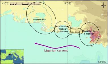
The Coast of the Bouches du Rhône (120 km) is characterised by calanques (rocky shore), urban, industrial zone, delta, sandy beaches. In the dyked area of the Camargue, the sea has gained the upper hand, in part because modification in the hydrological regime and because incursions by the sea are increasing (due to subsidence and the rising level of the Mediterranean).
ICZM phase
Main coastal issues
Conflicting uses among:
- Coastal and marine natural zones are becoming increasingly fragile;
- Population growth impacts the suburbs around Marseille;
- The development of farming was contrasted;
- Urban growth issues: urban density is growing;
- Traffic and access issues.
Relation between the coastal issues and the ICZM protocol principles and articles
The CASES Bouches du Rhône will concentrate on three articles of the protocol to respond to the coastal issues identified in the territorial diagnostic.
Article 7: Coordination Provide an opportunity for coordination through appropriate bodies in order to avoid sectoral approaches and facilitate comprehensive approaches.
Article 14: Participation Contribute to efficient governance by ensuring appropriate involvement in the phases of the project and the development of tools.
Article 16: Monitoring and observation mechanisms and networks Contribute to the use and strengthening existing mechanisms for monitoring and observation (through indicator development and sharing, LEAC, and economic valuation).
Relevance of the coastal issues
The segmentation of the CASES Bouches du Rhône is qualified by the existence of management issues common to different units. It is important to identify these common issues in the backdrop of the implementation of the Marine Strategy Framework Directive (MSFD) on the Mediterranean coastal zone.
- Coastal and marine natural zones are becoming increasingly fragile: this diagnosis is one of the drivers of the future Calanques National Park project but also applies to other natural zones of the CASES: wetlands of the Camargue (exposed to impacts from irrigation and from flooding protection facilities for neighbour urban suburbs); marine flora and fauna of the Cote Bleue, sensitive to tourism and visits; the water body of the Gulf of Fos, impacted by activities on the industrial and port zone of Fos and Berre; etc. Such trends have led to the creation of several protected areas, thereby progressively reinforcing the segmentation of the CASES into specialized subsets.
- Population growth impacts the suburbs around Marseilles, in particular those of the MPM Urban Community (see above) and those of the Gulf of Fos. Population density is low in the Camargue but growing. It is very high in the communes of the Gulf of Fos and in Marseilles, high and steadily growing in the communes of the Cote Bleue.
- The development of farming was contrasted in the different units over the recent years. The activity remains steady in the Camargue, with a need for protecting natural zones and especially wetlands against farming irrigation and effluent impacts. Elsewhere in the CASES area, many farming zones are exposed to the pressure from urban expansion in the Camargue and in the outskirts of Marseilles and other suburbs.
- Urban growth issues: urban density is growing. The strategy of MPM is to increase the density of existing urban areas to limit uncontrolled urban expansion and cope with land scarcely available for construction, the lack of public transport facilities, and to get urban and inter-urban traffic more rational. This strategy is directly impacting population growth and tourist visits in neighbouring areas especially the Cote Bleue. Urban density can also increase the risk of Mediterranean rainstorm pollution of coastal water bodies.
- Traffic and access issues: access, transport facilities and traffic intensiveness issues exist in the different units of the CASES for several reasons: - Urban expansion in coastal communes has increased transport demand in a zone where public transport is of limited availability.
Objectives
To implement and test tools that can help decision makers and stakeholders to:
- share a common view of the dynamics and the possible futures of this complex territory where multiple anthropogenic pressures are exerted.
- take appropriate measures to preserve coastal ecosystem services.
- manage interactions between coastal conflicting usages.
End Products
Demonstration of selected tools/methods (economic assessment and LEAC for BdR) in the CASE
PEGASO tools developed and used
indicators - LEAC - participation
Other tools to be applied
Socio-economic valuation.
CASE Responsibles
Jean-François Cadiou - Ifremer - email: Jean.Francois.Cadiou@ifremer.fr
Lisa Ernoul - Tour du Valat - email: ernoul@tourduvalat.org
Elaboration: Stefano Soriani, Fabrizia Buono, Monica Camuffo, Marco Tonino, University Ca’ Foscari of Venice.


