File:SandwavesNorthSea.jpg
From Coastal Wiki
Revision as of 16:53, 13 October 2024 by Dronkers J (talk | contribs) (Sand waves in the southern North Sea (insert upper left corner, black dot, depth 35-40 m), imaged by multibeam sonar. An indication of the order of magnitude of the wavelength of the sand waves (ca. 100 m) is given by the shipwreck of the freighter Tim...)

Size of this preview: 800 × 575 pixels. Other resolutions: 320 × 230 pixels | 935 × 672 pixels.
Original file (935 × 672 pixels, file size: 85 KB, MIME type: image/jpeg)
Summary
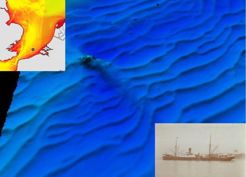
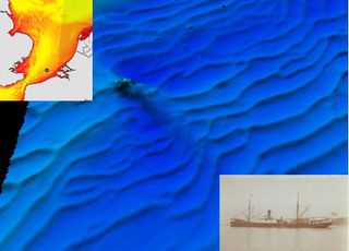
Sand waves in the southern North Sea (insert upper left corner, black dot, depth 35-40 m), imaged by multibeam sonar. An indication of the order of magnitude of the wavelength of the sand waves (ca. 100 m) is given by the shipwreck of the freighter Timor (insert lower right corner), which was torpedoed in 1917. The wave pattern is disturbed around the shipwreck; the pattern is locally less regular with smaller wavelengths. Image by Vlaamse Hydrografie.
File history
Click on a date/time to view the file as it appeared at that time.
| Date/Time | Thumbnail | Dimensions | User | Comment | |
|---|---|---|---|---|---|
| current | 16:53, 13 October 2024 | | 935 × 672 (85 KB) | Dronkers J (talk | contribs) | Sand waves in the southern North Sea (insert upper left corner, black dot, depth 35-40 m), imaged by multibeam sonar. An indication of the order of magnitude of the wavelength of the sand waves (ca. 100 m) is given by the shipwreck of the freighter Tim... |
- You cannot overwrite this file.
File usage
The following page links to this file:
