File:MeteotsunamisCiutadella.jpg
From Coastal Wiki
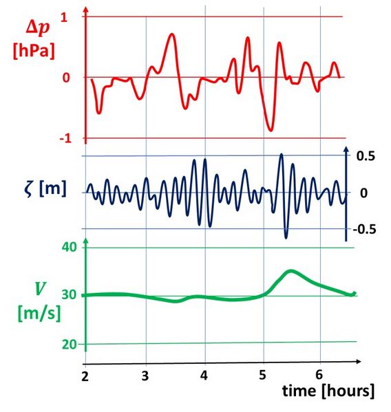
Revision as of 15:02, 16 June 2024 by Dronkers J (talk | contribs) (Meteo tsunami at Ciutadella (Menorca,Spain) on 15 September 2021. Red curve = atmospheric pressure perturbation, blue curve = harbor oscillation Ciutadella, green curve = mid-troposphese wind speed. Redrawn from Villalonga et al. (2024<ref>Villalonga,...)

Size of this preview: 568 × 599 pixels. Other resolutions: 228 × 240 pixels | 679 × 716 pixels.
Original file (679 × 716 pixels, file size: 73 KB, MIME type: image/jpeg)
Summary
Meteo tsunami at Ciutadella (Menorca,Spain) on 15 September 2021. Red curve = atmospheric pressure perturbation, blue curve = harbor oscillation Ciutadella, green curve = mid-troposphese wind speed. Redrawn from Villalonga et al. (2024[1]).- ↑ Villalonga, J., Monserrat, S., Gomis, D. and Jordà, G. 2024. Observational characterization of atmospheric disturbances generating meteotsunamis in the Balearic Islands. Journal of Geophysical Research: Oceans 129, e2024JC020910
File history
Click on a date/time to view the file as it appeared at that time.
| Date/Time | Thumbnail | Dimensions | User | Comment | |
|---|---|---|---|---|---|
| current | 15:02, 16 June 2024 |  | 679 × 716 (73 KB) | Dronkers J (talk | contribs) | Meteo tsunami at Ciutadella (Menorca,Spain) on 15 September 2021. Red curve = atmospheric pressure perturbation, blue curve = harbor oscillation Ciutadella, green curve = mid-troposphese wind speed. Redrawn from Villalonga et al. (2024<ref>Villalonga,... |
- You cannot overwrite this file.
File usage
The following page links to this file: