Plankton remote sensing
Contents
Ocean colour
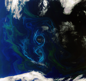
An important reason to measure ocean colour is to study phytoplankton, the microscopic algae which are at the base of the oceanic food web. Remote sensing is an invaluable tool for the detection, monitoring and prediction of algal blooms in the marine environment as these algae are considered a potential threat when they form so-called harmful algal blooms and so appropriate measures can be taken. In situ measurements are useful when more information is required on the type of algae present but when there is a sudden shift in time and location these methods become too expensive. Satellite sensors detect the reflected light by the sea surface in different wavelengths. The "colour" of the ocean is determined by the interaction of light with the water and any colored particles or dissolved chemicals in the water. Colour is the light reflected by the water and the substances present in it. When light hits a water molecule or a coloured substrate in it, the different colours (wavelengths) can be absorbed or scattered in differing intensities. The colour we see results from the colours that are reflected. The substances in seawater which most affect the water colour are: phytoplankton, total suspended matter (TSM), coloured dissolved organic matter (CDOM, also called 'gelbstoff' due to the brown-yellow reflected colour), and the water molecules themselves.
Eutrophication and algal blooms
Phytoplankton contains green-coloured chlorophyll-a (Chl-a, necessary to produce organic carbon using light and carbon dioxide during photosynthesis) which absorbs red and blue light and reflects green light. The ocean colour is therefore an indicator of the health of oceans. The chlorophyll concentrations can be inferred from satellite data by calculating the blue/green ratio of the ocean. When blue is more absorbed, green is more reflected which indicates a higher concentration of phytoplankton in the water and vice versa. It is in some cases also possible to distinguish between different phytoplankton species due to their specific algal pigment absorption, such as phycobiliproteins for cyanobacteria, fucoxanthin for diatoms and peridinin for dinoflagellates[1]. Coccolithophore blooms (in particular Emiliania huxleyi) in their senescent stage are often identifiable through ocean color remote sensing by the milky blue–green color, accompanied by the typical high scattering across all spectral bands (400–800 nm) that results from the detached coccoliths[2]. The nitrogen-fixing cyanobacterium Trichodesmium can be detected in satellite reflectance spectra due to the strong absorption by its pigment phycoerythrin in the blue green channels and reflectance in the red-near-infrared channels[3]. Harmful algae also have distinct spectral characteristics (significant absorption bands in around 500 nm, 675 nm, and reflectance peaks in 550 nm and 700 nm) that allow detection by remote sensing and make it even possible to distinguish between different species[4]. Once a bloom begins, an ocean colour sensor can make an initial identification of its chlorophyll pigment, and therefore its species and toxicity.
Remote sensing can therefore provide insight into algae dynamics and eutrophication processes. However, determining Chl-a concentrations within a range of ±35% is not always possible using the same band ratio algorithms[5]. Blue/green band ratio algorithms are suitable for open ocean waters, but their use in coastal waters is limited, due to the influence of colored dissolved organic matter (CDOM) and total suspended solids (TSM) at these wavelengths. Alternatively, many studies have shown the potential of red to NIR band ratios to detect Chl-a and algal blooms in coastal waters, as this spectral region is less affected by CDOM and TSM[6]. To better understand the mechanisms and dynamics of algal blooms, it is important to combine satellite data with datasets from other sources (in situ data, ecosystem models) and analyze them with statistical methods.[1]
Examples of colour satellites sensors are SeaWiFS (Sea-viewing Wide Field of view Sensor), MODIS (Moderate Resolution Imaging Spectroradiometer) and MERIS (Medium Resolution Imaging Spectrometer). An overview of satellites and sensors used in Earth Observation is found here.
Related articles
- Plankton remote sensing North Sea
- Light fields and optics in coastal waters
- Optical remote sensing
- The Baltic Algae Watch System - a remote sensing application for monitoring cyanobacterial blooms in the Baltic Sea
- Remote sensing of zooplankton
- Detecting the unknown - novelty detection of exceptional water reflectance spectra
References
- ↑ 1.0 1.1 Blondeau-Patissier, D., Gower, J.F.R., Dekker, A.G., Phinn, S.R. and Brando, V.E. 2014. A review of ocean color remote sensing methods and statistical techniques for the detection, mapping and analysis of phytoplankton blooms in coastal and open oceans. Progress in Oceanography 123: 123–144
- ↑ Shutler, J.D., Grant, M.G., Miller, P.I., Rushton, E. and Anderson, K. 2010. Coccolithophore bloom detection in the north east Atlantic using SeaWiFS: algorithm description, application and sensitivity analysis. Remote Sensing of Environment 114: 1008–1016
- ↑ Dupouy, C., Whiteside, A., Tan, J., Wattelez, G., Murakami, H., Andréoli, R., Lefèvre, J., Röttgers, R., Singh, A. and Frouin, R. A 2023. Review of Ocean Color Algorithms to Detect Trichodesmium Oceanic Blooms and Quantify Chlorophyll Concentration in Shallow Coral Lagoons of South Pacific Archipelagos. Remote Sens. 15, 5194
- ↑ Shen, L., Xu, H. and Guo, X. 2012. Satellite Remote Sensing of Harmful Algal Blooms (HABs) and a Potential Synthesized Framework. Sensors 12: 7778-7803
- ↑ Hu, C., Carder, K.C. and Muller-Karger, F.E. 2000. How precise are SeaWiFS ocean color estimates? Implications of digitization-noise errors. Remote Sensing of Environment 76: 239–249
- ↑ Lins, R.C., Martinez, J-M., da Motta Marques, D., Cirilo, J.A. and Fragoso Jr, C.R. 2017. Assessment of Chlorophyll-a Remote Sensing Algorithms in a Productive Tropical Estuarine-Lagoon System. Remote Sens. 9, 516
Other sources
- Canada Centre for Remote Sensing Tutorial: Fundamentals of Remote Sensing
- ESA Eduspace
- NASA earth observation
- History of Photography
Please note that others may also have edited the contents of this article.
|
