Difference between revisions of "Salt wedge estuaries"
Dronkers J (talk | contribs) |
Dronkers J (talk | contribs) |
||
| Line 81: | Line 81: | ||
|AuthorName=Dronkers J}} | |AuthorName=Dronkers J}} | ||
| + | [[Category:Physical coastal and marine processes]] | ||
[[Category:Estuaries and tidal rivers]] | [[Category:Estuaries and tidal rivers]] | ||
[[Category:Hydrodynamics]] | [[Category:Hydrodynamics]] | ||
| − | |||
Revision as of 21:54, 28 June 2019
Definition of Salt wedge:
Seawater intrusion in an estuary as a wedge-shaped bottom layer which hardly mixes with the overlying fresh water layer. Salt wedges occur in estuaries where tidal motion is very weak or absent.
This is the common definition for Salt wedge, other definitions can be discussed in the article
|
Contents
Introduction
In estuaries where tidal motion is very weak or absent, seawater intrudes in the form of a wedge along the bottom, as a consequence of the higher density of seawater compared to fresh water. The intrusion length depends essentially on two parameters: river flow velocity [math]v[/math] and water depth [math]h[/math]. This article deals with the hydrodynamic balances that determine the salt wedge, illustrated by a model for a prismatic estuary (uniform depth and width). We follow the derivation first given by Schijf and Schönfeld in 1953 [1].
In most estuaries, seawater intrusion is strongly influenced by tidal motion (see Estuarine circulation). Even in microtidal estuaries this influence is often significant [2]. In some cases, especially in the Mediterranean Sea, tides are so small that their influence on seawater intrusion is minor. This article focuses on such situations; we assume that the salt wedge is not significally altered during the slight tidal motion up and down the estuary.
Hydrodynamic balance

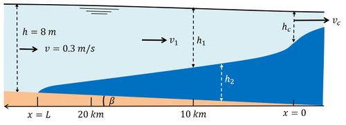
Here we introduce a simple two-layer model for describing seawater intrusion in a microtidal prismatic (uniform width and depth) estuary. The salt wedge is represented by a separate layer of thickness [math]h_2[/math] along the bottom of the estuary, see figure 1. The total water depth [math]h[/math] is the sum of the bottom layer thickness [math]h_2[/math] and the upper surface layer thickness [math]h_1[/math]. Lateral variations of depth, density (salinity) and velocity are ignored. The velocity is indicated by [math]v[/math] and the density by [math]\rho[/math]. Subscripts 1 and 2 indicate the surface layer and the bottom layer respectively.
Seawater intrusion is accelerated by the pressure gradient [math]d p_2 / d x[/math] related to the slope of the salt wedge [math]d h_2 / d x[/math] and the slope of the overlying fresh water [math]d h_1 / d x[/math],
[math]\Large \frac{d p_2}{d x} \normalsize = g \rho_2 ( \beta + \Large \frac{d h_2}{d x} \normalsize )+ g \rho_1 \Large \frac{d h_1}{d x} \normalsize , \qquad (1) [/math]
where [math]\rho_1=\rho[/math] is the fresh water density, [math]\rho_2=\rho+ \Delta \rho[/math] the seawater density and [math]\beta[/math] the bottom slope. Other symbols are shown in figure 1. Because of the lower density of fresh water compared to seawater, this pressure gradient generally acts in upstream direction. The acceleration of the salt wedge is balanced by friction at the interface induced by the overlying river flow. The shear stress [math]\tau_i[/math] exerted by river flow on the salt wedge can be parameterized as [math]\tau_i / \rho = C_i v_1^2 [/math], where [math]C_i[/math] is the interfacial shear stress coefficient of order [math]10^{-4}-10^{-3} .[/math][3]
The salt wedge intrusion is also influenced by bottom friction. However, in a stationary situation (called “arrested salt wedge”) bottom friction does not play a role because the salt wedge is at rest.
River flow is confined to a progressively thinner layer in downstream direction. The resulting acceleration of river flow creates a gradient in the hydraulic head given by [math]\rho v_1 d v_1 / d x .[/math] The surface layer is further accelerated by the surface pressure gradient
[math]\Large \frac{d p_1}{d x} \normalsize = g \rho_1 ( \beta + \Large \frac{d h_2}{d x} + \frac{d h_1}{d x} \normalsize) \qquad (2) [/math]
and decelerated by the interfacial shear stress [math]\tau_i .[/math] The hydrodynamic balance (no acceleration) of the two layers is therefore given by the equations
[math]\Large \frac{d p_2}{\rho_2 d x} + \frac{\tau_i}{\rho h_2} \normalsize = 0; \; \Large \frac{d p_1}{\rho_1 d x} \normalsize = - v_1 \; \Large \frac{d v_1}{d x} - \frac{\tau_i}{\rho h_1} \normalsize . \qquad (3)[/math]
Salt wedge model for a prismatic estuary
In a prismatic estuary the depth [math]h[/math] and width [math]b[/math] do not vary along the channel axis. By subtracting the two layer equations the salt wedge slope [math]d h_2 / d x[/math] and the bottom slope [math]\beta[/math] are eliminated. By assuming that the bottom slope is not much larger than the salt wedge slope, we may approximate [math]h_2 \approx h-h_1 .[/math] The velocity in the upper layer [math]v_1[/math] can be eliminated from the equations by using the condition of continuity of river discharge per unit width,
[math]h_1 v_1 = h v = \Large \frac{Q}{b} \normalsize, \qquad (4) [/math]
where [math]Q[/math] is the river discharge. These manipulations lead to an ordinary nonlinear differential equation for the variable [math]y=h_1 / h ,[/math]
[math] (y^3-F_i^2)(1-y) dy = \Large \frac{C_i F_i^2}{h} \normalsize dx , \qquad (5) [/math]
where [math]F_i = v [\Large \frac{\Delta \rho}{\rho} \normalsize g h]^{-1/2} = \Large \frac{Q}{hb} \normalsize [\Large \frac{\Delta \rho}{\rho} \normalsize g h]^{-1/2} [/math] is the internal river Froude number.
This equation can be easily integrated if conditions at both boundaries of the salt wedge are known.
The conditions at the tip of the salt wedge is obvious: [math]y=1[/math] at [math]x=L .[/math].
The condition at the sea boundary is more subtle. When during the process of seawater intrusion the depth of the upper layer at the sea boundary decreases, the outflow velocity [math]v_1[/math] increases. However, the intrusion process stops when the outflow velocity equals the critical velocity [math]v_c[/math] at which an upward shift of the interface cannot propagate upstream. The critical velocity for upstream propagation of a perturbation at the interface is given by
[math]v_c=[\Large \frac{\Delta \rho}{\rho} \normalsize g h_1]^{1/2} . \qquad (6) [/math]

Because [math]h_1 v_c = hv[/math], the boundary conditions at [math]x=0[/math] is given by [math]y=F_i^{2/3} . [/math] Integration of the differential equation with these two boundary conditions gives the shape of the stationary salt wedge (see figure 1) and the length [math]L[/math] at constant river discharge:
[math]L = \Large \frac{20h}{C_i} \normalsize (-10+15F_i^{2/3}-6F_i^{4/3}+F_i^{-2}) . \qquad (7)[/math]
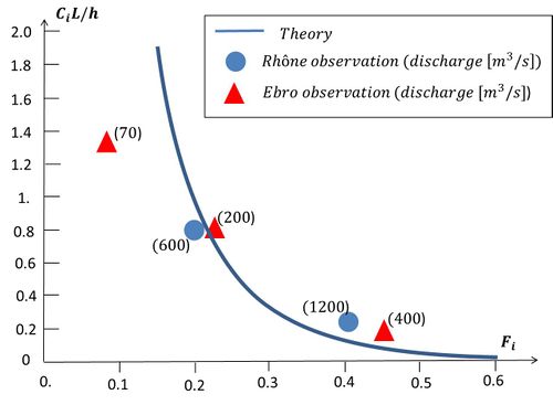
The dimensionless salt wedge length [math]C_i L / h[/math] as a function of the internal river Froude number [math]F_i[/math] is shown in figure 2. The condition at the sea boundary plays a crucial role for the salt wedge length. The depth of the river outflow layer is proportional to the river discharge at the power 2/3. Therefore the depth of the salt wedge layer becomes very small for high river discharge.
Comparison with observations
The Rhône (France) and the Ebro (Spain) are examples of estuaries with almost no tidal motion (both situated on the Mediterranean coast). Figure 2 shows the observed dimensionless salt wedge lengths [math]C_i L / h[/math] in these estuaries for different internal river Froude numbers [math]F_i[/math]. The observed lengths are compared with the theoretical result for a prismatic estuary (Eq. (7)). For low-medium discharges the correspondence with theory is fairly good. For very small river flow the model lengths are much larger than the observed intrusion lengths. This is due in particular to the presence of high sills in the upstream part of the Rhône estuary (at 35 km from the mouth) and Ebro estuary (at 32 km from the mouth). Other less pronounced sills situated downstream also tend to arrest the salt wedge for a certain range of river discharges; the salt wedge length [math]L[/math] therefore does not increase continuously as a function of [math]F_i[/math], as would be the case for a true prismatic canal.
Related articles
Seawater intrusion and mixing in estuaries
References
- ↑ Schijf, J.B., Schönfeld, J.C. (1953) Theoretical considerations on the motion of salt and fresh water. Proceedings of the 5th I.A.H.R. Congress, 321–333
- ↑ Geyer, R.W. and Farmer, D.H. (1989) Tide-induced variation of the dynamics of a salt wedge estuary. J. Phys. Oceanography 19: 1060-1072
- ↑ Abraham, G., Karelse, M. and Van Os, A.G. (1979) On the magnitude of the interfacial shear stress of subcritical stratified flows in relation with interfacial stability. Hydr. Res. 17: 273-287
- ↑ Ibanez, C., Pont, P. and Prat, N. (1997) Characterization of the Ebre and Rhone estuaries: A basis for defining and classifying salt-wedge estuaries. Limnol. Oceanograph. 42: 89-10
Please note that others may also have edited the contents of this article.
|