Portal:THESEUS/Gironde estuary
Gironde estuary is an estuary in South-West of France located on two regions: Aquitaine and Poitou Charentes. This is a common estuary of Garonne and Dordogne Rivers. It is the largest estuary in Western Europe. It is 75 km long, up to 12 km wide with an area of 635 km². This macrotidal estuary has a tide amplitude varying from 2 m to 5 m. This amplitude does not damp. On the contrary it increases from river mouth to upstream areas because of decreasing width and depth. This is an important navigation axis for container carriers, cruisers and fish shipping. It is in particular used for the transport of wings of A380 airplane from Saint-Nazaire to Pauillac. Traditional activities like fisheries are present as well as energetic activities like Pétrole du Bec refinery and Blayais nuclear power station. About forty harbours exist classed in three categories: industrial harbour, fish harbour and yachting. These harbours and mostly located slightly inland in order to be protected from tide currents. They occupy former swamps of Gironde.
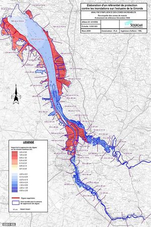
Hydraulic control of Gironde estuary is structured by navigation necessities required for harbour areas like Verdon, Pauillac, Blaye, Ambès, Bassens and Bordeaux. Navigation channels are characterised by a large depth, strong current velocities and turbidity. These navigation channels are maintained thanks to regular dredging operations and submersible dykes. Moreover Gironde estuary counts 130 km of dykes or levees on the Gironde district. This estimate represents 61 % of the referenced length of maritime dykes in France. Except the sea that constitutes 75 % of the estuary, 10 % of its area is covered by rivers, mudflats, sandbanks, and lagoons. Arable lands and forests cover each 5 % of estuary. Meadows, dunes and sand beaches share the remaining 5 %. This environment makes Gironde estuary the only natural estuary in Europe. In Gironde estuary a strong storm occurred in the evening of December 27th 1999. Winds of 173 km/h were measured in Cap Ferret and 144 km/h in Bordeaux. Winds, low barometric pressure, waves – but a medium tide – produced the submersion of the dykes protecting the nuclear power station and inundations of galleries. More generally this severe meteorological event surprised authorities by the intensity and the volume of damages.
Mitigation options in estuary: Twenty years of experience on diagnosis and repairing of Gironde banks are available. Inventory of dykes in the area is completed and a study of adaptation costs is in progress. Moreover several locals plans for flood prevention have been prepared in the last years. The main objective consists in damping tidal amplification in Gironde estuary by changing geometry of the estuary and roughness of the bed or banks.
Three main options will be investigated for this issue:
- managed realignment of the estuary. A new sea wall is built and the old sea wall is breached. This realignment has conservation and coastal defence benefits. Another option of using fuse dyke has been locally proposed. This option consists in washing the dyke away when the coastal flood overtops it and in inundating fields surrounded themselves by dykes. Quarry pit excavations in project could also be inundated after environmental assessment. This proposed realignment is likely to be coupled with hydroelectric micropower plant or with specific hydraulic works whose management should be optimised.
- changing bed roughness or bank roughness. Submersible groins can for instance be built along banks. Their effect on global roughness should be assessed.
- overdredging can reduce the depth effect that is partly responsible for tidal wave amplification. Dredging can surely lower the water height but we should analyse its sustainable effect in a very turbid river like Garonne.
Protection of the right bank of the estuary in the estuary mouth is the second objective. Even if wave height is less than 1 meter in the well sheltered Gironde estuary, wave set-up and run-up can lead to submersion of the right bank of the estuary. This process will be modified with the expected sea level rise since the natural wave breaking will be less important. That is why wave damping in the estuary mouth is an interesting mitigation option. Wave energy converters could be a very innovative coastal defence system. Without new coastal defence system, larger wave heights are expected. Options for upgrading existing dykes should be then studied.
- Area : 635 km²
- Dimensions: 75 km x 12 km
- Average Dordogne discharge : 380 m3/s
- Extreme Dordogne discharge : 4000 m3/s
- Average Garonne discharge: 630 m3/s
- Extreme Garonne discharge: 7 700 m3/s
- Maximum tidal volume flux: 7 000 m3/s


