Water quality services GMES - MarCoast in Germany
Contents
Introduction
Monitoring of the marine environment in German waters of the North Sea and the Baltic Sea has been performed since 1976 in the framework of the so called “Bund-Länder Messprogramm” BLMP (common measurement programme of the federation and the federal states). In the past, this programme has been focussed on physical and chemical parameters as required by the HELCOM (Baltic Sea) and OSPAR (North Sea) conventions. The EC Water Framework Directive and the Natura 2000 set of directives require complementary measurements of biological and morphological parameters in order to assess the water quality from an ecological point of view. The BLMP is currently being extended in this respect, and parameters derived from space=borne remote sensing are beginning to become an integral part of the programme. The European GMES programme will be a major contributor in this respect. In 1998 the Europe Commission decided to set-up the programme "Global Monitoring for Environment and Safety (GMES)". The aim is to provide services for users combining data from in-situ measurements, space observation and models. The services provide information and support policy decisions in terms of environment and security. GMES is a shared activity carried out by the European Commission in its research and development programme, and the European Space Agency (ESA) through its GMES Service Element (GSE) (Commission of the European Communities, 2003). GMES is currently in its implementation phase. As a long=term contribution to GMES, ESA is currently developing the Sentinel series of satellites, which deliver routinely- amongst others - information about the ocean state (surface height, waves, wind, temperature and ocean colour) over the next 20 years (Drinkwater et al., 2005[1]).
Methodology
MarCoast has the objective of delivering services to European users concerned with monitoring of the marine environment. The MarCoast Service Portfolio is composed of 2 service chains (Oil spill and Water Quality) containing 6 services:
- oil spill alert and polluter identification
- oil spill drift forecast
- water quality monitoring
- algae bloom detection and alert
- large scale water quality indicators
- MetOcean data
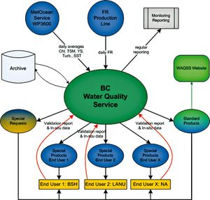
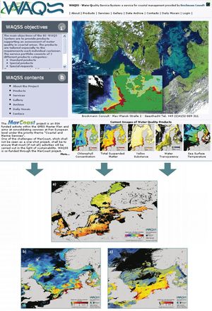
The Water Quality related services include products such as chlorophyll concentration, suspended matter concentration, turbidity, algal bloom indicators and sea surface temperature. In Germany, the DLR and Brockmann Consult are acting as regional MarCoast Service Providers, delivering products to the Federal Maritime and Hydrographic Agency (BSH), the Environmental Ministry of Schleswig-Holstein (LANU) and other monitoring agencies in Germany. The products are tailored to the needs of the agencies in the context of the BLMP. The products are operationally generated and published Europe wide through the MarCoast Services Portal and on the national scale via portals such as the Water Quality Service System (WAQSS, Fig. 2).
The WAQSS generates thematic maps by integrating the satellite data with in-situ measurements and delivers the results via electronic media. The validation of the services is an important component of MarCoast. The Validation Protocol requires intense user involvement in this process. Users contribute data, provide feedback and assess the quality of products and services (www.gmes-marcoast.com).Application
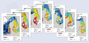
The MarCoast Services offered by Brockmann Consult are structured into standard and special products, and products generated on request. The standard products are basic datasets and thematic maps of the North Sea and the Baltic Sea, defined by Brockmann Consult and offered to every user. The special products and requests are designed to fit the needs of the different users. The requirements of the users are identified by the users and the WAQSS team and are fixed in so called Service Level Agreements (SLAs). The WAQSS production chain (Fig. 3) is taking MERIS Reduced Resolution products (1.2 km spatial resolution) and AATSR SST products (1 km spatial resolution) as input. An extension of the production chain using MERIS Full Resolution products is currently under construction. The processing of the raw data into thematic maps of algal bloom indicators, chlorophyll-a and total suspended matter concentration, yellow substance absorption and sea surface temperature is fully automated (WAQSS). An archive is maintained where all products are stored. Standard products are published on the WAQSS website, however, more important is the direct delivery of requested products to users and the feedbackloop, which is part of this direct communication line. The products are used to assess the quality of the seas and as decision support to guide in-situ sampling.
Validation
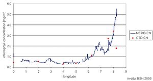
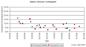
Validation of the MarCoast products is essential for their acceptance by the users. The validation protocol requires a close involvement of the users. In-situ measurements are statistically compared with the satellite derived products. For example, the BSH conducted a ship cruise in the North Sea in August 2006. Measurements of different parameters were performed along transects at defined locations. These data have been compared with MarCoast Water Quality products. Fig. 4 shows a correlation between in-situ and remote sensing methods. Another example is the validation of respective Water Quality products with in-situ data from the North Sea and the Baltic Sea taken by helicopter and from a ship by the LANU. Chlorophyll values derived from MERIS products were compared with in-situ measurements. In Fig. 5 data from one station are exemplarily plotted as a time series. A good agreement between the two data sources was found. A second aspect is the comparison of different algorithms, which are used to process the satellite data, to identify the best performing one for each area. This is particularly important for the optically complex waters of the North Sea and the Baltic Sea. In a case study the comparison included four algorithms: the standard MERIS Level 2 product, the standard MarCoast product, and a special method developed by the Freie Universität Berlin (FUB Case2 algorithm). The latter gave best results. Currently a dedicated Case 2 method is under development by GKSS which will be introduced in the MarCoast processing in 2008.
Perspectives
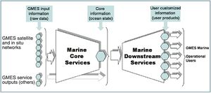
The preparatory phase of GMES is close to completion and after 2008 the system is going to enter into its operational phase. The European Space agency will be responsible for the space segment (Sentinel satellites) and the data portfolio, while the European Union is providing the service component. National supporting components are completing the system. The marine part of GMES is ensured by the Sentinels 1 and 3, complemented by the German TerraSAR-X and Rapid Eye satellites (Drinkwater et al., 2005[1]), and the Marine Core Service and Downstream Services of the EU, which are nationally accompanied by the DeMarine project. The operational/ commercial market of service providers and users completes the scenario which will evolve and grow over the next 20 years.
Copernicus
The GMES initiative has been integrated in the Copernicus programme in 2014. The objective of Copernicus is to use vast amount of global data from satellites and from ground-based, airborne and seaborne measurement systems to produce timely and quality information, services and knowledge, and to provide autonomous and independent access to information in the domains of environment and security on a global level. Copernicus is served by a set of dedicated satellites (the Sentinel families) and contributing missions (existing commercial and public satellites). The Sentinel satellites are specifically designed to meet the needs of the Copernicus services and their users. Since the launch of Sentinel-1A in 2014, the European Union set in motion a process to place a constellation of almost 20 more satellites in orbit before 2030. Copernicus also collects information from in situ systems such as ground stations, which deliver data acquired by a multitude of sensors on the ground, at sea or in the air. Copernicus services are dedicated to the monitoring and forecasting of the Earth's subsystems. They contribute directly to the monitoring of climate change. Copernicus services also address emergency management (e.g. in case of natural disaster, technological accidents or humanitarian crises) and security-related issues (e.g. maritime surveillance, border control).
References
- ↑ 1.0 1.1 Drinkwater, M., Rebhan, H., LeTraon, P.Y., Phalippou, L., Cotton, D., Johannessen, J., Ruffini, G., Bahurel, P., Bell, M., Chapron, B., Pinardi, N., Robinson, I., Santoleri, L. & Stammer, D. (2005). The Roadmap for a GMES Operational Oceanography Mission [electronic version], ESA Bulletin, 124, 43-48.
- ↑ 2.0 2.1 Ryder, P. (2007). GMES Fast Track Marine Core Service. Strategic Implementation Plan, Final version 24.04.2007 [electronic version].
Please note that others may also have edited the contents of this article.
|
Please note that others may also have edited the contents of this article.
|
