File list
This special page shows all uploaded files.
| Date | Name | Thumbnail | Size | User | Description | Versions |
|---|---|---|---|---|---|---|
| 16:27, 4 February 2024 | DeepwaterHorizonWikimedia.jpg (file) |  |
71 KB | Dronkers J | The Deepwater Horizon on fire. Photo Wikimedia. | 1 |
| 16:16, 4 February 2024 | PrestigeSinkingWikimedia.jpg (file) |  |
111 KB | Dronkers J | Sinking of the Prestige. Photo Wikimedia. | 1 |
| 16:00, 4 February 2024 | ExxonValdezShigenaka.jpg (file) |  |
63 KB | Dronkers J | Exxon Valdez at Outside Bay, May 1989. Photo credit Gary Shigenaka, NOAA. | 1 |
| 18:47, 19 January 2024 | ConvergingEstuarySchematization.jpg (file) |  |
259 KB | Dronkers J | Schematization of a strongly converging estuary. (a) Plan view; (b) 3D view. | 2 |
| 16:06, 15 January 2024 | WaveSpitLagoon.jpg (file) |  |
51 KB | Dronkers J | Schematic plan view of a wave-dominated estuary/lagoon semi-closed by a sand spit (highly oblique wave incidence). | 1 |
| 16:05, 15 January 2024 | WaveBarrierIslandLagoon.jpg (file) |  |
45 KB | Dronkers J | Schematic plan view of a wave-dominated estuary/lagoon with barrier island (close-to-normal wave incidence). | 1 |
| 16:04, 15 January 2024 | WaveTideBarrierIslandsEstuary.jpg (file) |  |
62 KB | Dronkers J | Schematic plan view of a wave- and tide-dominated estuary with barrier islands (close-to-normal wave incidence). | 1 |
| 16:03, 15 January 2024 | WaveTideSpitEstuary.jpg (file) |  |
57 KB | Dronkers J | Schematic plan view of a wave- and tide-dominated estuary (highly oblique wave incidence). | 1 |
| 15:52, 15 January 2024 | EstuaryColors.jpg (file) |  |
46 KB | Dronkers J | Colors in estuary planviews | 2 |
| 17:22, 27 December 2023 | MgmtRealignWallaseaIsland.jpg (file) |  |
142 KB | Dronkers J | Salt marsh restoration Wallasea Island, UK, by managed realignment. Photo credit John Akerman. | 2 |
| 13:12, 27 December 2023 | GrassCoveredSeadike.jpg (file) |  |
418 KB | Dronkers J | Grass covered dike, Wolphaartsdijk - Veerse Meer, Zeeland, Netherlands (Image Bank Rijkswaterstaat, photo Jan van den Broeke). | 1 |
| 12:28, 27 December 2023 | OysterReefConstructionEcoshapeSmall.jpg (file) |  |
82 KB | Dronkers J | Development of an oyster reef in the Eastern Scheldt (Netherlands) for protection against tidal flat erosion. Photo credit Ecoshape Building with Nature https://www.ecoshape.org/en/ | 1 |
| 11:55, 27 December 2023 | ReefBallEcoshape.jpg (file) |  |
83 KB | Dronkers J | Left: Reef balls. Right: Reef ball breakwater. Image credit Ecoshape Building with nature. https://www.ecoshape.org/en/ | 1 |
| 10:54, 27 December 2023 | ReefBallBreakwater.jpg (file) |  |
28 KB | Dronkers J | Reef ball breakwater. Image credit Ecoshape Building with Nature https://www.ecoshape.org/en/ | 1 |
| 21:35, 25 December 2023 | NematodeCaenorhabditisElegans.jpg (file) |  |
50 KB | Dronkers J | Nematode ''Caenorhabditis elegans''. Photo credit Bob Goldstein, UNC Chapel Hill | 1 |
| 21:30, 25 December 2023 | HarpacticoidCopepod.jpg (file) |  |
79 KB | Dronkers J | Harpacticoid copepod. Photo credit Lodewijk van Walraven. | 1 |
| 21:52, 13 December 2023 | PorePressureBuildUp.jpg (file) |  |
149 KB | Dronkers J | Time variation of pore water pressure at a certain depth. After Sui et al. 2020. | 2 |
| 17:44, 21 November 2023 | NourishmentLongshore.jpg (file) |  |
246 KB | Dronkers J | Evolution Gaussian-shape nourishment (a = 100 m, \sigma_0 = 1000 m) with littoral drift (<math>Q_0 = 4 \, 10^5 m^3/yr)</math> and berm height + closure depth <math>D = 8 m</math>. Blue curve: <math>t=0</math>, red curve <math>t=10 year</math>. No cross... | 1 |
| 19:37, 16 October 2023 | DistributionNonLinearWaves.jpg (file) |  |
54 KB | Dronkers J | The probability density distributions Eq. (C3) for <math>S=0</math> (blue) and <math>S=0.3</math> (red). | 1 |
| 19:36, 16 October 2023 | AiryFunction.jpg (file) |  |
41 KB | Dronkers J | The Airy function. | 1 |
| 19:28, 13 September 2023 | DuneFootRecovery.jpg (file) |  |
513 KB | Dronkers J | Examples of dune-foot retreat and recovery. 7a. Variation of the dune-foot position in a beach transect of the island Walcheren (Netherlands) over the period 1900-2010 (solid white line, based on annual surveys of Rijkswaterstaat <ref>Jeuken, C., Ruess... | 1 |
| 10:09, 20 August 2023 | WorldProdFisheryAquacultureFAO2020.jpg (file) |  |
73 KB | Dronkers J | Global trends in different types of fisheries, showing the fast increase of aquaculture. In 2020 the total aquaculture production (algae mariculture excluded) exceeded the production of capture (wild) fisheries. The production of inland aquaculture was... | 1 |
| 15:13, 10 August 2023 | EmilianiaHuxleyi.jpg (file) |  |
33 KB | Dronkers J | ''Emiliania huxleyi'' | 1 |
| 16:28, 7 August 2023 | Mytilus Edulis.jpg (file) |  |
6 KB | Dronkers J | ''Mytilus edulis'' | 1 |
| 16:26, 7 August 2023 | MagallanaGigas.jpg (file) |  |
8 KB | Dronkers J | ''Magallana gigas'' | 1 |
| 16:25, 7 August 2023 | AbraAlba.jpg (file) |  |
3 KB | Dronkers J | ''Abra alba'' | 1 |
| 16:25, 7 August 2023 | ArgopectenPurpuratus.jpg (file) |  |
7 KB | Dronkers J | ''Argopecten purpuratus'' | 1 |
| 17:36, 6 August 2023 | KelpGlobalDistribution.jpg (file) |  |
97 KB | Dronkers J | Global distribution of kelp species. From the Kelp Restoration Guidebook TNC-KFA-Kelp-Guidebook-2022.pdf | 1 |
| 09:23, 6 August 2023 | SeahorseSeagrassMeadow.JPG (file) |  |
99 KB | Dronkers J | Seahorse. Photo credit N. Garrick-Maidment | 1 |
| 15:32, 5 August 2023 | BeachScrapingOldBarBeach MidCoastNSW.jpg (file) |  |
217 KB | Dronkers J | Beach scraping Old Bar Beach New South Wales, Australia. Photo credit MidCoast Council. | 1 |
| 20:46, 22 July 2023 | ReefShape.jpg (file) |  |
46 KB | Dronkers J | Example of a typical reef shape. | 1 |
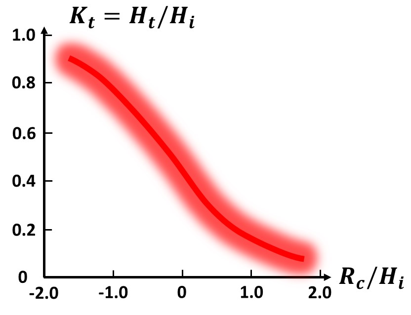
| 14:19, 4 July 2023 | WaveTransmissionGraph.jpg (file) | 44 KB | Dronkers J | Graphical estimate of the wave transmission coefficient as a function of the relative freeboard, based on laboratory data. The red glow of the curve indicates the level of accuracy. | 1 | |
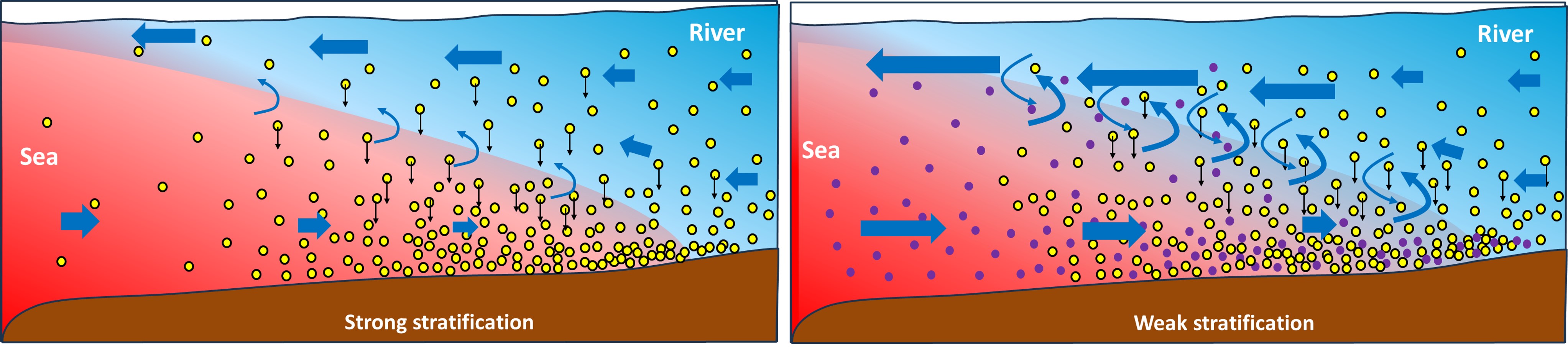
| 20:14, 1 July 2023 | StratificationETM.jpg (file) | 533 KB | Dronkers J | Cartoon explaining the effect of density stratification on the estuarine turbidity maximum (ETM). Red = sea water, blue = river water. Yellow dots = fluvial sediment, violet dots = marine sediment. Left panel: Strong stratification. Right panel: Weak s... | 1 | |
| 09:51, 25 June 2023 | TidalRangeHistory.jpg (file) |  |
112 KB | Dronkers J | Increase of the tidal range at inland seaports along tidal rivers in Europe during the past century. | 2 |
| 12:57, 24 June 2023 | ElbeTideHistory.jpg (file) |  |
46 KB | Dronkers J | Evolution of the HW and LW tidal levels in the Elbe at Hamburg in response to channel deepening in the past century. Adapted from ABP mer (2011). | 1 |
| 14:06, 23 June 2023 | AngleOfRepose.jpg (file) |  |
19 KB | Dronkers J | Angle of repose: Equilibrium slope angle of a pile of sediment grains in water. | 1 |
| 11:13, 23 June 2023 | StLawrenceTideAsym.jpg (file) |  |
90 KB | Dronkers J | Simultaneously recorded tide curves at different stations (km distance from Quebec town) along the St. Lawrence River. Adapted from LeBlond (1978). | 1 |
| 17:06, 22 June 2023 | StLawrenceTides.jpg (file) |  |
277 KB | Dronkers J | Tide gauge data at the St. Lawrence estuary mouth (Ste Anne des Monts) and at an upstream location (Trois Rivières) along the St. Lawrence River (Canada) during the month September 1976.The 0-meter datum is chosen arbitrarily for both stations. Redraw... | 2 |
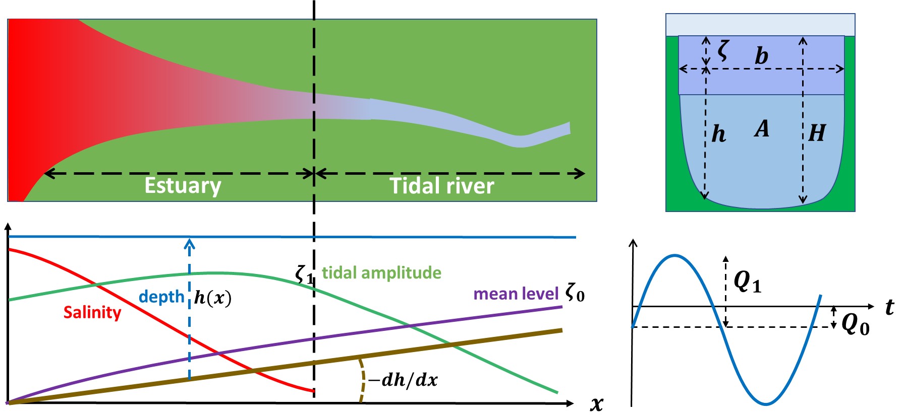
| 20:03, 21 June 2023 | TidalRiverScheme.jpg (file) |  |
167 KB | Dronkers J | Schematic representation of a tidal river and symbol definitions. | 1 |
| 19:19, 16 June 2023 | LoireGroins.jpg (file) |  |
632 KB | Dronkers J | Channel incision Loire tidal river. Left panel: Groins in the Loire tidal river near Anetz. Photo credit GIP Loire Estuaire. Right panel: Lowering of the river bed along the thalweg due to channel constriction. Redrawn from VNF (2019). | 1 |
| 09:25, 16 June 2023 | ScheldeTidalRiver.jpg (file) |  |
279 KB | Dronkers J | Floodplain of the Scheldt tidal river at low water, downstream of Gentbrugge. Photo credit Waterwegen en Zeekanaal NV. | 1 |
| 19:41, 15 June 2023 | TidalRiverDunes.jpg (file) |  |
108 KB | Dronkers J | Cross bedding of tidal river dunes. Panel a: Cross bed dipping (grain avalanches) to the right in unidirectional river flow. Panel b. Herringbone cross bedding. The flood flow has eroded the top of the river (ebb flow) dune, creating a flood cap with c... | 1 |
| 12:57, 6 June 2023 | MeanFriction.jpg (file) |  |
32 KB | Dronkers J | Contribution of friction to the mean water level gradient in a tidal river. | 1 |
| 12:57, 6 June 2023 | FrictionContributions.jpg (file) |  |
47 KB | Dronkers J | Contribution of friction to non-tidal and tidal components of the water level gradient in a tidal river. | 1 |
| 14:21, 22 May 2023 | ChenierPlainGuinee.jpg (file) |  |
220 KB | Dronkers J | Chenier plain in Guinée (West Africa). Image Google Earth. | 1 |
| 10:18, 22 May 2023 | ChenierFormation.jpg (file) |  |
107 KB | Dronkers J | Schematic of the stages of chenier formation. Top: Prograding mudflat including some sand and shells. Middle: Winnowing and offshore transport of mud by energetic wave action and onshore transport of the resulting sandy/shelly top layer. Bottom: Mudfla... | 1 |
| 20:59, 16 May 2023 | MandaraRip.jpg (file) |  |
184 KB | Dronkers J | Wave transmission over a submerged breakwater at Mandara beach, Alexandria (Egypt). The yellow arrows indicate the location of rip currents. | 1 |
| 15:03, 9 May 2023 | EnergyFlux.jpg (file) |  |
81 KB | Dronkers J | The longshore component of the wave energy flux trough the breaker depth contour per unit contour length is given by <math>F \cos\alpha \sin\alpha</math>. | 1 |
| 17:04, 8 May 2023 | NAOspectrum.jpg (file) |  |
63 KB | Dronkers J | Global NAO spectrum based on wavelet analysis of the NAO index annual time series for the period 1860-2005. Redrawn after Massei et al. (2007). | 1 |
| 16:24, 5 May 2023 | AlexandriaAbuQirBeach.JPG (file) |  |
385 KB | Dronkers J | Abu Qir beach, Alexandria. | 1 |