File list
This special page shows all uploaded files.
| Date | Name | Thumbnail | Size | User | Description | Versions |
|---|---|---|---|---|---|---|
| 13:53, 4 April 2007 | ArgusWorld.png (file) |  |
136 KB | Cohen | Argus map of the world | 1 |
| 10:20, 4 April 2007 | Theme9.png (file) |  |
77 KB | Cliviahaese | 1 | |
| 10:14, 4 April 2007 | Theme9.PNG (file) |  |
77 KB | Cliviahaese | 1 | |
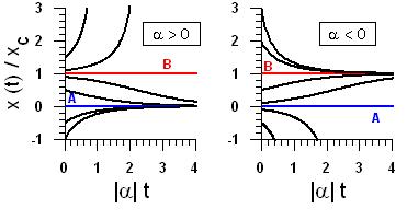
| 12:58, 3 April 2007 | Stability1.jpg (file) |  |
16 KB | Falques | 1 | |
| 12:28, 3 April 2007 | Stability1.JPG (file) |  |
16 KB | Falques | 2 | |
| 12:23, 3 April 2007 | Stability.JPG (file) |  |
16 KB | Falques | 2 | |
| 11:58, 3 April 2007 | Stability.jpg (file) |  |
36 KB | Falques | 1 | |
| 15:53, 2 April 2007 | Caixa1.jpg (file) |  |
71 KB | Falques | 1 | |
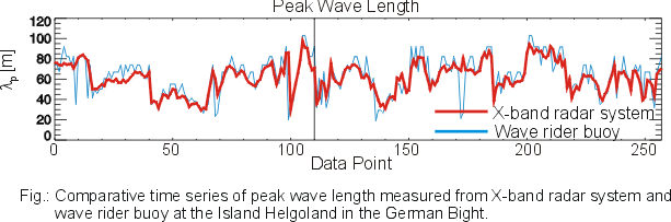
| 15:53, 2 April 2007 | HEL Lp time.png (file) |  |
35 KB | InaTrankmann | Fig.: Comparative time series of peak wave length measured from X-band radar system and wave rider buoy at the Island Helgoland in the German Bight. | 1 |
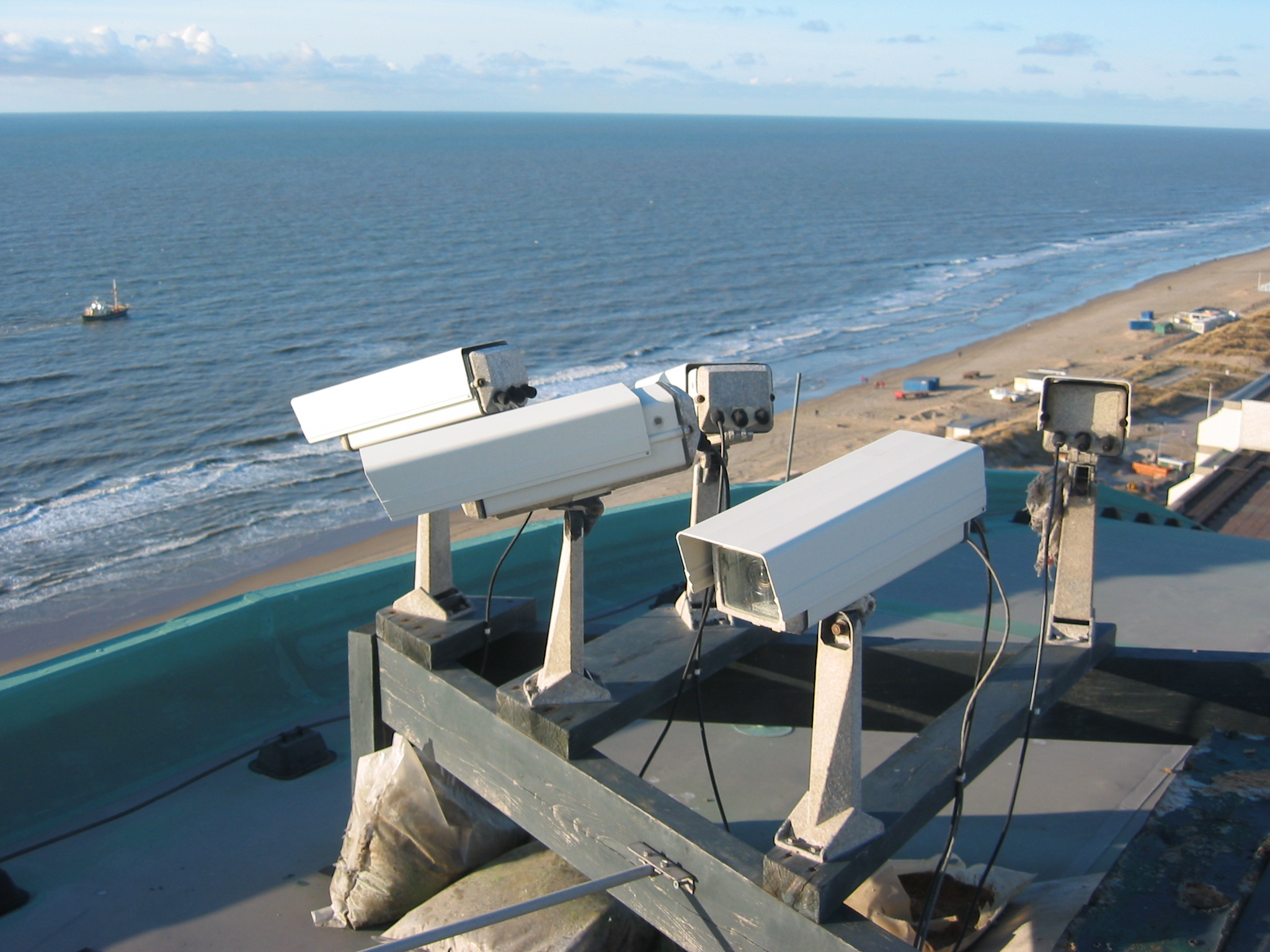
| 11:45, 2 April 2007 | CameraNoordwijk.JPG (file) |  |
648 KB | Cohen | Argus video cameras in Noordwijk aan Zee | 1 |
| 11:27, 1 April 2007 | HEL Tp Dir time.png (file) |  |
59 KB | InaTrankmann | Comparative time series of peak wave period and peak wave direction measured from X-band radar system and wave rider buoy at the Island Helgoland in the German Bight. | 1 |
| 11:05, 1 April 2007 | EKF Hs 2000.png (file) |  |
34 KB | InaTrankmann | Comparative time series of significant wave height measured from X-band radar system and wave rider buoy on board 2/4k Ekofisk platform in the North Sea. | 1 |
| 10:39, 1 April 2007 | QST 02052100 D2S.png (file) |  |
122 KB | InaTrankmann | 2-Dimensional Frequency-Direction Spectrum obtained by a X-band radar system on board a vessel. | 1 |
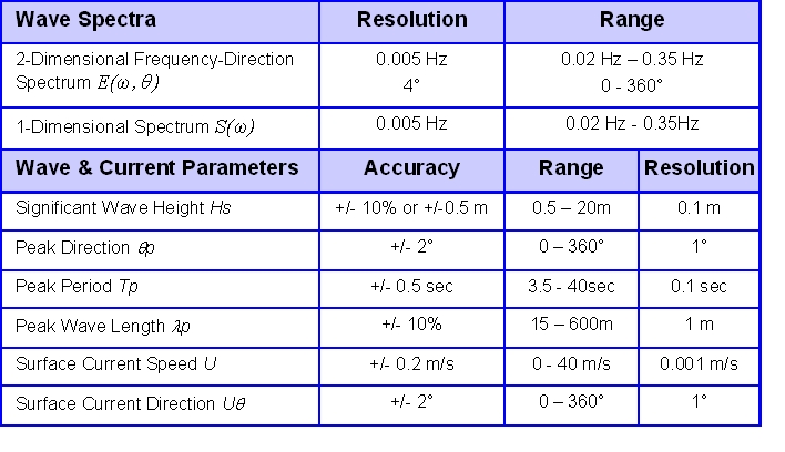
| 10:27, 1 April 2007 | Accuracy.png (file) |  |
43 KB | InaTrankmann | Standard output parameters of a X-dand radar system with corresponding resolutions, ranges, and accuracy. | 2 |
| 10:24, 1 April 2007 | QST 02052100pol.png (file) |  |
148 KB | InaTrankmann | Example of a radar image obtained on board a vessel. | 1 |
| 10:18, 1 April 2007 | Radar system.png (file) |  |
107 KB | InaTrankmann | Components of a X-band radar system | 1 |
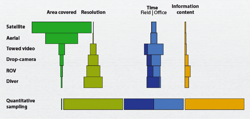
| 17:52, 31 March 2007 | UWVideo Fig1.png (file) |  |
101 KB | Pjo | Figure 1 in Underwater Video, showing relations between different mapping methods. | 1 |
| 15:13, 31 March 2007 | Figure 3.JPG (file) |  |
57 KB | BELORGEY Michel | 1 | |
| 14:01, 31 March 2007 | Accuracy3.jpg (file) |  |
121 KB | InaTrankmann | 1 | |
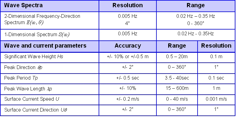
| 13:49, 31 March 2007 | Accuracy.jpg (file) |  |
121 KB | InaTrankmann | 1 | |
| 17:05, 30 March 2007 | Dimi biomarkers5.jpg (file) |  |
40 KB | Francoishissel | 1 | |
| 17:05, 30 March 2007 | Dimi biomarkers4.jpg (file) | 24 KB | Francoishissel | 1 | ||
| 17:05, 30 March 2007 | Dimi biomarkers3.jpg (file) |  |
15 KB | Francoishissel | 1 | |
| 17:05, 30 March 2007 | Vouvalidispic3.jpg (file) |  |
397 KB | Kpavlop | Fig. 3: The coastal terraces formation due to the erosional action of waves on the eastern coast of the Thermaikos Gulf. | 1 |
| 17:05, 30 March 2007 | Dimi biomarkers2.jpg (file) |  |
31 KB | Francoishissel | 1 | |
| 17:04, 30 March 2007 | Dimi biomarkers1.jpg (file) |  |
22 KB | Francoishissel | 1 | |
| 16:59, 30 March 2007 | Vouvalidispic2.jpg (file) |  |
98 KB | Kpavlop | Figure 2: Holocene reconstruction of the growth of the deltaic plain of Thessaloniki (Fouache et al., in press). | 1 |
| 16:57, 30 March 2007 | Vouvalidispic1.jpg (file) |  |
80 KB | Kpavlop | Figure 1. Location of the study area together with the type of coasts found in the North Thermaikos Gulf and the Thessaloniki Bay. | 1 |
| 16:50, 30 March 2007 | Pavlopoulospic3.jpg (file) |  |
56 KB | Kpavlop | 1 | |
| 16:47, 30 March 2007 | Pavlopoulospic2.jpg (file) |  |
41 KB | Kpavlop | 1 | |
| 16:47, 30 March 2007 | Pavlopoulostable1.jpg (file) |  |
67 KB | Kpavlop | 1 | |
| 16:44, 30 March 2007 | Pavlopoulospic1.jpg (file) |  |
24 KB | Kpavlop | Fig 1. The distribution of the five coastal types by geographical department. Worthnoting is the great extent of low lying coasts (deltaic plains and lagoons) in Thrace (88 %). On the contrary, the steep coasts comprise about 2/3 of the coasts of Thess | 1 |
| 15:58, 29 March 2007 | Image010.JPG (file) |  |
35 KB | Jan van de Graaff | 1 | |
| 15:31, 29 March 2007 | Image009.JPG (file) |  |
15 KB | Jan van de Graaff | 1 | |
| 14:20, 29 March 2007 | RDCP Scheme.png (file) |  |
61 KB | Friedwartzeimer | 1 | |
| 14:20, 29 March 2007 | Rdcp result new.jpg (file) |  |
150 KB | Friedwartzeimer | 1 | |
| 14:17, 29 March 2007 | RDCP result new.png (file) | Error creating thumbnail: File missing |
288 KB | Friedwartzeimer | 1 | |
| 13:53, 29 March 2007 | Radargeometrie.png (file) |  |
84 KB | Friedwartzeimer | 4 | |
| 12:54, 29 March 2007 | Image006.JPG (file) |  |
43 KB | Jan van de Graaff | 1 | |
| 12:49, 29 March 2007 | Image005.JPG (file) | Error creating thumbnail: File missing |
43 KB | Jan van de Graaff | 3 | |
| 11:39, 29 March 2007 | Image007.JPG (file) |  |
29 KB | Jan van de Graaff | 2 | |
| 11:09, 29 March 2007 | Image003.JPG (file) |  |
69 KB | Jan van de Graaff | 1 | |
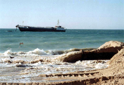
| 15:44, 28 March 2007 | Technical solution.jpg (file) |  |
106 KB | Lpneves | Dredging operations (source: [http://www.dragapor.com/ DRAGAPOR - Dragagens de Portugal, S.A.]). | 1 |
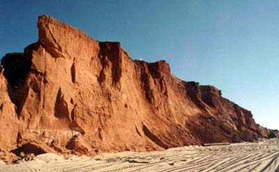
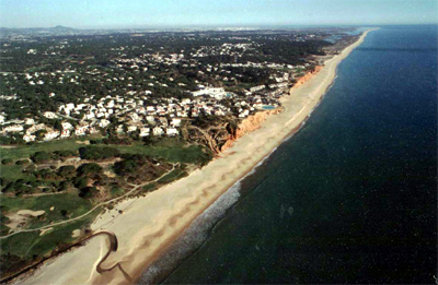
| 15:43, 28 March 2007 | Red cliffs.jpg (file) |  |
24 KB | Lpneves | Red sand cliffs (source: [http://www.dragapor.com/ DRAGAPOR - Dragagens de Portugal, S.A.]). | 1 |
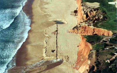
| 15:42, 28 March 2007 | Beach during.jpg (file) |  |
124 KB | Lpneves | Vale do Lobo beach during the artificial sand nourishment operation (source: [http://www.dragapor.com/ DRAGAPOR - Dragagens de Portugal, S.A.]). | 1 |
| 15:41, 28 March 2007 | Beach before.jpg (file) |  |
117 KB | Lpneves | Vale do Lobo beach before the artificial sand nourishment operation (source: DRAGAPOR - Dragagens de Portugal, S.A.). | 1 |
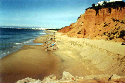
| 15:37, 28 March 2007 | Beach after.jpg (file) |  |
114 KB | Lpneves | Vale do Lobo beach after the artificial sand nourishment operation (source: DRAGAPOR - Dragagens de Portugal, S.A.). | 1 |
| 12:54, 28 March 2007 | Achtung-90.gif (file) |  |
3 KB | Thijs Damsma | source: http://commons.wikimedia.org/wiki/Image:Important.svg | 1 |
| 12:54, 28 March 2007 | Achtung-70.gif (file) |  |
3 KB | Thijs Damsma | source: http://commons.wikimedia.org/wiki/Image:Important.svg | 1 |
| 12:54, 28 March 2007 | Achtung-50.gif (file) |  |
2 KB | Thijs Damsma | source: http://commons.wikimedia.org/wiki/Image:Important.svg | 1 |