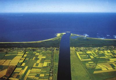
Vistula delta plain
Gdansk is situated in the Vistula delta plain, part of the town was built in depression area. The Gulf of Gdańsk (Zatoka Gdanska) is located in the southeast part of the Baltic Sea and stretches from Cape Rozewie (Poland) to Cape Taran (Russia, Kaliningrad district). The Gulf of Gdańsk is characterized by a high diversity of the environment (different types of coastlines – under preservation and not being conserved, 6 areas covered by NATURE 2000, 19 nature reserves, 3 landscape parks located in the Gulf and in the area adhering directly thereto), economic (industry, ports, fishery, agriculture) as well as social (urban agglomerations, recreation areas also agricultural ones, rapid development of housing and transport infrastructure). The coast of the Gulf features two very long sand spits: Hel Peninsula and Vistula Spit. The first one constitutes the northeast boundary of the Puck Bay (which is open at its southeast part), while the second one almost entirely separates the Vistula Lagoon (Zalew Wislany) from the Gulf of Gdańsk. The western part of the Gulf of Gdańsk is formed by a shallow water internal part of the Puck Bay. The types of coastlines are diversified : cliffs, dunes, beaches and also hydro engineering development (ports, promenades, quays). Also the preservation methods vary – from refulation to a use of concrete. The ports located in the Gulf of Gdańsk fulfil different economic functions and serve different types of activities. The main port functions are maritime merchandise, fishing boats operation, passenger transport and marine recreational boating. Gdańsk is a major city in the region and is an important industrial harbour city with shipyards. Together with Sopot and Gdynia, they form metropolitan area called Tricity, with population of almost 800’000. The area of Gdańsk is very much urbanised and the amount of built-up areas around the city is still increasing, what causes a considerable reduction in water retention. Extreme floods have been one of the most frequent danger responsible for many deaths and economic losses in Gdansk. The greatest threats to the town and its environs are: storm-surges on the southern coasts of the Baltic Sea, especially, when an ice-jamming occurs in the estuary (over 70%), big flood-waves on the Wisla river and local rivers, floods due to technical failures, e.g. breaks in the dikes, damage of a pumping station or of the flood-gate in the depression quarter of the town.
The Hel Peninsula has a population of about 10,000 (313 inhabitants per 1 km2, about 2.5 times more than the mean population density in Poland), while there are at least 5 times more people during the summer season. Hel Peninsula is protected by heavy seawalls and groins as well as by use of artificial beaches and dunes. In the past, some material for artificial beach fills was delivered from the Puck Bay (the inner side of Hel Peninsula). Deep underwater excavations in the Puck Bay, caused serious ecological problems, so that further dredging had to be stopped there. The flood hazard would increase (SEAREG, ASTRA projects) because of accelerated sea level rise and increased frequency of heavy storms. For the last 100 years the average sea level in Gdansk rose about 1.5 mm/year. Beginning from the 50. this rate increased to 5 mm/year. The frequency of dangerous storms increased in the Gulf of Gdansk from 11 incidents in the ‘60 to 38 in the ‘80. In unfavourable conditions therise in sea level may exceed 1.5 m. One of the most catastrophic floods in Gdansk occurred in April 1829, when 75% of the contemporary city area were under water. Up to present days five marks of the highest water stand survive on the walls of buildings in the Old Town indicating 3.36 m above mean sea level. Also after the Second World War part of the city was flooded because damages of dykes and dams at the area of Vistula Delta Plain. At the moment Gdansk is one of the best flood protected cities in Poland - it has a network of flood protection infrastructure, i.e. dikes, ditches, culverts, sluices, pumping stations and storage reservoirs. Recurring flood events with severe impacts have led to analysis of existing flood protection policies as well as analysis of technical condition and modernization of the infrastructure, however climate change impacts have not been taken into account so far in an integrated approach in the water and flood risk management. Division in the risk management is diversified as well – coastal waters with adjacent technical land strip are under management of the maritime administration whereas inland waters under the Regional Water Management Administration and the on-shore areas administered by local administration offices. The centre of Disaster Risk Reduction, aimed at counteracting any effects of crisis. In case of natural threat from the sea (storms etc.) impending over life, property and coasts, all actions undertaken by the above mentioned bodies have to be supported by warnings, issued and announced by the national hydro-meteorological service (IMGW).

