Difference between revisions of "Guria Coastal Region"
| Line 14: | Line 14: | ||
<br style="clear:both;"/> | <br style="clear:both;"/> | ||
[[Image:guria1.jpg|300px|thumb|right|British Petroleum Terminal in the river Supsa area (Photo: Patrick Breslin)]] | [[Image:guria1.jpg|300px|thumb|right|British Petroleum Terminal in the river Supsa area (Photo: Patrick Breslin)]] | ||
| + | |||
<u>'''Main coastal issues'''</u> | <u>'''Main coastal issues'''</u> | ||
| Line 32: | Line 33: | ||
- Improvement of erosion control and watershed management | - Improvement of erosion control and watershed management | ||
| − | |||
| − | |||
<br style="clear:both;"/> | <br style="clear:both;"/> | ||
| Line 58: | Line 57: | ||
Indicators - LEAC - Participatory methods | Indicators - LEAC - Participatory methods | ||
| − | |||
Revision as of 21:49, 29 June 2011
CASE description
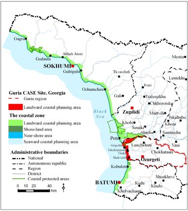
Guria Coastal Region is located along the Black Sea coast of Georgia, spreading approx. 21.5 km from River Natanebi to the southern edge of the city of Poti. Two main landscape types are the coastal plains, dominated by agriculture, which are characterised by flat, open landscapes with distant views of the Caucasus Mountains, and foothills of the Lesser Caucasus. In the area from River Natanebi to River Supsa is present an important cluster of tourism activities (Ureki resort with its black sand beaches). Within this area, the British Petroleum controls Supsa oil terminal with 4 x 40,000 m3 storage capacity. Construction of a new Supsa port and related infrastructure was recently approved in the same area. The coastal substrata here is comprised of coarse to fine sands. The coastline just south of Poti is relatively undeveloped, while Grigoleti and Shekvetili settlements contain uncontrolled dacha (summer house) developments.
ICZM phase
Establishment
Main coastal issues
- Bathing water quality and beach litter
- Weak quality of EIA process in coastal development projects, such as new Supsa port
- Inadequate erosion control
- Habitat loss
Objectives
- Development of coastal management tools
- Improvement of erosion control and watershed management
End Products
Application of ICZM indicators - SDI - Change detection
Tools foreseen to be developed and used
ndicators - LEAC - Participatory methods - SDI
Other tools to be applied
EIA - Remote sensing - Watershed modelling
Training needs
Indicators - LEAC - Participatory methods
CASE Responsibles
Mamuka Gvilava - Black Sea Commission Permanent Secretariat (BSC PS) - email: MGvilava@ICZM.ge
Amiran Gigineishvili - Georgia CASE Coordinator - email: lanchkhuti@civitas.ge


