Difference between revisions of "Nile Delta"
(New page: Nile delta (Egypt): a low lying area of the Nile delta comprising lagoons and wetlands with a length of about 118 km. The area hosts 14 million person and the resident are situated at the...) |
|||
| Line 1: | Line 1: | ||
| − | + | [[Image: Nile_delta_map.jpg|380px|thumb|left]] | |
| − | + | <u>'''CASE description'''</u> | |
| − | + | ||
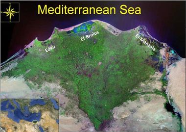
| − | + | The CASE is characterised by a fluvio-marine delta, a low lying coast with lagoon and wetlands (Idku and El- Brulus), its coastal length is about 180 km. The Delta is composed of 7 main administrative units (Governorates). Almost 14 million person residents are situated at the narrow strip around the Nile River. Prevailing land/sea uses are: agriculture tourism, fisheries, industry, maritime and Oil and gas exploration. | |
| − | + | ||
| + | [[Image:Nile_delta_map_2.jpg|300px|thumb|right|Maritime and municipal activities in the Sevastopol Bay]] | ||
| + | |||
| + | <u>'''ICZM phase'''</u> | ||
| + | |||
| + | Establishment | ||
| + | |||
| + | |||
| + | <u>'''Main coastal issues'''</u> | ||
| + | |||
| + | - Fishery | ||
| + | |||
| + | - Climate change effects such as erosion | ||
| + | |||
| + | - Land use | ||
| + | |||
| + | |||
| + | |||
| + | <u>'''Objectives'''</u> | ||
| + | |||
| + | - To develop adaptation strategies to climate change | ||
| + | |||
| + | - To increase fishermen well-being | ||
| + | |||
| + | - To develop planning options for decision makers | ||
| + | |||
| + | |||
| + | |||
| + | |||
| + | [[image: Nile_delta.jpg|300px|thumb|left|Idku lake (Author: Suzan Kholeif)]] | ||
| + | |||
| + | |||
| + | <u>'''End Products'''</u> | ||
| + | |||
| + | Plans-strategic vision-strategy and organisational design, with respect to: | ||
| + | |||
| + | - adaptation policy | ||
| + | |||
| + | - support of local communities in designing-implementing local development plans with particular reference to fishery and mariculture. | ||
| + | |||
| + | |||
| + | |||
| + | <u>'''Tools foreseen to be developed and used'''</u> | ||
| + | |||
| + | Indicators - LEAC - Scenarios - Participatory methods | ||
| + | |||
| + | |||
| + | <u>'''Training needs'''</u> | ||
| + | |||
| + | LEAC - Scenarios - Participatory methods | ||
| + | |||
| + | <br style="clear:both;"/> | ||
| + | <u>'''CASE Responsible'''</u> | ||
| + | |||
| + | Susan Kholeif - National Institute of Oceanography and Fisheries - Suzan_Kholeif@yahoo.com | ||
Revision as of 20:59, 29 June 2011
CASE description
The CASE is characterised by a fluvio-marine delta, a low lying coast with lagoon and wetlands (Idku and El- Brulus), its coastal length is about 180 km. The Delta is composed of 7 main administrative units (Governorates). Almost 14 million person residents are situated at the narrow strip around the Nile River. Prevailing land/sea uses are: agriculture tourism, fisheries, industry, maritime and Oil and gas exploration.
ICZM phase
Establishment
Main coastal issues
- Fishery
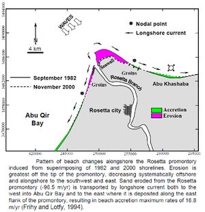
- Climate change effects such as erosion
- Land use
Objectives
- To develop adaptation strategies to climate change
- To increase fishermen well-being
- To develop planning options for decision makers
End Products
Plans-strategic vision-strategy and organisational design, with respect to:
- adaptation policy
- support of local communities in designing-implementing local development plans with particular reference to fishery and mariculture.
Tools foreseen to be developed and used
Indicators - LEAC - Scenarios - Participatory methods
Training needs
LEAC - Scenarios - Participatory methods
CASE Responsible
Susan Kholeif - National Institute of Oceanography and Fisheries - Suzan_Kholeif@yahoo.com


