Difference between revisions of "Bouches du Rhône"
| Line 1: | Line 1: | ||
| − | [[Image:Bouches_du_rhone_map.jpg| | + | [[Image:Bouches_du_rhone_map.jpg|380px|thumb|left]] |
'''[[CASE description:]]''' | '''[[CASE description:]]''' | ||
Revision as of 19:21, 29 June 2011
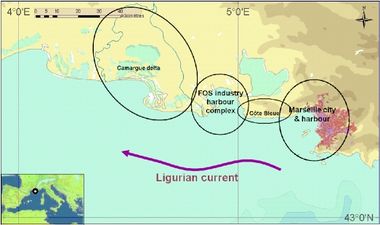
The Coast of the Bouches du Rhone (120 km) is characterised by calanques (rocky shore), urban, industrial zone, delta, sandy beaches. In the dyked area of the Camargue, the sea has gained the upper hand, in part because modification in the hydrological regime and because incursions by the sea are increasing (due to subsidence and the rising level of the Mediterranean).
Establishment
Conflicting uses among:
- port area and wetlands;
- protected areas and recreational activities;
- urbanisation and wetlands;
- pollution caused by industries, urban waste, agriculture.
To implement and test tools that can help decision makers and stakeholders to:
- share a common view of the dynamics and the possible futures of this complex territory where multiple anthropogenic pressures are exerted.
- take appropriate measures to preserve coastal ecosystem services.
- manage interactions between coastal conflicting usages.
Demonstration of selected tools/methods (economic assessment and LEAC for BdR) in the CASE
Tools foreseen to be developed and used:
LEAC - Economic Assessment (greening account)
LEAC - Economic Assessment
Jean-François Cadiou - Ifremer - email: Jean.Francois.Cadiou@ifremer.fr
Lisa Ernoul - Tour du Valat - email:ernoul@tourduvalat.org


