Difference between revisions of "Arnemuiden and its fishing history"
| Line 5: | Line 5: | ||
Since its founding, early 1200, Arnemuiden was situated at the edge of the island Walcheren, close to the sea. The island in the province of Zeeland, is situated in the southwest of the Netherlands. Arnemuiden became quite an important trading city with a harbour where lots of trading vessels landed until into the 16th Century. The city of Middelburg dug in 1532 a channel from the city to the open sea, the harbour of Arnemuiden silted and the city got destroyed in the eighty year war with the Spanish in 1572. In the Golden Age the city of Arnemuiden was eclipsed by its neighbouring city Middelburg. The flourishing and wealthy period of Arnemuiden ended. | Since its founding, early 1200, Arnemuiden was situated at the edge of the island Walcheren, close to the sea. The island in the province of Zeeland, is situated in the southwest of the Netherlands. Arnemuiden became quite an important trading city with a harbour where lots of trading vessels landed until into the 16th Century. The city of Middelburg dug in 1532 a channel from the city to the open sea, the harbour of Arnemuiden silted and the city got destroyed in the eighty year war with the Spanish in 1572. In the Golden Age the city of Arnemuiden was eclipsed by its neighbouring city Middelburg. The flourishing and wealthy period of Arnemuiden ended. | ||
| − | + | [[File:Waghenaer.jpg|352px]] | |
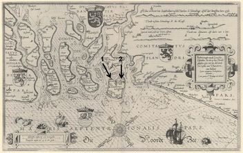
| + | Figure 1: Arnemuiden (1) and Middelburg (2) in 1583. Waghenaer (1584, map 03)<ref>[http://www.vliz.be/nl/imis?module=ref&refid=69444 1. Waghenaer, L.J.; Skelton, R.A. (1964). Lucas Jansz Waghenaer Spieghel der Zeevaerdt Leyden 1584-1585. Theatrum Orbis Terrarum Series of Atlases in Facsimile, First series(Volume IV). Meridian Publishing/N. Israel: Amsterdam. XI, 23 maps, 5-40, 22 maps pp.]</ref>. | ||
One of the industries that helped Arnemuiden centuries later, in the 19th century, escaping poverty and regaining its pride was the fishing industry. Arnemuiden had since the middle of the 18th century a wharf where hundreds of fishing vessels were built. Fishing and catching shrimps became so important that in 1870 two thirds of the 1.675 inhabitants of Arnemuiden earned their living in the fishing industry. Infrastructure works, like a railway connecting the island Walcheren with the Mainland in 1872 and the construction of a dam in 1961 meant for Arnemuiden the end of fishing facilities and presence of their vessel fleet in their harbour. Arnemuiden didn’t have a connection with the open sea anymore, and had less and less that reminded the village of its fishing history. Most of the vessel fleet of Arnemuiden had moved to Veere and Vlissingen. | One of the industries that helped Arnemuiden centuries later, in the 19th century, escaping poverty and regaining its pride was the fishing industry. Arnemuiden had since the middle of the 18th century a wharf where hundreds of fishing vessels were built. Fishing and catching shrimps became so important that in 1870 two thirds of the 1.675 inhabitants of Arnemuiden earned their living in the fishing industry. Infrastructure works, like a railway connecting the island Walcheren with the Mainland in 1872 and the construction of a dam in 1961 meant for Arnemuiden the end of fishing facilities and presence of their vessel fleet in their harbour. Arnemuiden didn’t have a connection with the open sea anymore, and had less and less that reminded the village of its fishing history. Most of the vessel fleet of Arnemuiden had moved to Veere and Vlissingen. | ||
If one would walk in Arnemuiden, at first sight not much reminded of the rich fishing history of Arnemuiden. Strange enough though, talking to the inhabitants of Arnemuiden, the reality appears to be different. They still felt themselves a fishing community, with a strong social cohesion, in some regards also rather closed and isolated. Also a lot of residents still work in the fishing industry in the earlier mentioned neighbouring cities like Veere and Vlissingen. Some say that four to five hundred people are still working in the fishing industry, which the official figures don’t show, because they are enrolled in Veere or Vlissingen. | If one would walk in Arnemuiden, at first sight not much reminded of the rich fishing history of Arnemuiden. Strange enough though, talking to the inhabitants of Arnemuiden, the reality appears to be different. They still felt themselves a fishing community, with a strong social cohesion, in some regards also rather closed and isolated. Also a lot of residents still work in the fishing industry in the earlier mentioned neighbouring cities like Veere and Vlissingen. Some say that four to five hundred people are still working in the fishing industry, which the official figures don’t show, because they are enrolled in Veere or Vlissingen. | ||
| + | |||
| + | [[File:Arnemuiden.png|500px]] | ||
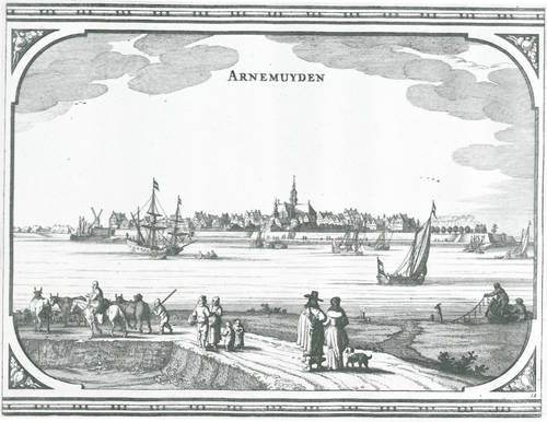
| + | Figure 2: ''Arnemuiden viewed from the South with in the foreground on the left a flock of sheep and some cows. To their right there is a married couple of the propertied classes and we may see some fishermen who are fishing with the ‘reepe’ (cord with fish-hooks at regular distances). A man-of-war, boats and an inland yacht are visible on the water.'' (Speculum Zelandiae 1660,<ref>[http://www.vliz.be/nl/imis?module=ref&refid=122720 Gittenberger, F.; Weiss, H. (1983). Zeeland in oude kaarten. Lannoo: Tielt. ISBN 90-209-1121-X. 160 pp]</ref>) | ||
| + | |||
| + | ===<span style="color:#3a75c4; Font-size: 130%">'''<small>References</small>'''</span>=== | ||
| + | <references/> | ||
| + | |||
{{GIFS}} | {{GIFS}} | ||
Revision as of 14:20, 31 July 2014
Arnemuiden and its fishing history
The city of Arnemuiden, today a small village of 5.000 residents, has been for a long time a fishing community and in a way for some time it hasn’t. Since its founding, early 1200, Arnemuiden was situated at the edge of the island Walcheren, close to the sea. The island in the province of Zeeland, is situated in the southwest of the Netherlands. Arnemuiden became quite an important trading city with a harbour where lots of trading vessels landed until into the 16th Century. The city of Middelburg dug in 1532 a channel from the city to the open sea, the harbour of Arnemuiden silted and the city got destroyed in the eighty year war with the Spanish in 1572. In the Golden Age the city of Arnemuiden was eclipsed by its neighbouring city Middelburg. The flourishing and wealthy period of Arnemuiden ended.
 Figure 1: Arnemuiden (1) and Middelburg (2) in 1583. Waghenaer (1584, map 03)[1].
One of the industries that helped Arnemuiden centuries later, in the 19th century, escaping poverty and regaining its pride was the fishing industry. Arnemuiden had since the middle of the 18th century a wharf where hundreds of fishing vessels were built. Fishing and catching shrimps became so important that in 1870 two thirds of the 1.675 inhabitants of Arnemuiden earned their living in the fishing industry. Infrastructure works, like a railway connecting the island Walcheren with the Mainland in 1872 and the construction of a dam in 1961 meant for Arnemuiden the end of fishing facilities and presence of their vessel fleet in their harbour. Arnemuiden didn’t have a connection with the open sea anymore, and had less and less that reminded the village of its fishing history. Most of the vessel fleet of Arnemuiden had moved to Veere and Vlissingen. If one would walk in Arnemuiden, at first sight not much reminded of the rich fishing history of Arnemuiden. Strange enough though, talking to the inhabitants of Arnemuiden, the reality appears to be different. They still felt themselves a fishing community, with a strong social cohesion, in some regards also rather closed and isolated. Also a lot of residents still work in the fishing industry in the earlier mentioned neighbouring cities like Veere and Vlissingen. Some say that four to five hundred people are still working in the fishing industry, which the official figures don’t show, because they are enrolled in Veere or Vlissingen.
 Figure 2: Arnemuiden viewed from the South with in the foreground on the left a flock of sheep and some cows. To their right there is a married couple of the propertied classes and we may see some fishermen who are fishing with the ‘reepe’ (cord with fish-hooks at regular distances). A man-of-war, boats and an inland yacht are visible on the water. (Speculum Zelandiae 1660,[2])
References
- ↑ 1. Waghenaer, L.J.; Skelton, R.A. (1964). Lucas Jansz Waghenaer Spieghel der Zeevaerdt Leyden 1584-1585. Theatrum Orbis Terrarum Series of Atlases in Facsimile, First series(Volume IV). Meridian Publishing/N. Israel: Amsterdam. XI, 23 maps, 5-40, 22 maps pp.
- ↑ Gittenberger, F.; Weiss, H. (1983). Zeeland in oude kaarten. Lannoo: Tielt. ISBN 90-209-1121-X. 160 pp