Difference between revisions of "Al Hoceima coast"
m |
|||
| Line 14: | Line 14: | ||
Setting the vision | Setting the vision | ||
| + | |||
| Line 53: | Line 54: | ||
Scenarios - Participatory methods | Scenarios - Participatory methods | ||
| − | |||
<br style="clear:both;"/> | <br style="clear:both;"/> | ||
Revision as of 19:54, 29 June 2011
CASE description
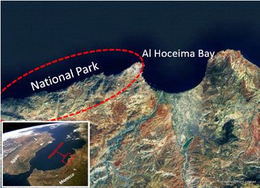
The coast of Al Hoceima is located in the central part of the northern of Morocco, along the Mediterranean Sea. Two large units can be distinguished within the Coast: Al Hoceima Bay (marked by a large alluvial plain), Al-Hoceima National park, (45 kilometres of coastline) characterised by some of the highest rocky cliffs in the whole of the Mediterranean.
ICZM phase
Setting the vision
Main coastal issues
- Decrease of human well-being of coastal population
- Climate change impacts (e.g. erosion, decreasing of water)
Objectives
- To increase the well being of the local population
- To assess coastal vulnerability to climate change
- To develop coastal adaptation strategies to climate change
End Products
- Project proposal for new funding regarding the proposed actions identified with stakeholders, on the basis of the CAMP programme.
- Designing a DSS for institutions for coastal planning, considering climate change impacts.
Tools foreseen to be developed and used
Indicators - Scenarios - Participatory methods
Training needs
Scenarios - Participatory methods
CASE Responsibles
Maria Snoussi, Hocein Bazaïri - University Mohamed V – Agdal
email: ma_snoussi@yahoo.fr - hoceinbazairi@yahoo.fr


