Difference between revisions of "Portal:THESEUS/Po River delta and the adjoining coast"
| Line 23: | Line 23: | ||
million. Venice also has the third busiest Italian airport and Italy’s petrochemical and chemical industry | million. Venice also has the third busiest Italian airport and Italy’s petrochemical and chemical industry | ||
(Marghera) has its roots here. | (Marghera) has its roots here. | ||
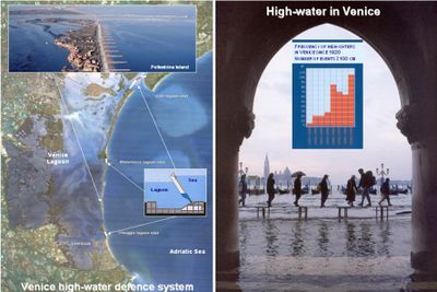
| + | [[Image:Ven.jpg|400px|thum|left|Satellite view of Venice lagoon and high water in St. Mark’ square (at the left hand-side)]] | ||
Various actions undertaken to enhance the industrial development of the city, together with natural | Various actions undertaken to enhance the industrial development of the city, together with natural | ||
phenomena, sea level rise and subsidence have led to a pronounced process of sinking of the city, about 23 | phenomena, sea level rise and subsidence have led to a pronounced process of sinking of the city, about 23 | ||
Revision as of 14:32, 10 March 2010
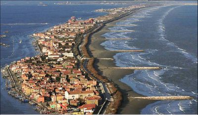
The Po River delta (and the adjoining coast), which developed out of the Adriatic Sea, is surrounded by the Venice lagoon in the North and the sandy coastal zone of the Romagna (Ravenna) with the Po plain to the rear, at the South up to the promontory of Gabicce, where the Apennines Mountains meet the Adriatic Sea. It covers an area of 73’000 hectares, of which 60’000 is reclaimed land and the remainder is brackish lagoons, with dams or open foreshores and emerging sandy banks. The port of Ravenna is one of the main ports in Italy. Its location in the Adriatic Sea makes it perfect for trade with the East, Mediterranean countries and the Far East. The port's history dates back to the Roman Emperor Augustus, who, at one time, stationed one of his imperial fleets in the port. Now the port is a perfect gateway for tourists travelling to the coast of Croatia. The ferry passenger terminal at Ravenna port is well-equipped and capable of holding up to 2’000 people, being on average 8000 the ships per year that pass through the harbour. Venice Lagoon (Fig. 9) has a surface area of about 550 km². It is not only the largest lagoon, but has the widest tidal range of the Mediterranean Sea. Three inlets, Lido, Malamocco, and Chioggia, connect it to the Northern Adriatic Sea. The lagoon can be split into four first-rank basins, named Chioggia, Malamocco, Lido, Treporti, with surface areas of about 130, 170, 100, 150 km2 respectively. The Venice Lagoon System has a variety of habitats, including dunes, tidal channels, bare mudflats, seagrass beds, and salt marshes. It is a Ramsar site and has important ecological functions like all others wetlands. During the winter season, more than 100.000 migrating waterfowl rest in the lagoon area, seven species live here all year round. Two main cities, Venezia and Chioggia, and a number of towns and villages with a total population of 400,000 are located around the lagoon and on some islands. About 20 million tourists visit the historical city of Venice each year while the resident population is only 60,000. Venice has one of the most important ports in Italy. 30 million tonnes of goods are shipped per year and the number of cruise ship passengers is 1 million. Venice also has the third busiest Italian airport and Italy’s petrochemical and chemical industry (Marghera) has its roots here.
Various actions undertaken to enhance the industrial development of the city, together with natural phenomena, sea level rise and subsidence have led to a pronounced process of sinking of the city, about 23 cm in the last century, and an increased frequency of high tides. After a 30 year long debate, the political decision has finally been taken to built a mobile barrier system between the lagoon and the sea. The system includes mobile flood barriers at the lagoon inlets in order to isolate the lagoon from the sea in the case of high tides and raised lagoon banks and pavements in areas that lie lowest.

