Difference between revisions of "Slapton barrier beach case study, UK"
Dronkers J (talk | contribs) |
|||
| (22 intermediate revisions by 6 users not shown) | |||
| Line 1: | Line 1: | ||
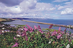
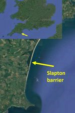
| − | Slapton | + | This is a short article drawing attention to a recent UK study concerning the prediction of morpological change at a major barrier beach system at Slapton, Devon, England. The study, commissioned by the Slapton Line Partnership (http://www.slaptonlinepartnership.co.uk/) was undertaken by the Coastal Engineering Research Group at the University of Plymouth, UK, in collaboration with consultants, Scott Wilson. |
| − | + | ||
| − | + | {| border="0" | |
| − | + | |- | |
| − | + | | valign="top"| | |
| − | + | [[File:Slapton1.jpg|thumb|left|500px|View Slapton barrier]] | |
| − | + | | valign="top"| | |
| − | Details | + | [[File:Slapton.jpg|thumb|left|150px| Location Slapton barrier]] |
| − | Slapton Sands is recognised for its nature conservation and landscape importance. The shingle ridge and Slapton Ley is designated as a Site of Special Scientific Interest (SSSI), as a National Nature Reserve (NNR) and as a Geological Conservation Review site. During a series of storms in the winter of 2000/01, significant damage occurred to the barrier beach at Slapton, where a 250 m section of the road was severely damaged. | + | |} |
| + | <br style="clear:both;"/> | ||
| + | |||
| + | =='''Project Details'''== | ||
| + | |||
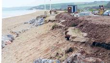
| + | Slapton Sands is recognised for its nature conservation and landscape importance. The shingle ridge and Slapton Ley is designated as a Site of Special Scientific Interest (SSSI), as a National Nature Reserve (NNR) and as a Geological Conservation Review site. During a series of storms in the winter of 2000/01, significant damage occurred to the barrier beach at Slapton, where a 250 m section of the road was severely damaged. | ||
| + | |||
| + | [[Image:Slapton3.JPG]] | ||
The study involved analysis of coastal processes on both geomorphological and contemporary timescales, numerical modelling of wave transformations and shoreline evolution, breach modelling and cross-shore profile modelling. It was found that the key beach processes affecting Slapton Sands are: short term storm impacts, | The study involved analysis of coastal processes on both geomorphological and contemporary timescales, numerical modelling of wave transformations and shoreline evolution, breach modelling and cross-shore profile modelling. It was found that the key beach processes affecting Slapton Sands are: short term storm impacts, | ||
| Line 15: | Line 22: | ||
The risk of a breach of the shingle bank will remain low over the next 30 to 50 years. Future sea-level rise and increased storminess will increase the rate of erosion and the risk of a major recession event. With no intervention measures, it is anticipated that the barrier beach will eventually be breached forming tidal inlets. | The risk of a breach of the shingle bank will remain low over the next 30 to 50 years. Future sea-level rise and increased storminess will increase the rate of erosion and the risk of a major recession event. With no intervention measures, it is anticipated that the barrier beach will eventually be breached forming tidal inlets. | ||
| + | |||
| + | =='''Further details of the study may be found in:'''== | ||
| + | |||
| + | Chadwick, A. J., Karunarathna, H., Gehrels, R., Massey, A. C., O’Brien, D. and Dales, D.(2005). A New Analysis of the Slapton Barrier Beach System. Maritime Engineering 158, 4, 147-161 [https://www.researchgate.net/publication/236783947_A_new_analysis_of_the_Slapton_Barrier_Beach_System_UK] | ||
| + | |||
| + | |||
| + | |||
| + | {{author | ||
| + | |AuthorID=11189 | ||
| + | |AuthorFullName= Prof. Chadwick, Andrew John | ||
| + | |AuthorName=Andrew chadwick }} | ||
| + | |||
| + | [[Category:Coastal protection]] | ||
| + | [[Category:Practice, projects and case studies in coastal management]] | ||
Latest revision as of 11:52, 6 July 2020
This is a short article drawing attention to a recent UK study concerning the prediction of morpological change at a major barrier beach system at Slapton, Devon, England. The study, commissioned by the Slapton Line Partnership (http://www.slaptonlinepartnership.co.uk/) was undertaken by the Coastal Engineering Research Group at the University of Plymouth, UK, in collaboration with consultants, Scott Wilson.
Project Details
Slapton Sands is recognised for its nature conservation and landscape importance. The shingle ridge and Slapton Ley is designated as a Site of Special Scientific Interest (SSSI), as a National Nature Reserve (NNR) and as a Geological Conservation Review site. During a series of storms in the winter of 2000/01, significant damage occurred to the barrier beach at Slapton, where a 250 m section of the road was severely damaged.
The study involved analysis of coastal processes on both geomorphological and contemporary timescales, numerical modelling of wave transformations and shoreline evolution, breach modelling and cross-shore profile modelling. It was found that the key beach processes affecting Slapton Sands are: short term storm impacts, medium term longshore transport gradients; long term sea-level rise causing rollback of the barrier beach.
The overall assessment of the January 2001 event is that it was caused by a combination of beach line recession due to differential longshore transport rates in the preceding autumn and the occurrence of a 1 in 25 year storm event lasting four days, which further cut back the profile, with the beach crest reaching road level.
The risk of a breach of the shingle bank will remain low over the next 30 to 50 years. Future sea-level rise and increased storminess will increase the rate of erosion and the risk of a major recession event. With no intervention measures, it is anticipated that the barrier beach will eventually be breached forming tidal inlets.
Further details of the study may be found in:
Chadwick, A. J., Karunarathna, H., Gehrels, R., Massey, A. C., O’Brien, D. and Dales, D.(2005). A New Analysis of the Slapton Barrier Beach System. Maritime Engineering 158, 4, 147-161 [1]
Please note that others may also have edited the contents of this article.
|


