Difference between revisions of "Auderville"
| (6 intermediate revisions by the same user not shown) | |||
| Line 5: | Line 5: | ||
:'''County''': Basse-Normandie | :'''County''': Basse-Normandie | ||
| − | Auderville is | + | Auderville is a town on the Cap de la Hague. Very touristy, Auderville is known for the port of Goury which houses the lifeboat station and lifeboat Mona Rigolet that comes out in all weather conditions, and the lighthouse of la Hague that stands on the rock "Gros du Raz" 800 m from the coast. It marks out the Raz Blanchard current and the passage between the Cap de la Hague and Alderney. A canon pointed towards the south once allowed the semaphore to alert the crew of the lifeboat.<ref>http://fr.wikipedia.org/wiki/Auderville</ref> |
| − | [[File:Auderville.JPG|frameless|500px|center]] | + | [[File:Auderville.JPG|frameless|500px|center|link=]] |
| − | :::::::::'''Picture''': Lighthouse of La Hague (Auderville)( | + | :::::::::'''Picture''': Lighthouse of La Hague (Auderville). (Author: Roelofs, 2010) |
{{Gifs -- Harbor template | {{Gifs -- Harbor template | ||
| Line 14: | Line 14: | ||
|vessel2=0 | |vessel2=0 | ||
|vessel3=0 | |vessel3=0 | ||
| − | |vesseltotal=2< | + | |vesseltotal=2 |
| − | + | |refvesseltotal=<ref>Data from 2011. Source: [http://sih.ifremer.fr/Publications/Syntheses/Synthese-par-quartier-region-et-facade/Mer-du-Nord-Manche-Atlantique/2011 Ifremer]</ref> | |
|locfisherorg=CRPMEM de Haute Normandie, 26, Quai Galliéni 76200 DIEPPE | |locfisherorg=CRPMEM de Haute Normandie, 26, Quai Galliéni 76200 DIEPPE | ||
CRPMEM du Nord/Pas de Calais/Picardie, 12, rue Solférino 62200 BOULOGNE-SUR-MER | CRPMEM du Nord/Pas de Calais/Picardie, 12, rue Solférino 62200 BOULOGNE-SUR-MER | ||
| − | |||
| − | |||
}} | }} | ||
'''Vessel type 1= Coastal fishing vessels:''' Vessels which spend more than 75% of their time in the 12 nm zone. <br/> | '''Vessel type 1= Coastal fishing vessels:''' Vessels which spend more than 75% of their time in the 12 nm zone. <br/> | ||
'''Vessel type 2= Coastal/high sea vessels:''' Fishing vessels that fish 25% -75% of their time in the 12 nm zone.<br/> | '''Vessel type 2= Coastal/high sea vessels:''' Fishing vessels that fish 25% -75% of their time in the 12 nm zone.<br/> | ||
| − | '''Vessel type 3= High sea vessels:''' vessels that fish more than 75% of their time outside the coastal zone. These vessels fish offshore the French coast but are in some cases active in the coastal zone of other countries.< | + | '''Vessel type 3= High sea vessels:''' vessels that fish more than 75% of their time outside the coastal zone. These vessels fish offshore the French coast but are in some cases active in the coastal zone of other countries.<ref>Leblond, E., Daures, F., Leonardi, S., Merrien, C., Demaneche, S., Le Blond, S., Berthou, P.L., Pitel-Roudau, M., Macher, C., Lespagnol, P., Le Grand, C., Le Blond, S. (2013). Synthèse des flottilles de pêche 2011, flotte de Mer du Nord - Manche – Atlantique, flotte de Méditerranée dans le cadre Réalisation du projet "Système d'Informations Halieutiques" de l'Ifremer. Edition [http://www.ifremer.fr/sih-resource-public/Publications/Syntheses/Synthese_flottilles_de_peche/2011/COMP_SYNTHESE_FLOTTILLE_2011.pdf IFREMER] Brest. p.289.</ref> |
===<span style="color:#3a75c4; Font-size: 130%">'''<small>References</small>'''</span>=== | ===<span style="color:#3a75c4; Font-size: 130%">'''<small>References</small>'''</span>=== | ||
| − | + | <references/> | |
| − | + | ||
| − | + | {{GIFS}} | |
| + | [[category: Background information]] | ||
| + | [[category: Ports France]] | ||
Latest revision as of 12:03, 19 November 2014
Auderville
- Administrative Port: Manche
- County: Basse-Normandie
Auderville is a town on the Cap de la Hague. Very touristy, Auderville is known for the port of Goury which houses the lifeboat station and lifeboat Mona Rigolet that comes out in all weather conditions, and the lighthouse of la Hague that stands on the rock "Gros du Raz" 800 m from the coast. It marks out the Raz Blanchard current and the passage between the Cap de la Hague and Alderney. A canon pointed towards the south once allowed the semaphore to alert the crew of the lifeboat.[1]
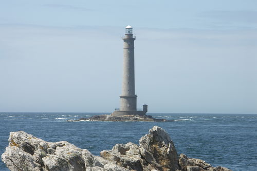
- Picture: Lighthouse of La Hague (Auderville). (Author: Roelofs, 2010)
| Background information | |||
|---|---|---|---|
| Fishing Fleet | Vessel type 1 | 2 | |
| Fishing Fleet | Vessel type 2 | 0 | |
| Fishing Fleet | Vessel type 3 | 0 | |
| Fishing Fleet | Vessels total | 2 [2] | |
| Landings | Total Landings (tonnes) | Demersal (tonnes) | |
| Landings | Total Landings (tonnes) | Pelagic (tonnes) | |
| Landings | Total Landings (tonnes) | Shellfish (tonnes) | |
| Landings | Total Landings (tonnes) | Main species (tonnes) | |
| Landings | Total Landings (tonnes) | All species (tonnes) | |
| Landings | Values | Demersal | |
| Landings | Values | Pelagic | |
| Landings | Values | Shellfish | |
| Landings | Values | All species | |
| Landings | Number of fishermen | Number of fishermen (Regular) | |
| Landings | Number of fishermen | Number of fishermen (Part-time) | |
| Landings | Number of fishermen | Number of fishermen Total | |
| Landings | Major fish species | ||
| Landings | Landing points | ||
| Landings | Location of auctions | ||
| Governance and organisation | Governance | ||
| Governance and organisation | FLAG | ||
| Governance and organisation | Location of fishermen's organisations | CRPMEM de Haute Normandie, 26, Quai Galliéni 76200 DIEPPE
CRPMEM du Nord/Pas de Calais/Picardie, 12, rue Solférino 62200 BOULOGNE-SUR-MER | |
| Branding | Brand labels | ||
| Fish as food | Fish selling | ||
| Fish as food | Fish processing | ||
| Fish as food | Restaurants/hotels | ||
| Tourism & Education | Tourism & Fishing | ||
| Tourism & Education | Festivals | ||
| Tourism & Education | Fishing museums | ||
| Tourism & Education | Aquariums | ||
| Tourism & Education | Monuments | ||
| Tourism&Education | Fishing training School | ||
Vessel type 1= Coastal fishing vessels: Vessels which spend more than 75% of their time in the 12 nm zone.
Vessel type 2= Coastal/high sea vessels: Fishing vessels that fish 25% -75% of their time in the 12 nm zone.
Vessel type 3= High sea vessels: vessels that fish more than 75% of their time outside the coastal zone. These vessels fish offshore the French coast but are in some cases active in the coastal zone of other countries.[3]
References
- ↑ http://fr.wikipedia.org/wiki/Auderville
- ↑ Data from 2011. Source: Ifremer
- ↑ Leblond, E., Daures, F., Leonardi, S., Merrien, C., Demaneche, S., Le Blond, S., Berthou, P.L., Pitel-Roudau, M., Macher, C., Lespagnol, P., Le Grand, C., Le Blond, S. (2013). Synthèse des flottilles de pêche 2011, flotte de Mer du Nord - Manche – Atlantique, flotte de Méditerranée dans le cadre Réalisation du projet "Système d'Informations Halieutiques" de l'Ifremer. Edition IFREMER Brest. p.289.