Difference between revisions of "Case study Barfleur"
(→The mussel fishery of eastern Cotentin (Lower Normandy, France)) |
|||
| Line 3: | Line 3: | ||
=== 1. Presentation and history === | === 1. Presentation and history === | ||
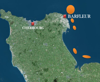
| + | The [http://wwz.ifremer.fr/lern/Aide-a-la-decision/DILEMES wild mussel from eastern Cotentin], Mytilus edulis, is fished using dredges since 1962, although some deposits that are accessible on foot at low tide have been exploited by the local population for a long time. There are five main deposits exploited at sea, all between 5 and 50 meters depth<ref>IFREMER, 2004. La moule. 5 p. [Online]. envlit.ifremer.fr/content/download/34084/281640/version/.../moule.pdf. Visited on 21 November 2013.</ref>: four of them are in the department of [https://www.google.fr/maps/place/Manche/@49.0917794,-1.344906,9z/data=!3m1!4b1!4m2!3m1!1s0x480b8bb8055935f7:0x30c14484fb528a0 Manche], offshore of Barfleur, Moulard, Réville and Ravenoville and one is offshore of Grandcamp in the Calvados (Figure 1). In terms of area, the [https://www.google.fr/maps/place/Barfleur/@49.6688145,-1.2652065,16z/data=!3m1!4b1!4m2!3m1!1s0x480b67ec00ac1043:0x40c14484fb98420 Barfleur] deposit, which is the most northern, is by far the most important French fishing deposit of wild mussels, with over 2 000 ha<ref>COCHARD M-L et MORIN J., 2013. Les gisements mouliers de l’Est Cotentin. Compte-rendu de la prospection 2013, Ifremer, July 2013, 27 p.</ref>. | ||
| − | [[Image:Fig Barfleur.png| | + | [[Image:Fig Barfleur.png|400px]] [[Image:Fig 2 barfleur.png|318px]] |
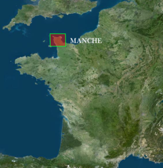
| − | :: | + | ::'''Figure 1: Distribution of the five natural mussel (Mytilus edulis) deposits of eastern Cotentin (Cochard et al., 2013)''' |
| − | < | + | Fishing takes place on deposits that all display significant interannual variability in terms of biomass. Indeed, between 1980 and 2010, the annual biomass indices, all deposits combined, are comprised between 1 000 and 20 000 tonnes (Personal communication from the CRPMEM BN, 2014). Therefore, a scientific monitoring, carried out by Ifremer, was set up to better understand the stock and adjust fishing effort to the available resource. Its exploitation is seasonal; fishing is generally only open between June and November, depending on the abundance and size of mussels on each deposit. The seasonality of fishing implies that all vessels practice at least one other fishing trade; for most, that is dredging for Great Atlantic scallops and/or trawling<ref>MONTFORT M-C. et TESSERON R., 2006. Moules de l’Est Cotentin, Commercialisation. Regional Committee for Maritime Fisheries and Marine Fish Farms of Lower Normandy. 74 p.</ref>. |
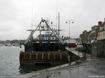
| − | + | Fishing concerns 64 vessels for the 2013 season and depending on the year, between 100 and 250 sailors exploit this product. For the 2013 fishing season, approximately 6 000 tonnes of mussels were landed. The two main landing ports for commercially harvested mussels are [https://www.google.fr/maps/place/Saint-Vaast-la-Hougue/@49.5940475,-1.2653239,13z/data=!3m1!4b1!4m2!3m1!1s0x480b65d1ace18985:0xcd171c92aa5281b9 Saint-Vaast la Hougue] and [https://www.google.fr/maps/place/Barfleur/@49.6688145,-1.2652065,16z/data=!3m1!4b1!4m2!3m1!1s0x480b67ec00ac1043:0x40c14484fb98420 Barfleur] (Figure 2). | |
| − | |||
| − | + | [[Image:Fig 3 barfl.jpg|center|400px]] | |
| − | + | ::::::::::::::::::::::'''Figure 2: Port of Barfleur''' | |
| − | + | ||
| − | + | ||
| − | + | ||
| − | + | <references/> | |
| − | |||
| − | |||
| − | |||
| − | |||
| − | |||
| − | |||
| − | |||
{{GIFS}} | {{GIFS}} | ||
Revision as of 10:50, 2 July 2014
The mussel fishery of eastern Cotentin (Lower Normandy, France)
1. Presentation and history
The wild mussel from eastern Cotentin, Mytilus edulis, is fished using dredges since 1962, although some deposits that are accessible on foot at low tide have been exploited by the local population for a long time. There are five main deposits exploited at sea, all between 5 and 50 meters depth[1]: four of them are in the department of Manche, offshore of Barfleur, Moulard, Réville and Ravenoville and one is offshore of Grandcamp in the Calvados (Figure 1). In terms of area, the Barfleur deposit, which is the most northern, is by far the most important French fishing deposit of wild mussels, with over 2 000 ha[2].
- Figure 1: Distribution of the five natural mussel (Mytilus edulis) deposits of eastern Cotentin (Cochard et al., 2013)
Fishing takes place on deposits that all display significant interannual variability in terms of biomass. Indeed, between 1980 and 2010, the annual biomass indices, all deposits combined, are comprised between 1 000 and 20 000 tonnes (Personal communication from the CRPMEM BN, 2014). Therefore, a scientific monitoring, carried out by Ifremer, was set up to better understand the stock and adjust fishing effort to the available resource. Its exploitation is seasonal; fishing is generally only open between June and November, depending on the abundance and size of mussels on each deposit. The seasonality of fishing implies that all vessels practice at least one other fishing trade; for most, that is dredging for Great Atlantic scallops and/or trawling[3]. Fishing concerns 64 vessels for the 2013 season and depending on the year, between 100 and 250 sailors exploit this product. For the 2013 fishing season, approximately 6 000 tonnes of mussels were landed. The two main landing ports for commercially harvested mussels are Saint-Vaast la Hougue and Barfleur (Figure 2).
- Figure 2: Port of Barfleur
- ↑ IFREMER, 2004. La moule. 5 p. [Online]. envlit.ifremer.fr/content/download/34084/281640/version/.../moule.pdf. Visited on 21 November 2013.
- ↑ COCHARD M-L et MORIN J., 2013. Les gisements mouliers de l’Est Cotentin. Compte-rendu de la prospection 2013, Ifremer, July 2013, 27 p.
- ↑ MONTFORT M-C. et TESSERON R., 2006. Moules de l’Est Cotentin, Commercialisation. Regional Committee for Maritime Fisheries and Marine Fish Farms of Lower Normandy. 74 p.


