File list
This special page shows all uploaded files.
| Date | Name | Thumbnail | Size | User | Description | Versions |
|---|---|---|---|---|---|---|
| 11:54, 5 April 2020 | PhysicalBarrier.jpg (file) |  |
399 KB | Dronkers J | Physical subsurface barrier at the seaward entrance of an aquifer. | 2 |
| 11:53, 5 April 2020 | HydraulicAbstractionBarrier.jpg (file) |  |
491 KB | Dronkers J | Hydraulic abstraction barrier at the seaward entrance of an aquifer. | 1 |
| 11:51, 5 April 2020 | HydraulicInjectionBarrier.jpg (file) |  |
497 KB | Dronkers J | Hydraulic injection barrier at the seaward entrance of an aquifer. | 1 |
| 11:49, 5 April 2020 | Freshkeeper.jpg (file) |  |
296 KB | Dronkers J | Principle of the freshkeeper system: removal of brackish groundwater to a lower aquifer to make room for storage of fresh water. | 1 |
| 11:48, 5 April 2020 | Freshmaker.jpg (file) |  |
580 KB | Dronkers J | Principle of the freshmaker system: withdrawal of brackish groundwater to make room for a thick fresh water lens. | 1 |
| 11:47, 5 April 2020 | TemporaryStorage.jpg (file) |  |
578 KB | Dronkers J | Temporary storage of rainwater. | 1 |
| 11:46, 5 April 2020 | DuneInfiltration.jpg (file) |  |
284 KB | Dronkers J | Large fresh water reservoir created by dune infiltration. | 2 |
| 11:43, 5 April 2020 | SkimmingWell.jpg (file) |  |
561 KB | Dronkers J | Horizontal skimming well. The upconing effect is limited by spreading the extraction is spread over a broad zone. | 1 |
| 11:38, 5 April 2020 | PolderDrainage.jpg (file) |  |
584 KB | Dronkers J | Drainage of a polder causing upconing of brackish water into the ditches. | 1 |
| 11:37, 5 April 2020 | UpconingWell.jpg (file) |  |
339 KB | Dronkers J | Upconing brackish water under a pumping well. | 1 |
| 11:35, 5 April 2020 | MarineTransgression.jpg (file) | 546 KB | Dronkers J | Infiltration of marine flood water into the underground. | 1 | |
| 11:34, 5 April 2020 | GroundwaterExtractionTrends.jpg (file) |  |
48 KB | Dronkers J | Agricultural groundwater usage for selected countries in billion km3/year. Source: UN World Water Development Report, 2015 | 1 |
| 11:31, 5 April 2020 | AirborneTEM.jpg (file) |  |
45 KB | Dronkers J | SkyTEM team recording Time Domain Electromagnetic Data. Source: G. Oude Essink, https://publicwiki.deltares.nl/ | 1 |
| 10:24, 5 April 2020 | WorldWaterDistribution.png (file) |  |
92 KB | Dronkers J | World water distribution. Credit: pbslearningmedia. | 1 |
| 11:16, 4 April 2020 | SaltFreshBalance.jpg (file) |  |
32 KB | Dronkers J | A small level difference is sufficient to keep a large fresh water column in balance with a salt water column, because of the small relative density difference. | 1 |
| 21:54, 28 March 2020 | SubmergedBreakwater.jpg (file) |  |
172 KB | Dronkers J | Submerged breakwater (negative freeboard). The graph shows the range of values for the wave transmission coefficient obtained from experiments. | 1 |
| 16:26, 28 March 2020 | ReshapingBermBreakwater.jpg (file) |  |
125 KB | Dronkers J | Fully reshaping berm breakwater. | 1 |
| 17:40, 21 March 2020 | LiquefactionPrinciple.jpg (file) |  |
61 KB | Dronkers J | Principle of soil liquefaction. | 1 |
| 19:41, 19 March 2020 | FallingApron.jpg (file) |  |
158 KB | Dronkers J | Principle of the falling apron. | 1 |
| 19:41, 19 March 2020 | ConcreteArmorUnits.jpg (file) |  |
93 KB | Dronkers J | Examples of concrete armor units. | 1 |
| 19:40, 19 March 2020 | SlipFailure.jpg (file) |  |
131 KB | Dronkers J | Slip failure of the breakwater core. | 1 |
| 19:39, 19 March 2020 | SeabedLiquefaction.jpg (file) |  |
140 KB | Dronkers J | Collapse of the armor layer due to seabed liquefaction under the toe of the breakwater. | 1 |
| 19:38, 19 March 2020 | CrownElement.jpg (file) |  |
54 KB | Dronkers J | Breakwater with crown element. | 1 |
| 19:37, 19 March 2020 | RearSideFailure.jpg (file) |  |
134 KB | Dronkers J | Erosion of the rear side of the breakwater due to overtopping waves. | 1 |
| 19:36, 19 March 2020 | OffshoreBreakwaterShoreRevetment.jpg (file) |  |
135 KB | Dronkers J | Left panel: Offshore rubble-mound breakwater. Right panel: Rubble-mound revetment protecting the backshore. | 1 |
| 12:49, 29 February 2020 | Figure6 3 COLOR.png (file) |  |
493 KB | Dronkers J | Global map of the amplitude of quarterdiurnal tide M4. | 1 |
| 12:46, 29 February 2020 | Figure5 2 COLOR.png (file) |  |
491 KB | Dronkers J | Global map of the luni-solar declinational diurnal component K1. | 1 |
| 12:44, 29 February 2020 | Figure5 1 COLOR.png (file) |  |
608 KB | Dronkers J | Global map of the principal lunar semidiurnal component. | 1 |
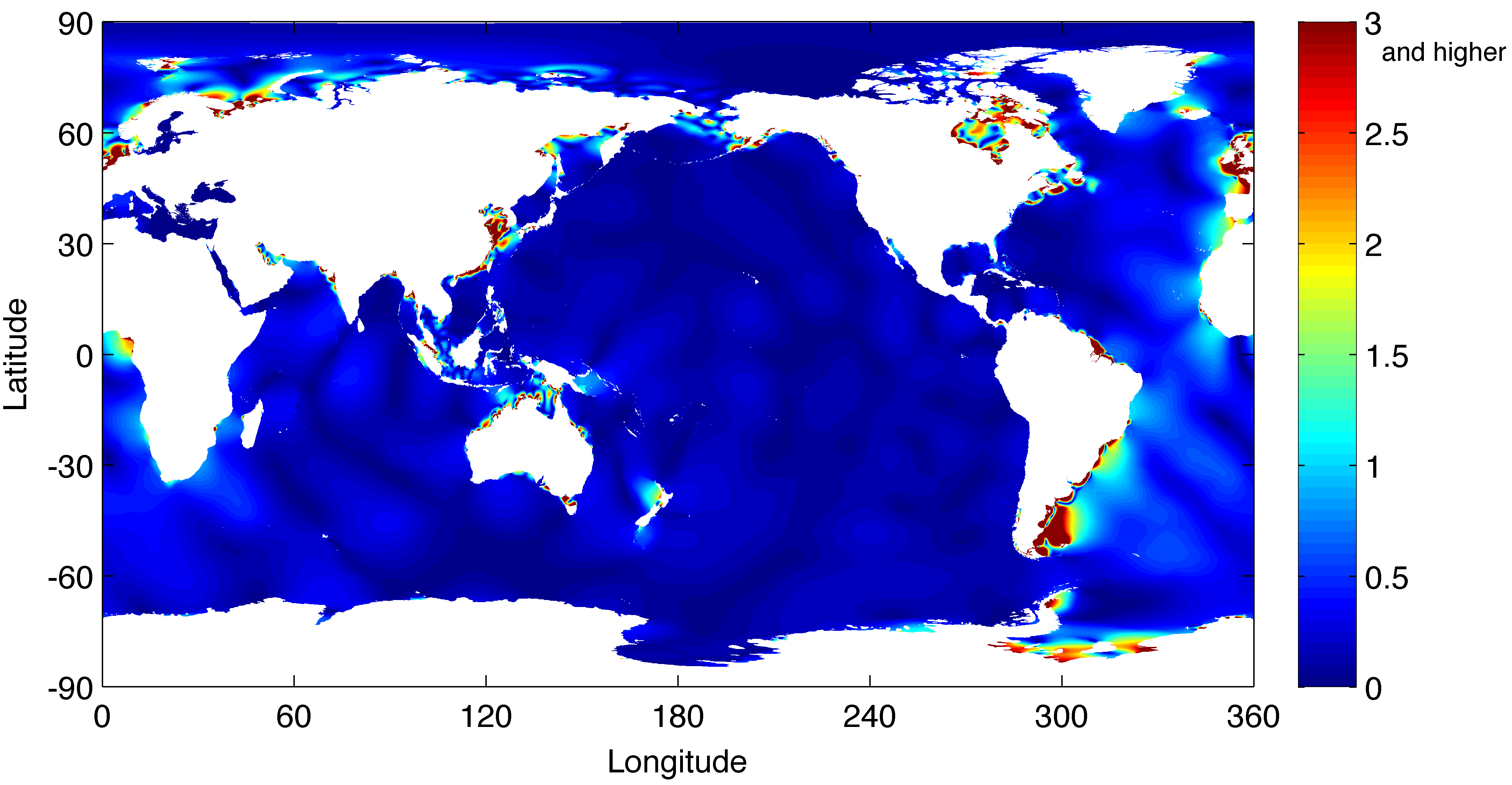
| 12:44, 29 February 2020 | Figure1 3 COLOR.png (file) |  |
93 KB | Dronkers J | Global distribution of the tidal range. | 1 |
| 12:43, 29 February 2020 | Figure1 2 COLOR.png (file) |  |
105 KB | Dronkers J | Global distribution of semidiurnal, diurnal and mixed tides. | 1 |
| 13:43, 22 February 2020 | DamBreakFlowDerivation.jpg (file) |  |
311 KB | Dronkers J | Derivation of the solution for frictionless dam break flow. | 1 |
| 13:40, 22 February 2020 | Dijkdoorbraak1953.jpg (file) |  |
314 KB | Dronkers J | Sea dikes protecting low-lying polders in the Netherlands were breached during the extreme storm surge of 31 January 1953. | 1 |
| 16:46, 21 February 2020 | AccraCloggedDrainageCanals.jpg (file) |  |
167 KB | Dronkers J | Clogged drainage canals in Accra (Ghana). Photo credit TU Delft. | 1 |
| 11:40, 19 February 2020 | FreshMakerSystem.jpg (file) |  |
55 KB | Dronkers J | Creation of a fresh water lens by fresh water infiltration after artificial lowering of the salt water interface. | 1 |
| 11:39, 19 February 2020 | PaleochannelInfiltration.jpg (file) |  |
43 KB | Dronkers J | Schematic representation of the underground fresh water reservoir created by fresh water infiltration in a sandy paleochannel deposit protruding above the mean land level. | 1 |
| 11:38, 19 February 2020 | HydraulicBarrier.jpg (file) |  |
103 KB | Dronkers J | Schematic representation of a hydraulic barrier at the seaward entrance of an aquifer. | 1 |
| 11:37, 19 February 2020 | SeepageMechanisms.jpg (file) |  |
183 KB | Dronkers J | Illustration of different seepage processes. | 1 |
| 11:36, 19 February 2020 | GroundwaterManagementAspects.jpg (file) |  |
173 KB | Dronkers J | Factors that influence the groundwater system. | 1 |
| 11:34, 19 February 2020 | SeepageUpconing.jpg (file) |  |
37 KB | Dronkers J | Salt water upconing under a seepage hotspot. | 1 |
| 11:34, 19 February 2020 | AbstractionUpconing.jpg (file) |  |
92 KB | Dronkers J | Salt water upconing under an abstraction well. | 1 |
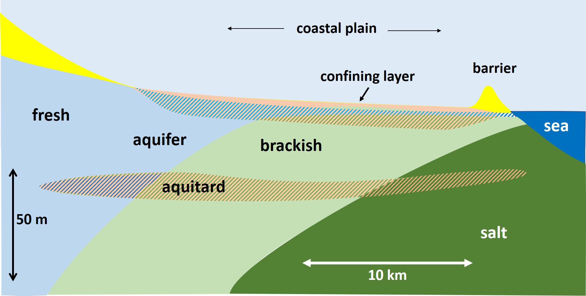
| 11:33, 19 February 2020 | SeawaterIntrusionScheme2.jpg (file) |  |
206 KB | Dronkers J | Schematic representation of seawater intrusion into a coastal aquifer with confining top layer. | 1 |
| 11:32, 19 February 2020 | SeawaterIntrusionScheme1.jpg (file) |  |
85 KB | Dronkers J | Schematic representation of seawater intrusion into a homogeneous coastal aquifer. | 1 |
| 22:53, 9 February 2020 | LoireOxygen.jpg (file) |  |
159 KB | Dronkers J | Dissolved oxygen concentration in the Loire estuary at Cordemais for the years 2007-2011. | 1 |
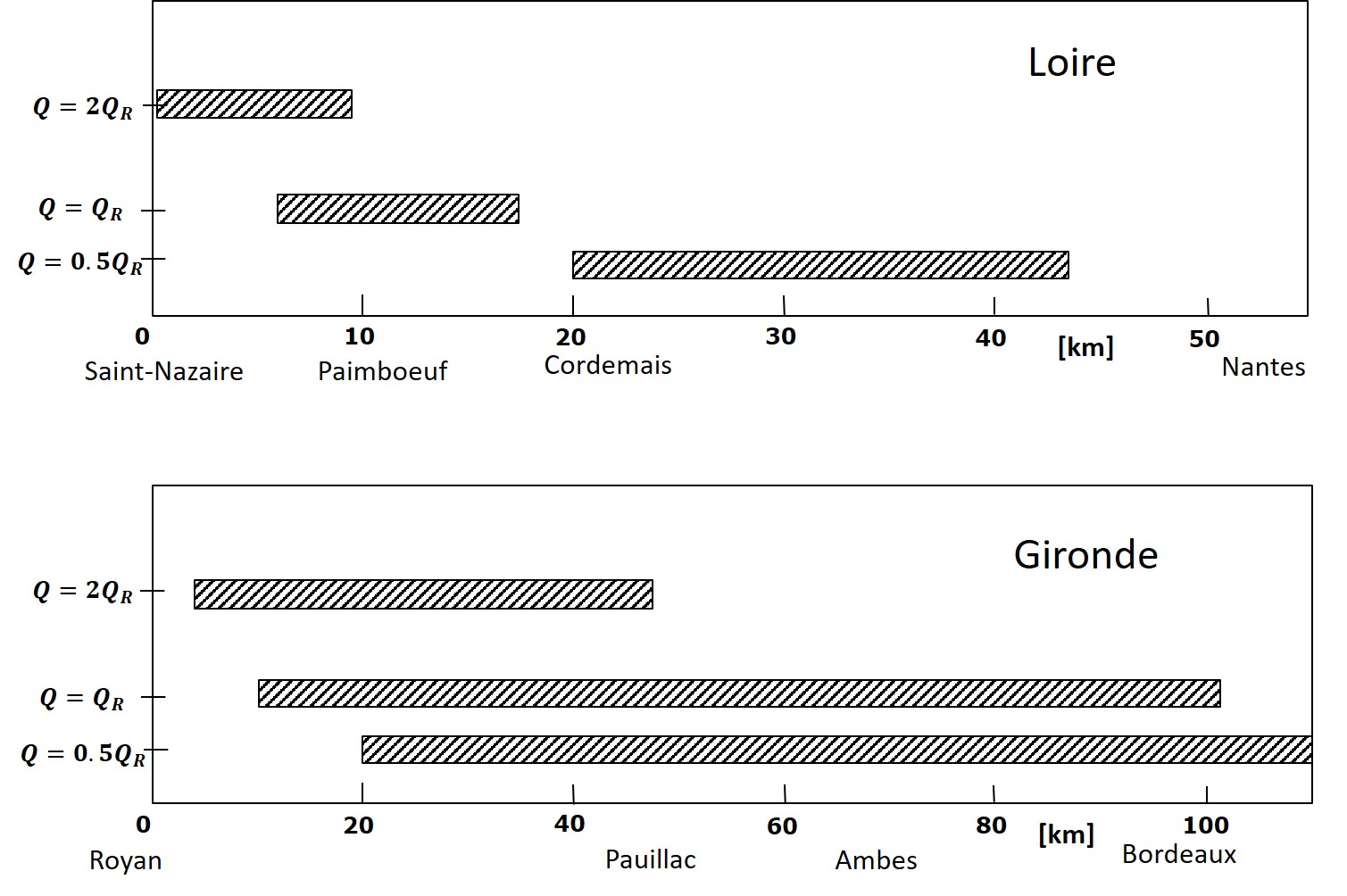
| 22:52, 9 February 2020 | DischargeLoireGirondeTurbidityMax.jpg (file) |  |
197 KB | Dronkers J | Position of the turbidity maximum in the Loire and Gironde estuaries for different fluvial discharges. | 1 |
| 22:52, 9 February 2020 | LandVanSaeftinghe.jpg (file) |  |
157 KB | Dronkers J | View of the Land van Saeftinghe. Photo credit Anita Eijlers | 1 |
| 22:50, 9 February 2020 | FluidMudLoireEstuary.jpg (file) |  |
233 KB | Dronkers J | Fluid mud in the Loire estuary during neap tide and low fluvial discharge. | 1 |
| 22:50, 9 February 2020 | TurbidityMaximumLoireEstuary.jpg (file) |  |
206 KB | Dronkers J | Turbidity maximum in the Loire estuary at low fluvial discharge. | 1 |
| 16:56, 5 February 2020 | WaterAssessmentAmsterdam.jpg (file) |  |
153 KB | Dronkers J | Assessment of policy objectives related to urban water management for the city of Amsterdam. | 1 |
| 16:34, 5 February 2020 | RoomForWaterCoastalCities.jpg (file) |  |
445 KB | Dronkers J | Examples of room for water in Dutch cities. | 1 |
| 16:31, 5 February 2020 | KatwijkCoastalProtection.jpg (file) |  |
24 KB | Dronkers J | The coastal village Katwijk (Netherlands) has been protected by an artificial dune built in front of the seashore boulevard with sand extracted far offshore. | 1 |