File list
This special page shows all uploaded files.
| Date | Name | Thumbnail | Size | User | Description | Versions |
|---|---|---|---|---|---|---|
| 15:57, 5 February 2019 | UKcoastalcells.jpg (file) |  |
98 KB | Dronkers J | Coastal sediment cells as defined for the coasts of England and Wales. | 1 |
| 12:29, 5 February 2019 | BoardwalkBarbados.jpg (file) |  |
433 KB | Dronkers J | View of the Boardwalk scheme in Barbados. | 1 |
| 12:28, 5 February 2019 | SMPscheme.jpg (file) |  |
211 KB | Dronkers J | Relationship between high level plans, strategies, schemes and other planning initiatives (Environmental Agency 2010) | 1 |
| 12:17, 10 December 2018 | NAO NCAR 2018.jpg (file) |  |
114 KB | Dronkers J | The winter (December through March) index of the NAO based <ref> [https://climatedataguide.ucar.edu/climate-data/hurrell-north-atlantic-oscillation-nao-index-station-based NCAR Boulder, US]</ref>. | 1 |
| 12:15, 10 December 2018 | NAO NOAA 2018.jpg (file) |  |
228 KB | Dronkers J | Interseasonal variation of the NAO index <ref>[http://www.cpc.ncep.noaa.gov/data/teledoc/nao.shtml NOAA]</ref>. | 1 |
| 15:05, 9 December 2018 | MangroveWorldMap.jpg (file) |  |
145 KB | Dronkers J | World distribution of mangroves | 1 |
| 21:49, 26 November 2018 | WesterscheldeSentinelMarch2016.jpg (file) |  |
474 KB | Dronkers J | Western Scheldt and Scheldt estuary, Netherlands, Belgium (Sentinel image). | 1 |
| 21:48, 26 November 2018 | ZambeziSentinelJan2017.jpg (file) |  |
277 KB | Dronkers J | Zambezi River Delta on the Indian Ocean, Mozambique (Sentinel image). | 1 |
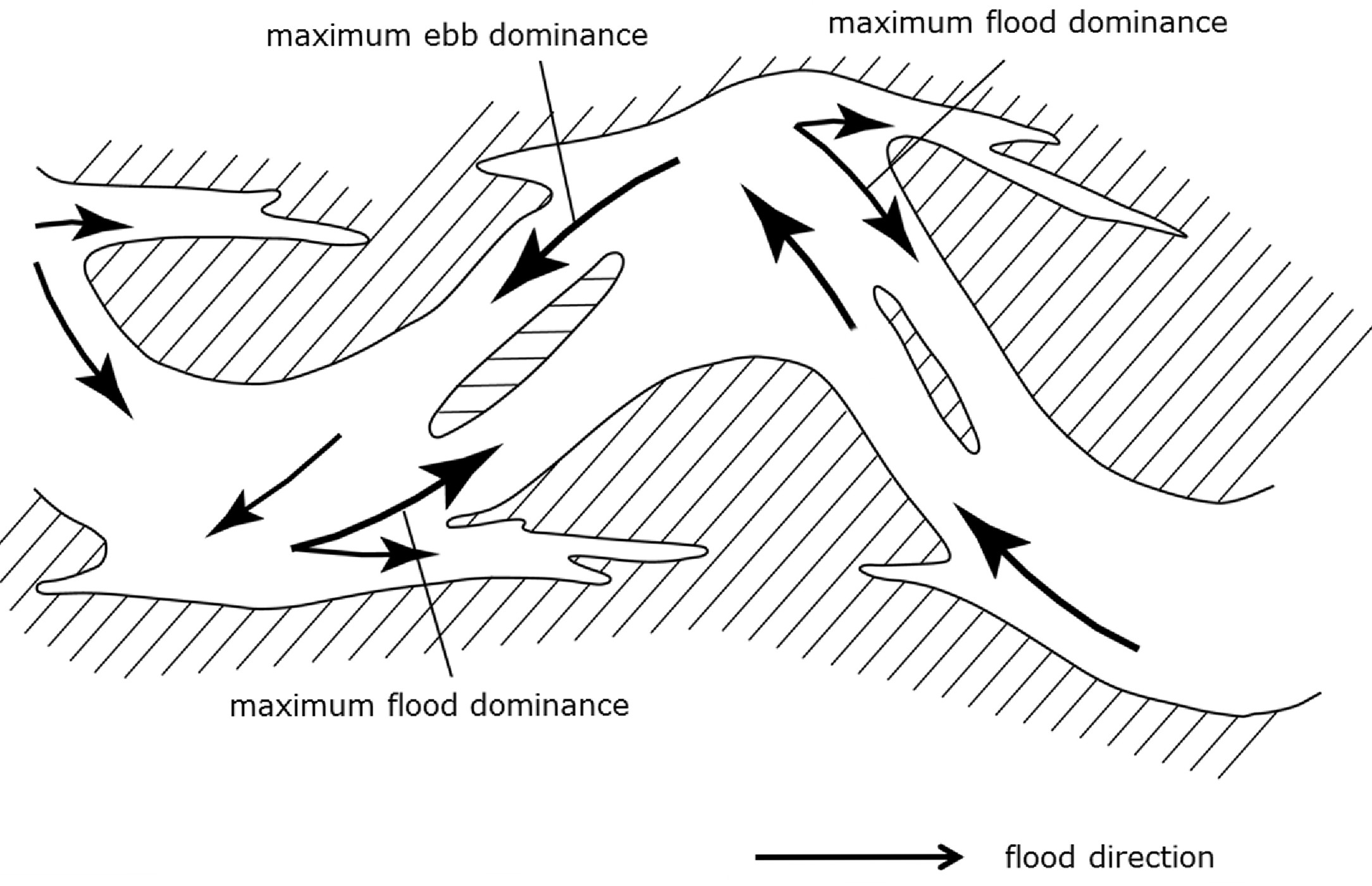
| 13:13, 26 November 2018 | EbbFloodMeander.jpg (file) |  |
312 KB | Dronkers J | Schematic picture of flood and ebb dominant flow channels in a meandering channel system. | 1 |
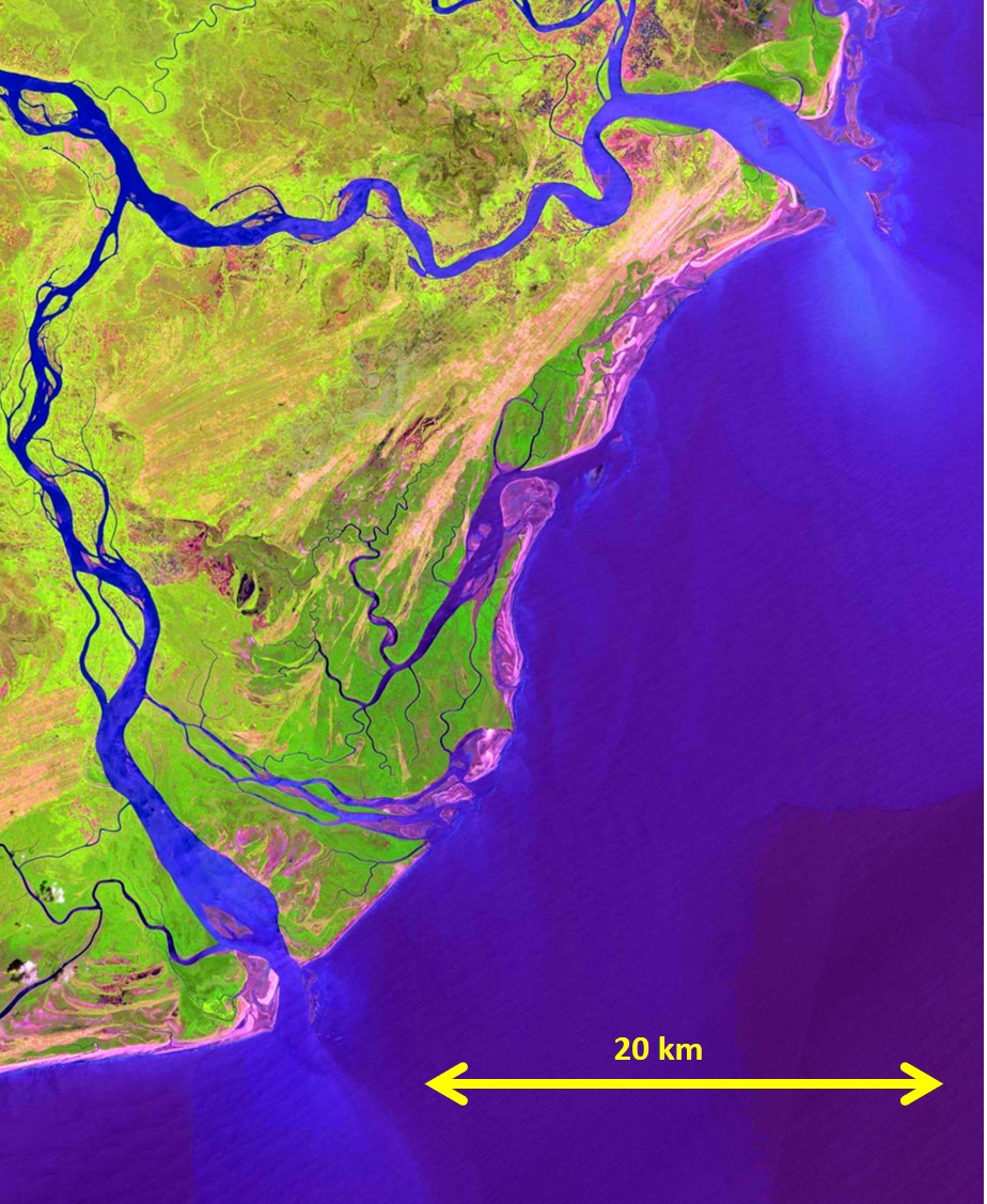
| 21:25, 25 November 2018 | HooghlySentinelJanuary2018.jpg (file) |  |
273 KB | Dronkers J | Hooghly estuary, Bay of Bengal, India (Sentinel image). | 1 |
| 20:44, 25 November 2018 | WillapaBaySentinelJuly2018.jpg (file) |  |
261 KB | Dronkers J | Willapa Bay on the US Pacific coast (Sentinel image). | 1 |
| 20:07, 25 November 2018 | CoronianLagoonSentinelSep2018.jpg (file) |  |
180 KB | Dronkers J | Curonian Lagoon, Baltic Sea coast(Sentinel image 10 September 2018) | 1 |
| 13:06, 18 November 2018 | GrainsizeBeachslope.jpg (file) |  |
120 KB | Dronkers J | Relation between fall velocity (sediment type) and beach slope as a function of the Dean parameter. | 1 |
| 00:00, 18 November 2018 | FallVelocityQuartz.jpg (file) |  |
53 KB | Dronkers J | Fall velocity of glass spheres of different sizes in still water. | 2 |
| 23:42, 17 November 2018 | EstuarineBedSedimentDistribution.jpg (file) |  |
383 KB | Dronkers J | Typical example of the spatial distribution of bed sediments in a coastal plain estuary, schematically represented. | 1 |
| 23:40, 17 November 2018 | SedimentMixtures.jpg (file) |  |
102 KB | Dronkers J | Classification of different types of graded sediment beds. | 1 |
| 23:39, 17 November 2018 | FlocRelativeFallVelocity.jpg (file) |  |
31 KB | Dronkers J | The ratio of floc fall velocity and fall velocity of the constituent particles. | 1 |
| 11:04, 14 November 2018 | ElementsLithosphere.jpg (file) |  |
34 KB | Dronkers J | Composition by weight of chemical elements in the lithosphere. | 1 |
| 11:03, 14 November 2018 | Worlderosion.jpg (file) |  |
543 KB | Dronkers J | Annual discharge of sediments from world's catchment basins. Redrawn after Milliman and Meade (1983). | 1 |
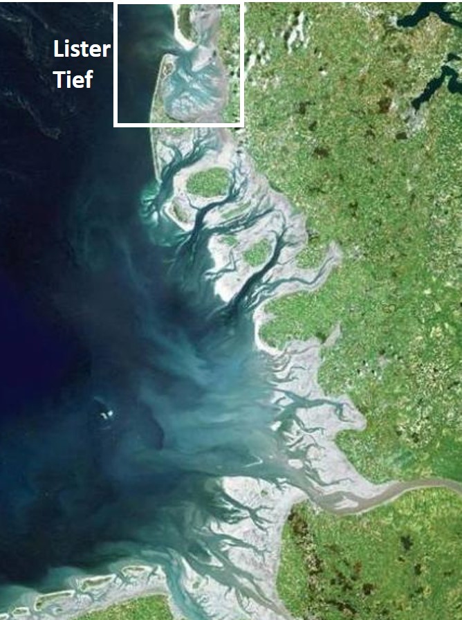
| 15:55, 10 November 2018 | ListerTief.jpg (file) |  |
141 KB | Dronkers J | Lister Tief in the German Wadden Sea. | 1 |
| 15:53, 1 October 2018 | 3.R WorldDeltas logaxis2-01.png (file) |  |
145 KB | JaapN | 1 | |
| 14:41, 29 September 2018 | TidalBorePetitcodiacRiver.jpg (file) |  |
521 KB | Dronkers J | Tidal bore in the Petitcodiac River (Bay of Fundy, Canada) | 1 |
| 13:32, 28 September 2018 | WorldmapM4.png (file) |  |
150 KB | Dronkers J | Coastal zones with important quarter-diurnal tide. | 1 |
| 15:54, 26 September 2018 | WorldDomM2.png (file) |  |
76 KB | Dronkers J | Coastal zones with dominant semi-diurnal tide. | 1 |
| 16:02, 25 September 2018 | DefinitionsCoastalTerms.jpg (file) |  |
150 KB | Dronkers J | Definition of coastal terms, adapted from Shore Protection Manual, 1984.<ref>Coastal engineering Research Center, Department of the Army, Waterways Experiment Station, 1984. "Shore protection manual".</ref> | 1 |
| 09:03, 21 September 2018 | BruunRule.jpg (file) |  |
199 KB | Dronkers J | Schematic representation of the shoreface shift in response to sea-level rise. The shaded eroded and deposited volumes are equal. | 1 |
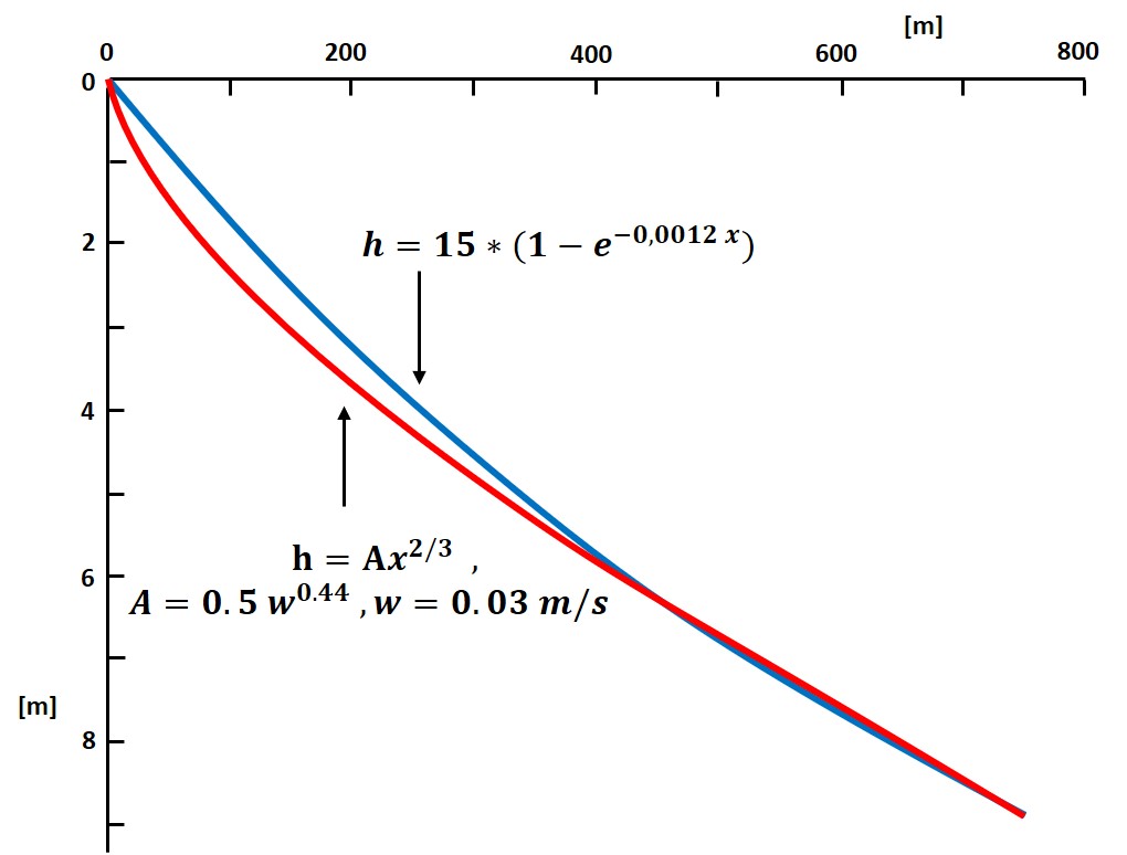
| 15:28, 18 September 2018 | DeanAndBodgeProfiles.jpg (file) |  |
62 KB | Dronkers J | The Bruun/Dean shoreface profile and the equivalent Bodge profile. | 1 |
| 12:55, 18 September 2018 | DutchCoastNorthHolland.jpg (file) |  |
1.02 MB | Dronkers J | The barred coast of North Holland, The Netherlands. https://beeldbank.rws.nl, Rijkswaterstaat / Rens Jacobs | 1 |
| 16:42, 14 September 2018 | SeaLevelRise IPCC AR5.jpg (file) |  |
87 KB | Dronkers J | Compilation of sea level data derived from observations up till 2010 and model projections up till 2100, relative to pre-industrial values. From IPCC 5th Assessment report Technical Summary WG1. | 1 |
| 14:15, 21 June 2018 | Benidorm EnriqueDomingo jpg.jpg (file) |  |
499 KB | Dronkers J | Tourist resort Benidorm on the Spanish Mediterranean coast. Photo credit Enrique Domingo [https://www.flickr.com/photos/edomingo/] | 1 |
| 14:14, 21 June 2018 | AmericanJackknifeClam jpmm.jpg (file) |  |
243 KB | Dronkers J | The American jackknife clam ''Ensis Directus'' has colonized the beaches of NW Europe. Photo credit jpmm, [https://www.flickr.com/photos/jpmm/] | 1 |
| 14:13, 21 June 2018 | LookingDownTheNileFromTheAswanDam JorgeLascar.jpg (file) |  |
196 KB | Dronkers J | Looking down the Nile from the Aswan Dam. Photo credit Jorge Lascar | 1 |
| 14:12, 21 June 2018 | DredgingMaasvlakte2.jpg (file) |  |
84 KB | Dronkers J | Dredging for the construction of Rotterdam port extension Maasvlakte 2. Photo credit Port of Rotterdam. | 1 |
| 14:11, 21 June 2018 | LeHavrePort2000.jpg (file) |  |
252 KB | Dronkers J | The port of Le Havre at the mouth of the Seine River is surrounded by a nature reserve zone. Photo credit Port of Le Havre. | 1 |
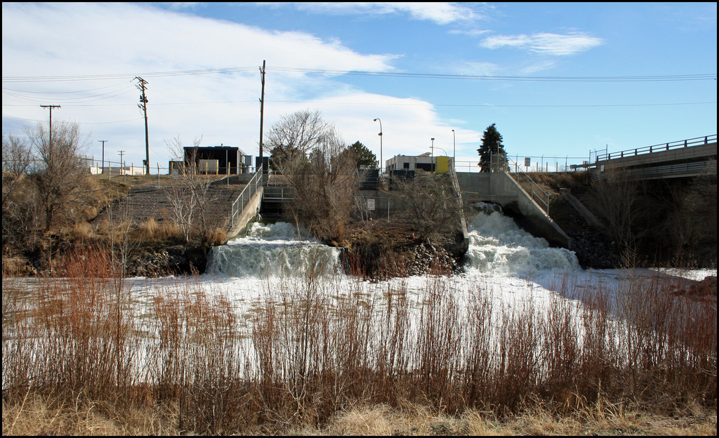
| 21:28, 10 June 2018 | SewageEffluentDenver.jpg (file) |  |
485 KB | Dronkers J | Sewage effluent Denver in Platte River. Photo credit Jeffrey Beall (2008) | 1 |
| 11:32, 8 June 2018 | CoastStormsWaves.jpg (file) |  |
129 KB | Dronkers J | Global distribution of storm and wave climate. Blue: Coasts subjected to storm waves. Red: Coasts subjected to tropical storms. Green: Coasts subjected to ocean swell waves. Adapted from Davies (1973) | 2 |
| 15:39, 7 June 2018 | FringingReefDevelopment.jpg (file) |  |
140 KB | Dronkers J | Typical evolution stages of a fringing reef. Adapted from Mergner and Schuhmacher (1974) | 1 |
| 19:43, 21 May 2018 | Groyne.jpg (file) |  |
230 KB | Dronkers J | Typical impact of a groyne on a littoral drift beach: accretion at the updrift side and erosion at the downdrift side. Photo credit: Dan Scutter. | 1 |
| 18:53, 21 May 2018 | SedimentRetentionRiverDams.jpg (file) |  |
224 KB | Dronkers J | Catchment basins with percentage of sediment discharge retained in artificial reservoirs, image from Vorosmarty et al (2003). | 1 |
| 11:59, 21 May 2018 | SeawallDowndriftErosionZanzibar.jpg (file) |  |
81 KB | Dronkers J | Beach erosion downdrift of a seawall at Zanzibar. | 1 |
| 11:59, 21 May 2018 | SeawallToe.jpg (file) |  |
657 KB | Dronkers J | Left: Low eroded beach at the Bardsea seawall, situated on the macrotidal Morecambe Bay (UK); Photo credit: Stephen Mackenzie. Right: Rock infill of a trench scoured at the toe of a seawall at Le Dicq (Island of Jersey): Photo credit: HR Wallingford. | 1 |
| 11:57, 21 May 2018 | NouakchottPorts.jpg (file) |  |
495 KB | Dronkers J | Left: The new seaport of Nouakchott (Mauritania) built in 1985 (image October 2017). Right: The (smaller) old port of Nouakchott, built in 1965, situated ten kilometers north of the new port (image April 2018). | 1 |
| 14:48, 28 April 2018 | RhineConcNitratePhosphate.jpg (file) |  |
41 KB | Dronkers J | Historic development of nitrate (a) and phosphate (b) concentrations in the Rhine. | 1 |
| 14:47, 28 April 2018 | Eutrophication Input Effect OSPAR2010.jpg (file) |  |
84 KB | Dronkers J | Sources of nutrient input to the marine environment and simplified schemes showing eutrophication effects arising from nutrient enrichment. OSPAR 2010. | 1 |
| 11:23, 27 April 2018 | DuneErosionEgmond.jpg (file) |  |
167 KB | Dronkers J | Dune scarp after collapse. | 1 |
| 11:21, 27 April 2018 | DuneScarpEgmond.jpg (file) |  |
308 KB | Dronkers J | Dune scarp at Egmond aan Zee after a storm surge. | 1 |
| 11:18, 27 April 2018 | DuneFailureMechanisms.jpg (file) |  |
72 KB | Dronkers J | Dune failure mechanisms. | 1 |
| 11:17, 27 April 2018 | BadhotelSchiermonnikoog 1924.jpg (file) |  |
19 KB | Dronkers J | Badhotel at Schiermonnikoog after the 1924 storm. | 1 |
| 22:13, 24 April 2018 | EgmondCoastalRetreat.jpg (file) |  |
88 KB | Dronkers J | Shoreline retreat Egmond aan Zee Dutch coast 17th-19th century. | 1 |
| 14:30, 24 April 2018 | ActiveCoastalZone.jpg (file) |  |
112 KB | Dronkers J | Schematic representation of the active coastal zone for a dune coast. | 1 |