Coastline
Definition of Coastline:
The coastline is a line that is considered the boundary between sea and land.
This is the common definition for Coastline, other definitions can be discussed in the article
|
The terms coastline and shoreline are often used indiscriminately as synonyms. However, it is generally preferable to define the shoreline as the physical transition between land and water and the coastline as a proxy of the shoreline position that designates the boundary between land and sea for use in shoreline management, see the article Shoreline.
Contents
Coastline definition
There is no unambiguous and generally adopted definition of the coastline. Each country has its own definition. Because of the highly dynamic nature of the shoreline, the chosen definition of the coastline has to be defined on appropriate space and time scales.
Criteria for defining a coastline include:
- providing a representative estimate of trends in coastal erosion or coastal accretion;
- the accuracy with which the location of the coastline can be determined;
- robustness (repeatability) of the corresponding measuring technique (e.g. not influenced by tide or wave run-up);
- the effort required to determine the coastline position;
- determining whether intervention is necessary if the coastline retreats (taking in account assets and interests at stake).
Several coastline choices are possible:
- A coastline based on fixed points (for example a cliff or seawall at the upper end of the beach). Disadvantage for sedimentary coasts: it does not provide insight into beach erosion or accretion.
- A coastline based on the instantaneous waterline. Disadvantage: the great variability, in particular the effect of tides.
- A coastline based on the average waterline at high tide or low tide. Satisfactory for rocky coasts, but disadvantage for sandy dune coasts: coastline variability is still considerable due to the influence of storms and the influence of seasonal variability in the wave climate.
- A coastline based on easily identifiable beach features, for example the dune foot, the most seaward vegetation line, the crest of the most landward beach berm. Advantages: beach erosion or accretion is reflected in retreat or advance of these coastal features, while the variability is much less than for the average LW or HW lines. Disadvantage: this coastline choice is sensitive to coastline retreat caused by occasional storms, which often has a temporary character and can be restored by natural processes when a calmer wave climate has established (see Dune erosion). Besides, the mentioned beach features are not present everywhere.
Shoreline detection techniques
An overview of shoreline detection technique is given in the article Shoreline.
Shoreline management based on structural erosion
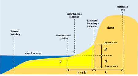
Shoreline management is primarily interested in long-term erosion trends, also called structural coastal erosion. Long-term erosion trends are the result of a structural deficit in the balance of sand input and sand output for a particular coastal section. To gain insight into this sand balance, it is necessary to monitor the sand volume of the active zone for sections along the entire coast. An example is the coastline definition used in the Netherlands, see Annex.
Annex: Coastline definition in the Netherlands

In the Netherlands, because large parts of the country are lying below mean sea level, the dune belt is of crucial importance to protect the hinterland against flooding. Structural beach erosion increases the vulnerability of the dune coast and is therefore systematically redressed along the entire coast by means of sand nourishments (see Beach nourishment and Shoreface nourishment). To determine where structural coastal erosion occurs, the coast has been divided into coastal sections of approximately 200m longitudinal length. A fictitious volume-based coastline has been defined for each section, which is related to the sand volume in this coastal section. Both the volume above the waterline and below the waterline are taken into account. The considered volume below the waterline is related to a water depth equal to the height of the dunefoot above the low waterline, see Fig. 1. This volume is determined annually through a coastal monitoring programme. Experience shows that trends in the variation of this fictitious coastline provide a reliable estimate of the structural erosion or accretion of the coast[1].
Related articles
- Shoreline
- Shoreline retreat and recovery
- Risk and coastal zone policy: example from the Netherlands
- Dune erosion
- Dealing with coastal erosion
- Integrated Coastal Zone Management (ICZM)
- Shoreline management
- Shoreface profile
- Active coastal zone
References
- ↑ RIKZ 1996. Coastline management, from coastal monitoring to sand nourishment. Ministry of Transport, Public Works and Water Management, Directorate-General for Public Works and Water Management, National Institute for Coastal and Marine Management/RIKZ
Please note that others may also have edited the contents of this article.
|